Yet my eyes are drawn towards the mountain in the east
It fascinates and captivates and gives my heart no peace
The mountain holds the sunrise in the prison of the night
Then bursting forth from rocky chains the valley floods with light
- Rush, The Fountain of Lamneth, 1975
All mountains are not created equal. For the peakbagger, every designated peak has the same numerical 'value'. For state high points, the flat featureless suburbs of Delaware counts just as much as the foreboding alpine tundra of New Hampshire. For Catskill high peaks, the wide easy switchbacks of Bearpen are just as important as the impenetrable bushwhack on Rocky. But in terms of climbing experience, in terms of quality, some mountains are more fun, more challenging, more rewarding. Some mountains are special.
Katahdin first caught my attention back in 2018, before I was seriously climbing, before I even knew what 'highpointing' was. The existence of such rugged terrain, without all the commercial development of Mount Washington, fascinated me. The dangerous scrambles of the Knife Edge, exposed glacial cirques, and extreme isolation made Maine's highest point a major goal - one that seemed unachievable at the time. The next few years of hiking would see Katahdin as a far-off goal.
More concretely, I had planned on hiking the impressive peak at the end of last summer, but the park regulations, reservations, and restrictions made it infeasible with my schedule, and I ended up bagging some other state high points in the mid-Atlantic region instead. This summer, I adopted a policy of "Katahdin by any means necessary", placing the mountain as my primary goal. I had a week off work at the end of June and managed to reserve my spot on my lunch break a few weeks before. Once the call was placed, it was settled: I was climbing the mountain.
ONE: ARRIVAL
"Good luck! Don't fall off the mountain and die!"
Katahdin is famous for two things: The sketchy and beautiful hike along the Knife Edge, and the frustrating difficulty of actually getting there. Maine's high point is located in the enormous Baxter State Park, notorious for its extreme restrictions on access and hiking. True to its solitary nature, Maine seems to try as hard as possible to keep visitors out of its largest park.
For out-of-staters (such as myself), a permit is required to enter the park and hike. The permit must be acquired at least two weeks beforehand, and requires filling out personal information on the park's website, then calling to actually reserve the pass. The pass must be printed out and presented at the park gatehouse between 6 and 7 AM; showing up late removes your reservation and jeopardizes your ability to reserve in the future. Upon entry, park rangers inquire about your intended plan, your supplies, and if you have any contraband (including pets and firewood).
Needless to say, this experience leaves a bad taste in a lot of peoples' mouths, especially for the more casual hiker. Even for dedicated highpointers, I've seen trip reports recommend "find a Maine native to hike with easier restrictions" or even "hike the Appalachian Trail to reach Baxter Peak at its end". For me, the regulations were an annoyance, but understandable; the region is very remote, the environment very delicate, and the mountain very dangerous to the unprepared climber. I made sure to have everything I needed; my reservation, my supplies, and a detailed map of my route.
I left the house in the mid-afternoon on the 21st, stopping on the way over to pick up supplies for the ride and the hike, along with new hiking boots. (My sneakers had caused a lot of consternation on a hike a few days earlier and were definitely inappropriate for Katahdin). It was a long drive to northern Maine, and I planned to camp out on state land near the park. I talked on the phone with friends and family on the way up which made the drive go pretty quickly until cell service started becoming spotty north of Augusta. By then it was nighttime anyway, and I was on my own.
Around sunset I realized that, while packing my tent for the overnight trip, I had forgotten one crucial component: My tent poles. Concerned about sleeping in the suffocation bag that a poleless tent would be, and knowing it was too cold to comfortably sleep in just the sleeping bag, I decided that the best option would be to sleep in my car. As I am a large man with a small car, this wasn't ideal comfort-wise, but it worked out and I got nearly seven hours of sleep before the grey light of dawn woke me up around 4 AM.
Today was Katahdin day and I wasted no time getting to my destination. I had read that the gatehouse often has a lengthy line, and getting to the house after 7 AM, even if you were waiting on line before then, would lose your reservation. I rushed up I-95, scanning the sides of the road for deer, moose, and loose cows (emergency signs warned of a loose herd near Howland). Soon I pulled off the highway, through the sleepy streets of Millinocket, and onto the long, deserted Baxter Park Road, which covered the thirty miles or so between the mountain and the nearest town.
 |
| A rock mural at a pullout along the road to the park where I stopped to get changed. |
 |
| My first glimpses of the mountain over the road at sunrise. |
Even on a non-holiday weekday like this, it would turn out, there was already a line at the Togue Pond Gatehouse by just after 6 AM. I was glad I had gotten here early; there was nearly a half-hour wait, and if I had arrived much later, I may not have made it in. The ranger at the gate took my permit, checked my information, gave me directions to Roaring Brook (as there are a few different roads in the park), and wished me a safe hike. Across the street from the gatehouse was a field for emergency medevac choppers, ready to airlift injured hikers to the hospital in Bangor, eighty miles away. Take note, I thought to myself, this is where they'll drag you if you fall off the Knife Edge.
I had seen a few complaints online about the lengthy (~8 mi) dirt road between the gatehouse and the Roaring Brook trailhead, and was prepared for some sketchy driving. However, the road is probably one of the best-maintained dirt roads I've ever had the pleasure of driving on. There are a few rocks jutting out here and there but they're generally small and very easy to avoid; there are parts of I-95 that are a rougher drive than Roaring Brook Road. One reviewer online claimed to have gotten a flat tire from the rocks; the speed limit on this road is never over 20 MPH, and I'd guess you'd have to drive at least double that to hurt your car.
I arrived at the Roaring Brook trailhead to find its two parking lots already moderately crowded. After double-checking my bags and dousing myself in a noxious combination of sunscreen and DEET, I headed off to the ranger station to check in. There, a ranger asked me what my plan of attack was for the mountain, and I explained my proposed route. He was very kind - unlike what many other hikers report - and informed me of a few blowdowns along the trail. I signed into the trail register and I was finally on my way.
TWO: KEEP RIDGE
"You're going up the Knife Edge? Lord help you!"
My hiking plan for Katahdin was simple, straightforward, and exhausting. I had planned out a loop that ascended Pamola Peak, the Knife Edge, Baxter Peak (the actual highpoint), the Saddle, and Hamlin Peak (Maine's second-highest and one of the New England 4000-footers) before returning to my car. The hike involved eleven miles of hiking and 4500 feet of elevation gain, almost all of it above the treeline. The bulk of the gain would take place over the first three miles on the way up Keep Ridge.
The Helon Taylor Trail ascends the side of Keep Ridge, offering beautiful views of the endless forests to the east on the way towards Pamola Peak, a sub-peak of Katahdin that marks the western end of the Knife Edge. While I was itching to get above the treeline, this trail starts off well below it, and takes a few miles to get to any good views. The trail runs along the Roaring Brook itself at first, where I ran into a woman on her way to Chimney Pond, a popular camping area in the park. She expressed amazement at my plan to hike the Knife Edge; surprisingly, she wouldn't be the last.
After following the beautiful brook for a quarter mile or so, the trail heads off and upwards, at first gradually as it cuts southward to the base of the ridge. The forest here is all fir and spruce with the occasional birch, the same conditions as the high-altitude forests back in New York. Hiking in the sharp pointy trees in the cool of the morning, the forest still hanging on to the dew, was beautiful, and would have been quite peaceful if I hadn't been charging up the trail with all my might. I always try to climb fast, and today was no exception.
 |
| Typical boreal forest along the Helon Taylor Trail. |
Soon the trail began heading uphill, and it wouldn't let up for a long time. One of the downsides of the gorgeous boreal forests in the north is that they exist at every altitude. In the Catskills or Adirondacks, I can get a pretty good idea of my elevation by what the forest looks like, which trees are (or aren't) present, how tall they are, etc. In northern Maine, the forest at 1000' looks almost identical to the forest at 3000', and it was a little frustrating to see no visible evidence of my exhausting progress.
Finally, the trees began to break around 3000 feet elevation, affording my first views to the east. Unbroken forest stretches out for countless miles, all flat in stark contrast to Katahdin's mighty mastiff. There were still a few hundred feet of elevation left to go before the true treeline, but gaps in the forest and open rock scrambles revealed the surrounding landscape in all its glory. Unfortunately, the view had me so captivated that I forgot the ranger's warning and smacked my head on a fallen fir tree across the trail. If this was my worst injury, I thought, the climb would be a cinch.
 |
| A view north over the endless Maine wilderness. The Wassataquoik valley is bounded by Russell Mountain to the west (L), Turner Mountain to the east (R), and Traveler Mountain to the north (C). |
 |
| Looking out towards Hamlin Peak and its descending ridge, the (hopeful) end of the day's route. |
Soon, the trees began to shrink in size until they were no longer large enough to block the wind, which I discovered was currently torrential. Weather is a major problem on the Knife Edge, where already-dangerous scrambles become deadly in a little water, ice, or wind. I had planned a contingency route in the event of poor weather, since the reservation date was immovable, but so far it seemed my two weeks of prayers for clear skies had availed much. Weather had forecast 20 MPH winds, but up above the treeline, on the windward flank of the mountain, the number was closer to 60.
While exposed and treeless, the upper flanks of Keep Ridge are wide enough that I wasn't worried about getting literally blown off the mountain. However, the wind was a serious annoyance, powerful enough to push me around, especially on scrambles and boulders where I was relying on my poles as much as my feet to keep me grounded. After a few minutes it started hurting my ears, and the ears of other hikers as well; we all looked rather ridiculous, climbing the glorious mountain ridge with our hands on our ears, poles dragging behind.
 |
| Looking east down Keep Ridge, over lakes and minor hills with no sign of civilization in sight. Zoom in for scale; there are people in this image. |
Like most non-stop uphill ascents, Keep Ridge became an uninteresting grind pretty quickly. The views could have distracted me from the seemingly unending upward climb, but the wind was so intense that trying to look off the edge of the ridge blew spit out of my mouth. After stopping for a mid-morning snack and climbing a series of make-your-own-trail scrambles, I finally reached Pamola Peak after two and a half hours of climbing: My first destination of the day.
THREE: THE KNIFE EDGE
"The Knife Edge? Compared to Mount Washington? They're not even in the same category."
Pamola Peak is one of the four major peaks of the Katahdin mastiff, and the first of the four I would be encountering today. In ancient times, the native Penobscot people believed the mountain to be home to the storm god Pamola, and with the wind battering the peak during my hike it wasn't hard to understand why. I stopped at the top of this peak for a few minutes to take a drink and prepare myself, both physically and mentally, for the formidable Knife Edge ahead.
 |
| A fellow hiker checks his gear behind the sign atop Pamola Peak. |
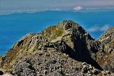 |
| Looking forward towards Chimney Peak, perhaps the most notorious scrambles on the Knife Edge. |
 |
| Even in late June, snow lingers at the top of a glacial cirque. Thousands of years ago, snow and ice occupied Katahdin's slopes year-round. |
The Knife Edge starts off from the very beginning with one of its most well-known - and sketchiest - parts of the hike. Between Pamola Peak and the adjacent Chimney Peak is a hundred foot deep ravine, its walls entirely made of bare rock. The trail goes right down one side and up the other, and both sides are rated as a high class-3 to low class-4 scramble (I would call it high 3 myself). Images of this ravine had me so nervous before hiking Katahdin that I had actually done some pathfinding via pictures online before even reaching the mountain.
While still dangerous, the climb isn't quite as scary in person. Despite the sheer drops on both sides of the peak, the trail is always located above the col, meaning there's never more than a hundred feet of exposure. The rocks are Maine granite, with a lot of traction, and footholds are usually pretty easy to find. For those unfamiliar with scrambling, it's a terrifying prospect, but with a little experience (which one should really have before attempting a climb like this), it's not too outrageous.
The group in front of me, however, didn't have much scrambling experience, and it made for an issue I haven't dealt with on a mountain before: Trail cramming. Due to the dangerous nature of these scrambles, there's really only one way down, so everyone on the mountain moves as slow as the slowest person ahead. There were around six of us on this stretch of trail at the time, and waiting for those ahead meant stopping frequently, often in precarious positions on the side of the sheer rock. We made sure to keep at least a dozen feet away from each other, so that if someone fell, they wouldn't take everyone else down with them.
Once we reached the col, I snapped a few pictures, stowed my poles (which had been more cumbersome than anything on descent), and the slower group let everyone pass. Ascending Chimney Peak seemed much safer than descending Pamola, but scrambling up always is; you're not always looking down, and gravity isn't giving you a boost. Once I reached the top of Chimney Peak I looked back in mild disbelief at what I - and the other climbers around me - had just successfully navigated.
 |
| Looking into the steep upper slopes of South Basin from the col between the peaks. |
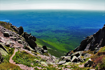 |
| Looking out towards the distant ocean, directly into the intense wind flying over the unbroken forested plains. |
 |
| The inside slope of Pamola Peak. The path I descended runs right down these rocks, marked by hand-sized blue markers (enlarge to view the trail). |
 |
| Looking out to Baxter Peak (Katahdin proper) on the way up Chimney. |
 |
| The view of the Knife Edge from Chimney Peak. Sheer drop-offs on both sides mean one mistake on this narrow, exposed ridge can mean death. |
With the steep scramble peaks behind me, now I could focus on the real fun of the hike: The Knife Edge. When I had first dreamt of hiking Katahdin, I thought of the Knife Edge as a crazy, impossible idea; as my climbing experience grew, hiking it became a must. With thousand-plus-foot drops on both sides, expansive views in every direction, and only a narrow stretch of smooth rock beneath my feet, it was sure to be a mile of pure thrill.
The constant winds coming from the south put a bit of a damper on that thrill, but not enough to make the hike unenjoyable. Massive pillars of lichen-colored granite lined the inside walls of the glacial valley to the north, forming the edges of the narrow, blade-like ridge. The trail beneath me, while unmarked, was easy to follow, as any deviation would lead to a deadly drop. I was so enthralled by my surroundings, so occupied with pathfinding on the endless scramble, and so annoyed by the wind that I didn't even notice the hundreds of feet of needless elevation that the serrated ridge added to my already lengthy hike.
 |
| Some would warn not to look down, but I found the view of the land below too fantastic to ignore. |
 |
| Dry riverbeds, cleared during spring flooding, lead to the upper reaches of the aptly-named Avalanche Brook farther down the mountain. |
 |
| Hamlin Ridge seen beyond the limb of Pamola Peak. |
Curiously, I came across a part of the Knife Edge that seemed the most dangerous to me, yet I had never seen anything written about it online. Rather than climbing loose rock at the top of the cliff, the blazed trail went down and along the inside of the ridge for awhile. Part of this included walking along a sheer rock wall along a little ledge no more than a few inches across. Perhaps most people climb over the ridge here instead of along the trail, but I found it strange that this section isn't more notorious for its danger.
 |
| Walking along the sketchy cliff edge in the shadow of Baxter Peak. Yes, that little crack in the rock is the 'trail'. |
 |
| Other hikers descending one of the small peaks along the Knife Edge, with the flat forests of northern Maine in the background. |
While the Knife Edge's eastern end is clearly defined at Pamola Peak, its western end is more vague. Rather than ending suddenly in some incredible rock formation, it gradually widens and transitions from narrow rock cliffs to wide fields of boulders. Somewhere around this point, the ridge goes from its saw-like ups and downs to a straight uphill climb towards the next summit of the day: South Peak.
FOUR: SOUTH PEAK
"I'm telling you, man, that's got to be the summit!"
All the way along the Knife Edge I had noticed what I thought was the true summit of Katahdin at Baxter Peak. Having seen the photos above, surely you noticed the 'summit' as well. However, the apparent highest point in those photos - and in all the viewpoints from the Knife Edge - is South Peak, the penultimate sub-peak of Katahdin. Located less than half a mile southwest of Baxter, and only about a dozen feet shorter, this minor summit is covered in large, loose boulders, a very different environment than what I had just experienced on Keep Ridge and the Knife Edge.
The trail up the side of the barren South Peak is fairly steep, a consistent uphill climb covering the ~500 vertical feet to the summit area. Navigating the large rocks (without turning an ankle) kept my mind occupied so the climb didn't feel rough; I think my body was just glad to be off of the Knife Edge. Looking backwards, however, revealed incredible views of the Knife Edge, and I stopped perhaps too frequently to look back at where I had come from.
 |
| Looking down to Pamola and the Knife Edge, already far below me. |
As I climbed I watched a small group of clouds forming maybe a mile off the edge of the ridge, but with the intense winds, they approached very quickly. Perfectly level with the mountain, the clouds hit the Knife Edge and mostly dissipated, but a few hung around as beautiful foggy strands. I'm glad I got off the Knife Edge when I did, I thought to myself; even a little cloud could make the rocks dangerously wet and lower visibility.
 |
| A close view of the lower ridge as low clouds collide with the mountain. |
 |
| Remnants of the clouds floating away after impact, obscuring parts of Pamola Peak. |
Near the summit of South Peak, the trail starts to level out, providing at first only views of the barren, rocky high-elevation plateau. Unlike the rest of the mountain, South Peak is totally desolate, without even grasses or small woody plants growing from the cracks in the rocks. The only visible life is in the form of flat lichens growing on the boulders, turning covering their natural red-pink coloring to the purple-grey that dominates the mountain.
 |
| Looking up towards the nearly lifeless South Peak (right of center) and Baxter Peak itself (left of center). Note the meter-sized boulders covering the terrain. |
After a brief pause atop South Peak to grab some food and water, I continued along the final ridge connecting it with Baxter Peak, the true summit and my goal of the summer. While not nearly as narrow or dangerous as the Knife Edge, this ridge did provide excellent views on both sides of the mountain, including glimpses of the Tablelands. The shorter, more popular, non-Knife Edge-traversing ascent climbs the mountain from the southwest, going through the flat, barren Tablelands, and from here I had an excellent view of them.
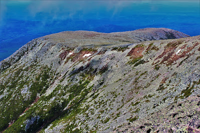 |
| Snow and patches of bushes cling to the slopes of the barren Tablelands, stretching out to the mountain's southwest. |
While not nearly as formidable as the Knife Edge, the ridge between South and Baxter Peaks does run along the top of some of the enormous granite pillar-like structures that compose much of Katahdin's mastiff. While I tried to keep from getting too close to the edge, especially with the ground composed largely of loose rocks, it was incredible looking down at the enormous cliffs and realizing that the broken rocks beneath me were part of the same formation as the striated rock walls thousands of feet below.
 |
| Looking down towards Chimney Pond and the edge of Keep Ridge in the valley. The Dudley Trail, a much steeper approach to Pamola Peak, connects the two over the cliffs. |
 |
| Some of the steep granite formations with Hamlin Peak in the background. |
 |
| Looking out towards Pamola and the Knife Edge. Note more of those fascinating rock formations in the foreground. |
The way that the ridge between South Peak and Baxter Peak sits makes it difficult to see ahead on the way between them. While so distracted by the loose rocks beneath my feet and the beautiful ones beyond the valley, I hardly even noticed my own progress. Before I knew it, I crested a ridge and arrived at the summit: The top of Maine.
FIVE: BAXTER PEAK
"Where's the thingy? Every high point has a survey thingy, it has to be here!"
At long last, I had arrived. After four years of dreaming and weeks of planning, I was finally on top of Katahdin and, more importantly, Maine. I had battled the Baxter State Park reservation system, traversed the Knife Edge, completed my dream hike and made it to the top of the formidable peak. In triumph I dropped my backpack at the summit cairn and, rather than taking a break, began running around taking pictures.
 |
| The summit cairn, caught in a smudge on my camera lens, with Pamola and Chimney Peaks at left and South Peak at right. |
The peak was fairly crowded, and from what I could gather most of the two dozen or so people at the summit had come up from the mountain's west side. I talked a bit with a man and his daughter who had just climbed the mountain; he took my picture with the summit and I did the same for them. The man, a Maine local, had climbed Katahdin eight times, and we talked about the different routes up the mountain and their pros and cons. He approved of my planned route, calling it "the best way to do this mountain". His daughter had some trouble finding the USGS survey marker at the summit, so I directed her to it while he continued to give directions to all the confused hikers at the top.
 |
| The USGS survey marker at the highest point. |
 |
| Katahdin ME, elevation 5267'. State high point 17/50. The northern terminus of the Appalachian Trail somewhat humorously gives the distance and direction to its southern terminus in Georgia. |
I spent the next fifteen minutes of so intermittently eating lunch and taking countless pictures from the true summit with both the wide and narrow-angle lenses. (For brevity's sake, I've excluded most of these from this post). The view was beyond incredible, and the feeling of finally achieving this long-held mountain goal was remarkable. The summit was fairly crowded, but all the day's hikers were surprisingly talkative, so I didn't really mind.
 |
| A look at Chimney Pond. Note the differing terrain on different shores (forest versus rockslide) and the ranger station at upper left. |
 |
| Turner Mountain seen over the limb of Hamlin Ridge, |
 |
| Terrain along the Knife Edge looks scarier from a distance than it does up close. |
 |
| A close-up on Big Spencer Mountain to the west. Despite the hazy appearance, the mountains here are less than thirty miles away. |
 |
| True unadulterated wilderness is rare in the northeast. This shot of swampy pine forest beyond Katahdin's alpine limb encapsulates the wilderness feeling of Baxter State Park. |
One of the most incredible things about Katahdin, in my opinion, was the social environment. It was unlike anything I had ever seen on a mountain before; pretty much everyone there was a 'serious' hiker. I stood around with the group at the summit and we compared stories of Mount Washington, discussed the peakbagging lists we were working on, and everyone got along perfectly. It was us verses the mountains, and that made us brothers. (Curiously, I only saw two women on the mountain all day, compared to several dozen men; evidently mountaineering isn't the hobby to take up if you want to meet girls).
After some time of discussion taking in the view, I left the summit and headed for my next goal: Hamlin Peak. Hamlin Peak was considered an optional target for this hike, and doing it and the Knife Edge on the same day is considered a pretty serious trip. However, I had plenty of supplies and daylight left, and I was in good spirits, not yet exhausted somehow. Hamlin Peak is a good deal shorter than Baxter, and getting to it involves descending into a fairly deep col called The Saddle, so I wanted to start while I still had energy.
SIX: THE SADDLE
"That trail has some of the most beautiful views on this mountain; it's such a shame nobody ever hikes it."
The northwest side of Baxter Peak is very different than the southeastern approach. After a field of very large boulders, the ground is covered in millions of pebbles and rocks, too large to be scree but still dangerously unstable. With gravity pulling me down and each step setting off a mini-rockslide I had to be careful not to turn an ankle on descent; it seemed like the terrain was actively trying to injure me. Nonetheless, the descent had some excellent view of the wide barren Saddle, including a 'forest' of knee-height evergreens, and the isolated mountains to the northwest.
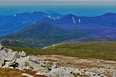 |
| Peaks to the northeast include South Brother (foreground center) and Doubletop Mountain (background left). |
 |
| The Brothers rise over the backside of the Katahdin mastiff, covered in an extensive dwarf forest of firs and spruces no higher than two feet. |
 |
| North Brother (L) beyond Howe Peak (R). The trail traversing the Saddle is clearly visible, heading off-camera towards Hamlin Peak. |
 |
| Looking towards Hamlin from just above the col. |
One of the popular trails up Baxter Peak ascends the steep glacial cirque to the middle of the Saddle, and many hikers ascend this way from Chimney Pond, or make a loop involving the Knife Edge. The trail was pretty well-trafficked as far as the junction, but once I was on the north (Hamlin) side of the col, I would be on my own for the rest of the day. The trail here, while fairly level, traverses a number of different environments, including standard alpine tundra, dwarf forests, and boulder fields, all with stunning views of the surrounding terrain.
 |
| A view of Hamlin Peak from a little beyond the trail junction. |
 |
| Looking out over the valley from its north side. The Basin Ponds and Katahdin Lake are the most prominent features. |
 |
| Bright pink bog laurel (Kalmia polifolia) grows in extensive mats in the wetter areas of the Saddle. |
 |
| Looking back towards the main mountain. Pamola Peak is at left, with the Knife Edge connecting it to Baxter at right. |
 |
| Looking out to the Cross Range and nearby mountains from the trail to Caribou Spring. |
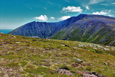 |
| Katahdin from the northwest. The mats of green in the foreground are actually woody plants like bushes and shrubs, growing as tiny self-protecting balls mere inches high. |
 |
| Looking uphill at Caribou Spring, just after my filter broke. The water running across the rocks was the only moisture I saw above the treeline all day. |
 |
| Hamlin Peak, elevation 4756'. Northeast 4k 20/115. Alone on this mountain, I had to prop up my camera for a summit picture. |
 |
| Looking into the treeless North Basin from the summit. Despite its barren nature, geological evidence suggests that North Basin has been ice-free for thousands of years. |
 |
| A view of the descent route: Basin Ponds beyond the limb of Hamlin Ridge. |
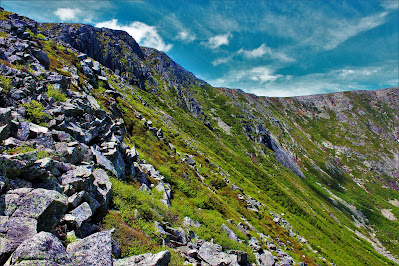
The beauty of Hamlin Ridge is hard to overstate. It's quite nearly as incredible as the Knife Edge, a perfectly symmetrical rocky ridge lined with grasses and lichens with astonishing views into barren valleys on both sides, rugged mountains above, and endless forests below. It was difficult to keep walking - and to keep my eyes on where my feet were going - as I was so captivated by the surrounding landscape. The dreadfully underrated trail gave me the feeling of some fantasy character travelling on a long quest, traversing high mountains and distant lands.
 |
| Looking down the serrated terrain of Hamlin Ridge. |
 |
| Looking back up towards Hamlin Peak (L) and the headwall of the North Basin. |
 |
| Basin Ponds (left front), Katahdin Lake (left rear), and unending forests stretch out beneath clouds almost too perfect to believe. |
 |
| An oblique view of Chimney Pond, with boreal forests on three sides and rocky talus on the fourth. |
 |
| Looking back up the ridgeline to the now-distant Hamlin Peak. Clouds began to move in around this time. |
 |
| A small pond in the North Basin is surrounded by shrubs and bare rock. |
 |
| The trail down Hamlin Ridge pointed almost directly at South Turner Mountain; towards the end it was close enough to be noticeable above the landscape. |
 |
| Pamola, the Knife Edge, and Baxter Peak from the treeline, with the bright green South Basin below. Keep Ridge, my ascent route, is out of frame to the left. |
 |
| Rocky trail below the treeline on Hamlin Ridge. |
 |
| The Saddle viewed above Basin Lake and the extensive evergreen forests surrounding it. |
 |
| Looking up towards North Basin, with Hamlin Peak at left and Howe Peak at right. |

No comments:
Post a Comment