Basin Mountain: Adirondack High Peaks 12/46Saddleback Mountain: Adirondack High Peaks 13/46
With the Catskill High Peaks complete, I've wanted to focus more seriously on the Adirondack High Peaks this summer, although their considerable distance - and the considerable price of gas - makes such hikes difficult. I had conceived of a large overnight trip that would bag six high points in two days, but lacking the time and proper supplies for such an endeavor, I scaled down my plans to a day hike with a two to three summit itinerary. I had taken the week off to climb Katahdin, so I figured a warm-up hike earlier in the week would be a good idea anyway, so Monday I headed north to tag some more peaks in the Great Range.
My plan for this day was to head in from the Garden trailhead and follow the Johns Brook trail, mimicking the hike I took up Mount Haystack a year earlier. After this I would ascend Basin, Saddleback, and hopefully Gothics before descending along the Ore Bed trail. This involved crossing an easement through Adirondack Mountain Reserve land, which is always crowded and closely patrolled, which I wasn't a huge fan of. Still, it was the best way to grab a few peaks for the month, so after getting a late start, I headed down the by now familiar path.
I arrived around 9:30 AM, and the crowded Garden trailhead was already packed; I got the last spot open and started my hike quickly. It looked like most of the other hikers were going up nearby Big Slide Mountain, and the trails were pretty empty most of the way over. I ran into a ranger near Bushnell Falls and we talked a bit; I told him my intended route and he made sure I was comfortable with my level or preparation. I was only in sneakers, and the hike would involve some scrambling, but I wasn't too concerned, having done Giant, Algonquin, Iroquois, Marcy, and Haystack in sneakers as well. This hike would turn out to be very different from them.
 |
| A small waterfall on the upper reaches of the John's Brook. |
I headed up past Slant Rock and up the Shorey Short-Cut towards the Range Trail, which would take me to Basin Mountain. Before I got to anywhere I had never seen before, however, I arrived at a south-facing overlook just over the crest of the trail. I had been here last June, taking the Short-Cut by accident on the way back from Haystack. At the time, I was lost and dealing with a flooded backpack so I couldn't really enjoy the view. Now, however, with the bulk of my hike (and elevation gain) still ahead of me, I stopped to take some pictures and appreciate the overlook.
 |
| Looking out towards Sawteeth and the lesser Adirondack peaks to the east. |
 |
| A small hill below Mount Haystack juts out before the wide, forested Ausable Valley. |
 |
| Looking up to the barren Mount Haystack (and Little Haystack at right), far above the overlook. |
After stopping at the overlook for awhile I climbed down quite a bit - around 300' - to the col between Basin to the north and Haystack to the south. The ascent of Basin wasn't too bad by Adirondack standards, with a few slides and scrambles but nothing too extreme. It was fairly steep, around a 25% grade, but I kept hydrated and reached the top without incident, albeit slower than I had hoped, passing several other groups on the way up.
 |
| Basin Mountain, elevation 4826'. Adirondack High Peak 12/46. |
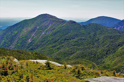 |
| Looking over to Haystack, just a little bit higher than my current elevation with Skylight at right. |
 |
| The south ridge of Basin Mountain juts out over the hills and lakes of the Ausable Valley. |
 |
| Looking west towards Skylight (L) and Marcy (R) over the limb of Mount Haystack. |
 |
| Swamplands above Upper Ausable Lake fill the valley to the south. The valley is cris-crossed by private hiking trails owned by the Ausable Club. |
 |
| Peaks here include Hoffmann Mountain (far left) and Boreas Mountain (far right). The most distant hills are near Lake George, some fifty miles to the south. |
 |
| The lower summits of the Sawteeth stretch out against a ninety-mile mountain view. The farthest peaks visible here are located in southern Vermont. |
 |
| A focus on Mount Colden, with Mount Marshall at the end of the MacIntyre Range to its right. |
 |
| Gothics and Giant (L) seen through stunted fir trees at the summit. |
 |
| A closeup on the lower Sawteeth (foreground), Nippletop (midground), and the distant southern Green Mountain (background). |
When I reached the summit I wasn't alone. There was a small group up there and we talked about the climb up and how crowded the trailhead had been; they took my picture at the top and we both stopped for lunch. A few minutes later a much larger group of younger hikers arrived; they criticized my attire and hiking experience, which was a little offputting. Most people on the trails are very kind and cordial; for some reason, at the risk of sounding much older than I am, the rudest hikers I've run into are always in their early to mid 20s. I didn't finish my lunch, but headed off the summit after taking some pictures, determined to beat their group to Saddleback.
 |
| Looking south towards Second Pond and the foothills in Hamilton County. |
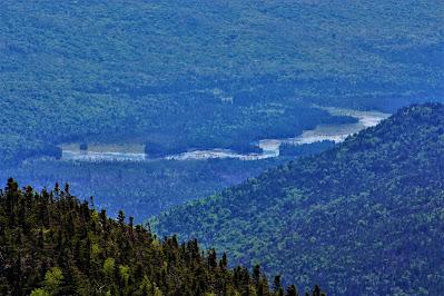 |
| A closer view of flooded swamplands along the Ausable Creek. June is mud season in the Adirondacks, and the trails were in some places just as flooded as these swamps. |
 |
| A close view of Mount Marcy, its summit fairly crowded on a beautiful spring day. |
 |
| Small but prominent peaks dot a forested unnamed ridge on Haystack's southeast flank. |
 |
| Gothics features prominently from the north side of the summit, flanked by Giant Mountain to the left and Rocky Peak Ridge to the right. |
 |
| Pyramid Peak, while not a High Peak due to its small prominence and isolation, is an easy-to-spot side-peak of the Great Range. |
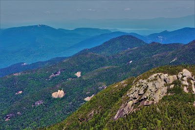 |
| Saddleback Mountain, my next target, is at lower right here, with the Wolfjaws in the middle and Hurricane Mountain at upper left. The water in the background is Lake Champlain. |
 |
| Looking out over Keene Valley, carved by the John's Brook through the High Peaks region. The Jay Mountains are at upper right, and the Garden trailhead, where I started, is at bottom right. |
 |
| A prominent cliff somewhere deep in the valley, easily over a hundred feet tall. |
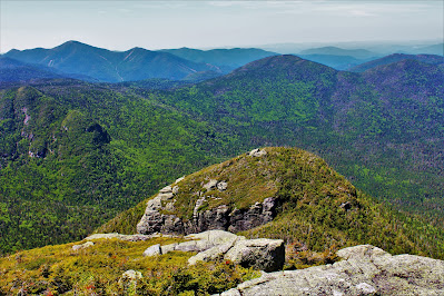 |
| A northwest view towards Basin's smaller, barer second summit. The MacIntyre Range is at upper left, with Table Top Mountain right of center. |
On the way down Basin's northeast slope, I began to wonder if I wasn't somewhat unprepared for this hike. Like most of my hikes this was a relatively spontaneous endeavor, and I hadn't studied the mountains or trails too much beyond 'where do I turn'. Descending Basin meant dropping down a lot of very sketchy scrambles, rockslides, and ledges, which given the muddy conditions and my less-than-ideal footwear was pretty dangerous in itself. After awhile I reached an overlook that pointed towards Saddleback, and I discovered I had definitely bitten off more than I could chew.
 |
| Saddleback is left of center while Gothics is center right. The trail up Saddleback climbs straight up the rockface visible here. |
 |
| A view north towards Whiteface (L) and Big Slide (center), a more popular hike on this day. |
This overlook provided a view of Saddleback and Gothics, my next two stops on the hike. Gothics was optional, but Saddleback was a requirement; there are no trails descending between Basin and Saddleback, meaning I would have to go over it, or backtrack, to get back down. To my dismay I spied a hiker ascending on the exposed rocks of Saddleback, the trail ahead of me, and had trouble believing what I was seeing. The trail seemed to climb directly up the side of a cliff, exposed on the side of the mountain. It looked like the sort of climb that would require actual gear, ropes and climbing shoes and the like.
I had none of these, and the knowledge of what was ahead began to fill me with dread. If I went forward, I would have to climb over Saddleback to get back to the trailhead. If I went backwards, however, I would have to climb past the group that had just questioned my hiking ability, and that was unacceptable. With a nauseous stomach and a lot of prayer I inched on towards Saddleback.
 |
| The class-4 scramble up the Saddleback Cliffs. Yellow/white blazes mark the trail. |
Once I reached the base of the apparently notorious Saddleback Cliffs, I felt a bit better. It was definitely a serious climb, a class four scramble with limited exposure that I would have to do in muddy sneakers. However, there were a number of small hand and footholds that I hadn't been able to see from farther away. It was still by far the most dangerous climb I've done so far, and certainly sketchy given my inadequate gear, but not as impossible as I had feared. Soon I was at the top of the mountain, by now feeling accomplished rather than nervous.
 |
| Saddleback Mountain, elevation 4528'. Adirondack High Peak 13/46. |
 |
| A view over the Ausable Valley, this time with Basin cutting across the foreground. |
 |
| Looking back towards Basin, its slopes covered in long, impressive slides. Haystack is visible just over the limb at left. |
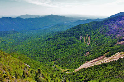 |
| Upper Ausable Lake is visible in this wide shot of the whole valley. |
After celebrating my well-earned triumph, I left Saddleback's summit pretty quickly. The descent went very smoothly, and I would recommend any future hikers to ascend from the east side of the mountain, unless you really want a challenge. Partway down I decided to skip Gothics; while I was confident I could climb its long rocky scrambles, doing so would put me back at the trailhead around sunset, and not back home until very late. I was leaving for Maine's Katahdin the next day and figured a little bit of down time would serve me well between two major hikes. I would have to re-climb Gothics to do Sawteeth eventually anyway.
From the col between Saddleback and Gothics I descended via the Ore Bed trail, which runs parallel to the Ore Bed Brook. An original overnight concept called for me to stay at the Ore Bed lean-to farther down this trail. The trail also runs along the Ore Bed Slide, a medium-sized rockslide covered in moss in some areas, but mostly barren. As slides are incredibly dangerous, a long section of steps and ladders covers the steepest parts of the descent, making for relatively safe hiking and excellent views of the adjacent slide. Along here I ran into a hiker who was just finishing her second runthrough of the 46 High Peaks, a fairly impressive accomplishment to someone just a quarter of the way through.
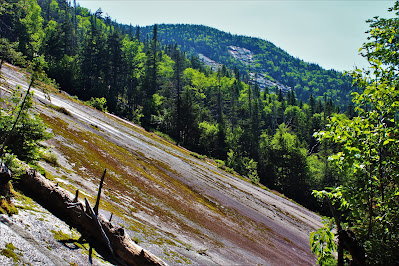 |
| Looking across the slide towards the limb of Saddleback Mountain. |
 |
| Gooseberry Mountain is at left; Big Slide is in the background at right. |
 |
| Looking up one of the series of steps along the bare, foreboding slide. |
I got a little turned around at the base of the slide, following the fledgling Ore Bed Brook instead of the trail, and slightly injured myself when I fell through some debris. Other than that, the rest of my hike out was uneventful, following the by now quite familiar John's Brook Trail. The trails near here were quite crowded, with a lot of people heading in, presumably to spend the night at the AMR's lodges deep in the valley. I made good time, and there was still light in the sky by the time I got home, ready to prepare for the summer's capstone climb: Katahdin.


No comments:
Post a Comment