Mount Esther: Adirondack High Peaks 10/46Whiteface Mountain: Adirondack High Peaks 11/46
Having completed the nearer, safer, and less-numerous Catskill High Peaks back in January, I set my sights this summer on a more lofty goal: The 46 Adirondack High Peaks. The quest to climb all Adirondack peaks with summits above 4000 feet predates the Catskill 3500, the Northeast 111, and other goals as one of the oldest peakbagging organizations in the country. While the three-hour one-way drive and long, strenuous nature of many Adirondack hikes makes this more difficult, I find it a logical next step in my climbing ambitions.
Whiteface and Esther in particular are the northernmost High Peaks, located twenty miles north of Marcy, Algonquin, and the other major mountains of the state. Nevertheless, with a summit elevation of 4867', Whiteface is the fifth-highest point in New York. Whiteface was made famous during the 1980 Olympics, where the ski slopes on its southeast face captivated the world's attention and brought fame and ruin to athletes from around the globe. It remains an incredibly popular ski area today.
Most people ascend Whiteface Mountain via Route 431, a highway that winds its way to the summit. With an impressive eight-percent grade, the tolled highway is the highest road in New York, at least during the summer when it's open. Driving to the summit, however, isn't nearly as much fun as hiking in my opinion, especially when Mount Esther, another High Peak, is located farther down its slope. Hoping to beat the summer crowds, I chose a pleasant day in late May, the earliest hike I've yet done in the Adirondacks, to make my bid for the top.
I parked at the Atmospheric Sciences Research Center, a station near the base of the mountain that studies the climate in the area. (This center, plus the tower at the summit, allows forecasts for Whiteface far more accurate than the other HPs). While the trailhead is located here, it isn't well marked, but staff at the research station kindly directed me to the path.
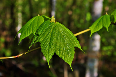 |
| Young, bright leaves of the striped maple (Acer bicolor) just starting to emerge. |
 |
| A view up the unrelenting Marble Mountain Trail. |
The first mile or so of this hike was by far the most grueling. It always takes my body about a mile to get 'into the groove' and accept that fact that I'm suddenly being active. In this case, that mile was the Marble Mountain Trail, a perfectly straight line at a 25% grade, which with the spring meltwater doubled as a creek in many places. I think this trail follows an old ski slope; it certainly wasn't built for hiking. This non-stop grind was a bit of a shock to my asthmatic lungs, and a number of large concrete blocks along the sides of the trail were very helpful, providing welcome respite and the only dry spot to sit on. Soon, I was as the top of Marble Mountain, covered in sweat and bugs and treated to a wonderful view.
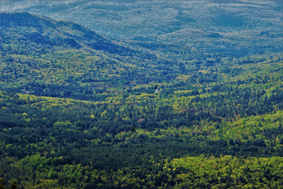 |
| A fantastic view of expansive spring forests with no civilization in sight. |
 |
| The Hungry Trout, a hotel at the base of the ski resort, is one of few manmade interruptions visible from Marble Mountain. |
 |
| Strong humidity made Giant Mountain, a mere sixteen miles away, seem impossibly distant. |
 |
| Serviceberries in bloom at the top of the mountain. |
 |
| The full east-facing view from the overlook. |
 |
| A large concrete block, probably the remnant of some long-gone structure, with my poles for scale. |
At this point I was somewhat concerned; I knew I still had another half-mile of elevation gain, and at least eight miles, left in the day. I was pretty winded from the comparatively mild hike up Marble Mountain. I hoped that my body would soon switch into 'hiking mode' and stop acting so pathetic.
Thankfully, I rounded the corner and found just what I had hoped for: Scrambles. Although more dangerous, the scrambles and rockslides common in the Adirondacks make for delightful hiking. Each one is a new problem to solve: You have to figure out which way up is the safest, which rocks will hold your feet, which trees will hold your weight, and how on earth you'll get back down. This keeps the brain engaged and breaks up the altitude gain. I climbed the next two thousand feet of elevation and hardly felt it.
Trails were, as expected, incredibly muddy. Spring is mud season in the Adirondacks, and to best protect the delicate alpine environment, hikers are advised to hike through the mud, rather than around it. On a day like this, however, there wasn't much of a choice. In many places I had to double check to make sure I was following the (unusually poorly-marked) trail, rather than a river or stream. By early June, this mud breeds millions of tiny biting flies that sour any spring hike, and I was glad to have made it up before fly season began.
 |
| A number of small structures were located along the trail, even at elevation. They might be intended as shelters, but I wouldn't sleep in there unless circumstances were dire. |
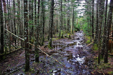 |
| More muddy conditions along the trail. |
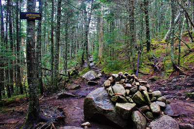 |
| A large pile of rocks marks the junction with the Esther Mountain trail. While not really a herdpath, the trail isn't maintained or marked by the state, and the sign at upper left warns of that. |
From here I turned off up the Esther Mountain trail. Hiking Esther added a two mile sidetrip to my hike, but it meant bagging another High Point and justified the day's six hours of driving. It also meant climbing over a second smaller peak, Lookout Mountain. There were a lot of ups and downs on the way to Lookout, and the terrain was often swampy despite the altitude. Soon I reached Lookout Mountain and, despite a limited overlook, questioned exactly how appropriate its name was.
 |
| Morgan Mountain, to the northeast, tops off six hundred feet below Lookout Mountain's 4085' summit. |
 |
| Catamount Mountain peeks out beyond Esther's north slope. |
 |
| Looking out towards Fern Lake (a mere twelve miles away) in the morning haze. |
 |
| A view of my goal, Esther Mountain, two hundred feet up and a half mile out. |
I didn't linger long at lookout, eager to reach Esther and continue on with the day. I was working with an artificially tight schedule, and was already running behind where I wanted to be. Thankfully the trip to Esther was pretty simple; the elevation gain was gradual, and aside from some snow and mud along the trail, I reached the summit shortly.
Esther Mountain is somewhat unique among the High Peaks. Not only is it the northernmost peak over 4000 feet, it was, until the renaming of East Dix in 2014, the only HP named for a woman. The mountain's name honors Esther McComb, a fifteen year old girl who was the first person recorded to reach the summit in 1839 while climbing Whiteface. The summit, buried in dense fir trees, features a plaque honoring her, limited views of Whiteface, and a LOT of toiler paper. Apparently it's some unwritten rule that Esther's summit is the bathroom of the High Peaks.
 |
| The monument to Esther McComb embedded in granite at the mountain's highest point. |
 |
| At the summit, with Whiteface in the background. |
 |
| A close shot of the facilities atop Whiteface. In addition to the highway, the summit boasts an observation tower, weather station, and café. |
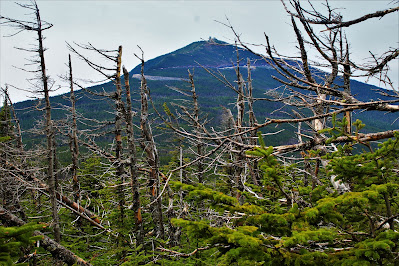 |
| Whiteface looming over dead trees in a swampy area below the summit. |
I made pretty quick time descending Esther and returning to the junction, although it seemed a longer trip down than I remembered going up. I ran into my first other group of the day, two guys from Jersey who had finished Esther and were going for Whiteface and seemed a bit discontented with the hike. At the junction I loaded up on calories and electrolytes in preparation for the run to the summit; I had almost a thousand feet of gain to go, some of which would be without the protection of the trees.
The first mile or so wasn't too bad, a lot of level ground and a bit of up and down for awhile. The only problem here was that some portions of the trail were flooded to extreme extents; thankfully my boots were in good condition so I could just plow through the water, instead of wasting time figuring out how to get around it. Farther up, some of the simple scrambles from before returned, which was a good workout for the arms and the brain. I crossed a few of the ski slopes, all bare and swampy in the spring, before pushing on towards higher, hopefully drier ground.
 |
| The trail goes straight and the river turns right, though I'll admit it was hard to tell the difference. |
 |
| Looking southeast down the ski slope, beyond the alpine taiga and into the Sentinel Range. |
 |
| Some of the ski infrastructure, sitting empty for the season among meltwater puddles. |
The trail steepened as the summit got closer, and the trees around me began to shrink as the altitude increased. I soon stumbled upon a small overlook, just below the spot where the trail crosses the summit road. Foolishly, I only stopped for a handful of pictures here. There would be far better views at Whiteface's summit, I reasoned, and I could stop here for photos on the way back if I made good time. As it turned out, that wouldn't be so simple.
 |
| The view east, over the foothills of the Adirondacks. |
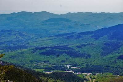 |
| Some of the ski infrastructure in Wilmington made it into this shot. |
 |
| Ski trails on Bear Den Mountain, a sub-peak of Whiteface, sit beneath the jagged summits of the High Peaks. At least fifteen High Peaks, including Marcy at far right, are visible here. |
From here I headed up to the point where the trail meets the road. Rather than truly crossing the twisty highway, the path merely touches it for a moment before diverging. The trail pretty directly follows a ridgeline that's too steep and too exposed for cars to reasonably climb, so for a more direct route to the top it made the most sense to just continue on.
Snow really began to become problematic around here. While patches of snow and ice were scattered around the woods above 4000', there were large quantities of both here. The twisty road to the summit is in many places elevated above the mountain's natural topography, and the trail goes right along the bottom of a stretch probably twenty feet above. All the snow that had collected on the road sloughed off when the spring melt began, and most of it ended up on the trail, where the shade of the forest kept it nice and cool. Nevertheless, I expected snow to become a problem at some point today, so I worked my way around it and up to the road.
 |
| A view of the ~20' berm at the edge of the road, above the trail. |
 |
| Snow piled below the road was four to five feet deep in some places. |
Climbing above the road was beautiful, as though everything had changed. Above the road, the trees were stunted by altitude, allowing expansive views of the land below and what remained of the mountain above. There were some incredibly sketchy parts here, scrambles covered in slick, melting ice; I worked my way above them easily, but couldn't help but wonder how I would pass them getting down. At the end of the icy scramble was a beautiful view of the valley and the ride I was on, and I took out my camera to get some pictures.
This was where things went sour. My camera has been on the fritz since getting caught in the rain on Mount Rogers last week. I was throwing error codes claiming the shutter was broken, but after drying it out, it was working properly. Despite taking extra care of my camera on this hike, and despite the total lack of precipitation, it decided to inadvertently die. As these things often happen at the least convenient of times, it died just as I was getting above the trees, spitting distance from the summit after four miles of relatively boredom. I had gotten out all my anger at the camera back in Virginia, so I just sighed, stuffed it in my backpack, and continued on my way.
 |
| Lookout Mountain and the flat plains of the North Country. The shutter failed partway through this final picture. |
 |
| Switching back to my phone: A view of the ridgeline from the highway's edge. |
 |
| Looking up towards the summit. Note the steep drop at left; I didn't realize this while planning the trip, but the trail to the summit follows the very edge of a great bowl-shaped valley on the peak's southeast slope. |
There were pretty great views the whole way up, which perhaps distracted me from the distance I was covering. Soon, I was at the summit. I avoided the complex of buildings at the top and headed straight for the highest ground, stopping to eat lunch and grab some pictures. There were maybe two dozen people there, all of whom had cheated driven up in their cars, and some staff manning the facilities.
I talked a bit with a ranger at the top; he told me I was only the second person to summit all day from the north side. This surprised me a bit due to the fantastic weather, but it was still fairly early, around noon, and other hikers may have started later. He took a picture of me with the summit sign (I was struggling to take one myself) and told me a bit about the facilities. The road to the top is closed during the winter due to snow, and today was apparently the first day all year it was open. They expected a big rush on the coming weekend, and I was glad I chose to climb on Friday instead of Saturday. I thanked him, finished my lunch, and wandered around a bit.
 |
| Looking out over the extensive High Peaks region. Lake Placid is the large body of water at left. |
 |
| Visitors along the rocky summit ridge. |
 |
| A picture in front of the lake and summit sign. |
 |
| A better version of the above photo, with no evidence of people in it. |
 |
| Looking west towards Moose Mountain and the flatter lands beyond. |
 |
| A southwest-facing panorama from the summit. |
The treeless summit ridge had two lobes to it. The main lobe, or true summit, was home to the all the buildings, the summit sign, the observation decks (above the treeline?), and all of the main attractions. The second, farther lobe was a bit shorter, with some of those quarter-operated lookout devices and a bunch of Canadians posing for photos (mostly from Quebec; I think the border reopened somewhat recently). I headed over for more pictures after my lunch was finished.
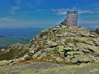 |
| A view of the main summit from the second lobe, with the tower and weather station. |
 |
| Foothills to the west, beyond the main summit. |
 |
| Looking back the way I came over Lookout Mountain (left of center). On clear days, the Monteregian Hills in Quebec are visible from here, but the humidity was too much for that today. |
 |
| East-facing panorama from between the two lobes. |
It seemed that the longer I lingered, the more people showed up, so I soon departed and began my descent. Coming down from the summit was no quicker than ascending it, at first because I wanted to stop every five feet and take a picture. Perhaps if my camera hadn't broken, I would never have made it down! I was surprised how close the trail came to the very edge of the steep ridge, and I imagined that in the winter - which in the Adirondacks runs from late October to early May - this hike would be far more dangerous than it was now.
 |
| The only northwest view all day shows Route 431 as it winds up the mountain and the unending foothills beyond. |
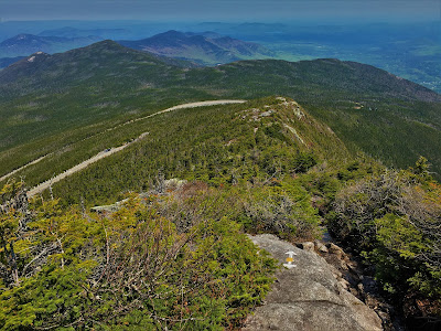 |
| Looking at the trip I had taken. The ridge towards the summit is in the foreground, with Lookout Mountain at center and Esther at left, the trailhead hidden behind them. |
 |
| One last farewell look towards the summit and impressive ridge. |
On the topic of wintry dangers, I soon came across those icy areas again. Ice and snow are the most dangerous in warm weather; they become too weak to reliably support your weight and too slippery to get a good grip on. With proper equipment and knowledge, it's far safer to hike in snow and ice at 0° F than at 40° F. The temperature on this hike was closer to 60° F. At several points I fell through snow that seemed to be deep, but was actually just a few inches atop a feet-deep cavity. Thankfully none of the drops were deep enough to injure me, but these incidents - and the caution taken to avoid them - made for a more gradual descent than I would have liked.
These are often referred to as 'monorails'. When a trail is frequently hiked over the winter, the snow that falls on it gets compacted and often turns to ice. In the spring, the lighter surrounding snow melts easily, leaving the behind the dense compacted ice covering the trail. At high altitudes, the forest is often too thick to go around the ice, and hikers are faced with problems in situations like these where crampons aren't quite justified but boots and poles aren't quite safe enough. To make matters worse, these monorails formed on scrambles, which already require a good deal of caution and full-body hiking.
I eventually figured out a way down by stretching my legs across the trail on the tiny chunks of turf on both sides, praying that they wouldn't give out. I soon made it back to the highway and, after traversing the icy trails immediately below it, was out of the danger zone.
 |
| Looking up the highway, carved through hard Adirondack rock. I could watch plenty of cars come and go as I hiked this portion of the trail. |
 |
| A much smaller, safer monorail well below the highway. |
Returning to the car from here was pretty quick going. The heat of the sun had helped to dry out some of the moisture, and although the trail remained pretty muddy, it wasn't quite as bad as it had been just a few hours earlier. The descent was a bit rough on my knees and ears; I went down three thousand feet in just over an hour, only half the time it had taken me to climb up. Descending from Marble Mountain was particularly fun; what had been a ruthless grind on the way up was now a fun obstacle course sprinting down the rocky path.
Somehow I missed the sidepath that leads to the parking lot and continued following a snowmobile path. This path leads out to the highway, a half mile from the trailhead, and though I soon realized my mistake, it took some time to convince myself of it. Not wanting to add any more time to my trip, I peeled off and bushwhacked the way back to the trailhead, adding just a tad more adventure to the end of a successful hike.


No comments:
Post a Comment