Guadalupe Peak, elevation 8751'. Texas highpoint, U.S. state highpoints 34/50. Solo ascent via Pine Springs. 9.1 mi, 2986' gain, 4h6m RT.On the seventh and final day of my great midwest highpointing trip, my alarm went off at 4 A.M. sharp. I was asleep in my car at the Pine Springs Rest Area in west Texas, where I had arrived after yesterday's ascent of Black Mesa. As soon as I was awake enough to turn the alarm off, I started driving south, and soon found myself at the deserted Pine Springs parking area. Guadalupe peak is located in the Guadalupe Mountains National Park, and most trails in the park were currently closed due to wildfire risk. There was only one other car in the parking lot when I arrived.
Guadalupe Peak was the hike on this trip that had me the most worried. The peak involved a significant amount of elevation gain and a long hike at a higher elevation than I had ever reached before, and I was climbing the desert mountain in August. I figured that the best approach to avoid becoming dangerously dehydrated was to ascent the mountain in the dark via headlamp. I had never hiked by headlamp before, so that made me a little nervous too.
I could see one other group, presumably the owners of the other car, some distance farther up the mountain, and it made me a little relieved to see that I wasn't the only one here. After readying myself and getting the headlamp properly secured, I began my ascent.
While I had hiked Black Mesa in the desert the previous day, the conditions here were totally different. Prickly-pear cacti dominated the steep, rocky environment, each with the eponymous red fruit growing off its pads. Wildflowers and juniper trees also dotted the area, as did aloe plants, all dripping with dew and moisture from the previous day's rare storms. At the higher elevations, there were more pine trees and even some deciduous trees more typical of the east coast.
 |
| A wild aloe plant along the trail, lit by headlamp. |
For the first mile or two, the trail switchbacks up the steep eastern face of Guadalupe Peak. With no context to the mountain in the total darkness, it seemed like I was climbing steep, narrow, and rocky trails back and forth for eternity. The trail itself wasn't particularly challenging, just very tiring and a little monotonous. I kept track of the headlamps above me as I climbed and, later on, the headlamps of another group that was starting to climb below me.After what seemed like forever, I made it to the top of the slope, a point at which the trail turned into a small canyon filled with damp pine forests. From here I could see the lights of Carlsbad to the northeast, and I paused for a moment to rest. I thought about how crazy it was that I was actually out here, thousands of miles from home, in a landscape and environment that I had only ever seen in movies and on the internet. Something about those distant city lights were so compelling. They represented thousands of people whose lives in terms of location were so radically different than my own, but in other ways so very similar.
 |
| The lights of Carlsbad from the top of the 'wall'. The lights at lower right are from the rest area, and some stars are visible in the sky. |
As I turned into the canyon section of the trail, what struck me immediately was how silent it was. There was no wind in this insulated area, there were no other hikers anywhere nearby, and I couldn't see beyond the range of my headlamp, around twenty or thirty feet. I wasn't as frightened as I thought I would be as long as I kept moving. I also noticed that, when I stopped and stood still, I could hear the echo of every little noise I made off of the canyon's far wall.Time seemed to fly by in the dark, and before I knew it I was above the treeline. By now, the sun was starting to rise, and I eventually turned off my headlamp. There was a little bit of scrambling here, and the trail wrapped around great white rocks and shrubs. The wind was picking up, and fog was starting to rise out of the desert floor, by now far below me. I stopped at a turn here and had what I could only describe as a nearly spiritual moment looking up at the stars in the sky and the lights on the horizon and the silhouettes of the different plants around me.
After two hours I finally came out on top. The summit of Guadalupe Peak is marked by a great metal triangular obelisk with various plaques, but it was still too dark out to take a picture. The sky was still a dark grey, but the horizon was starting to turn a deep red with the sunrise. There was a couple on the far side of the rocky summit ridge, evidently the group I had seen ascending above me, but we stuck to our own respective sides for awhile.
 |
| The view south before sunrise towards a peak known as El Capitan. |
 |
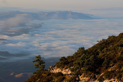
| Dense fog covered the desert floor in every direction. |
.JPG) |
| Fog and undercast below the colorful sunrise. |
Unlike the conditions on ascent, the summit was swept by strong winds that blew up from the valley, bringing with them waves of fog and cloud. It was surprisingly cold for Texas in August, likely exasperated by my sweat-dampened clothes and the storms from the previous night. As I stood and enjoyed the environment, the sun began to rise in what was the most beautiful sunrise I think I've ever seen.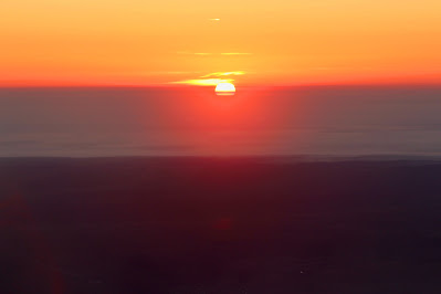.JPG) |
| Sunrise behind the clouds from the summit of Texas. |
.JPG) |
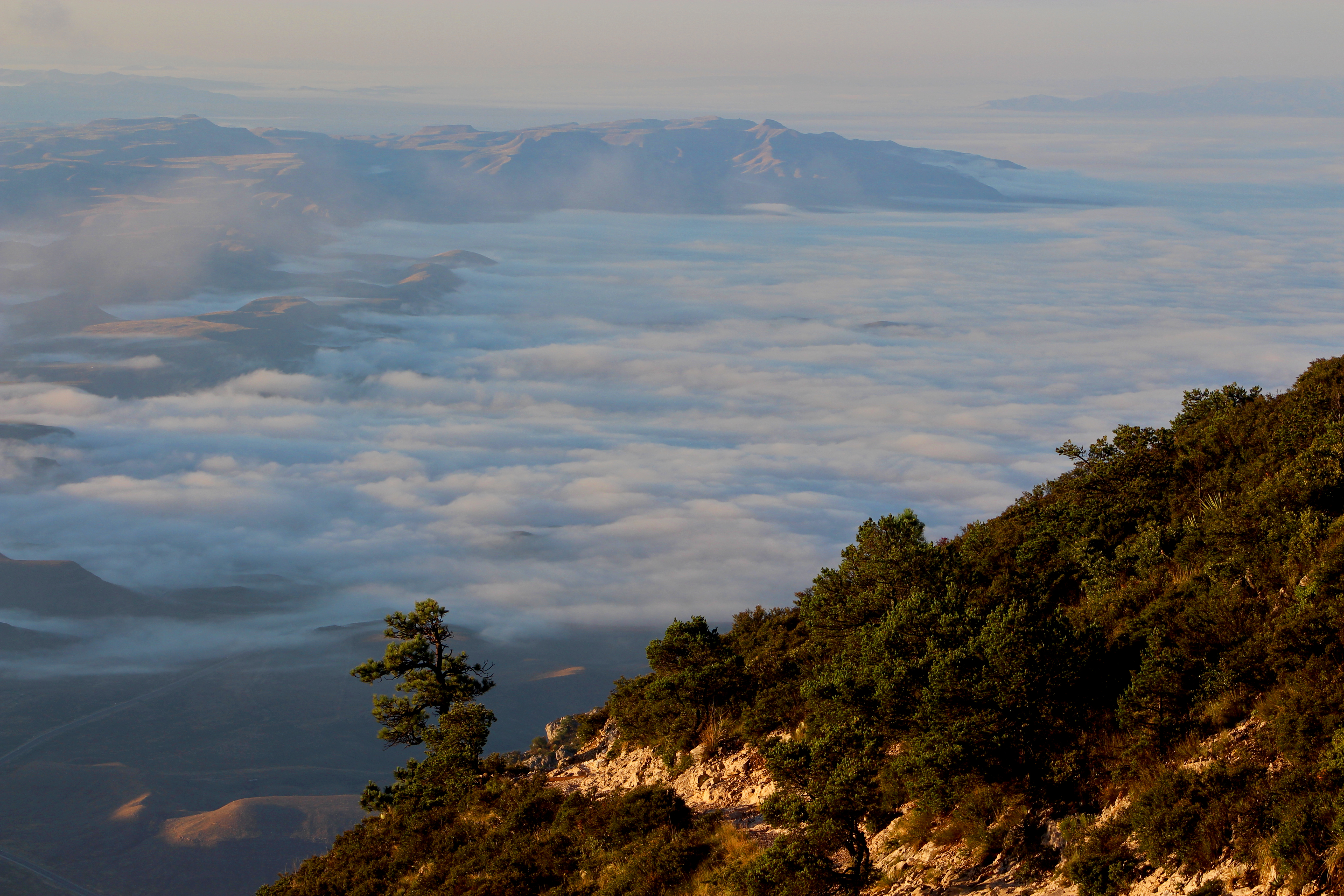
| More foggy undercast in the distance. |
 |
| Windswept clouds fly by the rocky mountainside below. |
After awhile, the couple on the other side of the summit headed over to my side to watch the sunrise and we talked a bit. The man, remarkably, lived in the same city as my father, and had a cousin who lived in my own hometown; his partner had grown up in north Jersey near my childhood home. With a number of strange coincidences already we talked for quite awhile at the summit, and we took each others' pictures with the summit obelisk. We talked about highpointing for awhile, and he was far more experienced than I. He gave me some advice for Whitney and Rainier when I get to them.
.JPG) |
| Occasional pine trees dot the steep, rocky upper slopes of Guadalupe Peak. |
 |
| Undercast and mountains beyond the trail. |
I found the descent to be quite different from most hikes, as I had ascended in the darkness. Now on the way down I was seeing everything for the first time, to a backdrop of sunrise and foggy landscapes. Much of the upper parts of the mountain were covered in pine forests, which were still cool and damp in the early morning, shaded by the mountain's ridge. Farther down, the cacti and junipers began to reappear, although now I could see the extraordinarily deep canyons that I had unknowingly climbed through. As I looked out through the fantastic landscape, I imagined that this park would be worth a visit even if I had had no plans to hike.
 |
| Pine forests along the trail, looking giving a very un-Texan feel to the environment. |
.JPG) |
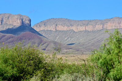
| View of the surrounding mountains and canyons on descent. |
 |
| Looking out over the flat, arid landscape below. |
When I reached the switchbacks again, I realized just how far I had come in the dark morning. The climb down involved a seemingly endless series of steep switchbacks that climbed up over a thousand feet of elevation. I thought to myself that I was glad I had ascended via headlamp, because if I had been able to see what laid ahead, I would have been significantly more discouraged on my climb. I passed a few other groups on their way up, and while I still thought it was a little crazy to climb in the late morning, the storm the previous day meant the temperature was still reasonable now.
 |
| Looking down onto great canyons beneath the 'wall'. |
 |
| From farther down along the mountain, the hills to the east seemed much more significant than they had from the summit. |
 |
| A prickly pear growing from the cactus of the same name. |
Once I was back at the car, I unloaded my pack and got ready to head out. Although my phone was quite nearly dead, and I needed it for directions, I felt that a moment like this deserved some accompaniment, so I listened through the Halo Reach soundtrack on my way out of the mountains. The drive back towards civilization was quite beautiful, as I drove parallel with the Sierra Diablo all the way south to the town of Van Horn. On the way, I drove past Blue Origin's spaceport, and while I couldn't get anywhere near the infrastructure itself, I had to stop and take a picture with the sign.
 |
| One last shot of the Guadalupe Mountains on my way out of the park. |
 |
| The steep canyon walls of the Sierra Diablo along Route 54. |
 |
| Signage at Blue Origin's spaceport. |
Soon I made it back to Route 10, the highway I would follow all the way back to college in Pensacola. This was a roughly eighteen hour drive, which I planned to make all in one shot. Much of Texas is very flat and very brown, and it was a little boring driving the entire length of the state in a day. Traffic in San Antonio at rush hour was a little crazy, and my car's thermometer topped out at 107 degrees (at 70 mph). As it turns out, however, waking at 4 AM, hiking nearly ten miles, and then driving over a thousand miles, isn't the smartest idea. I ended up pulling over at a rest area near Mobile AL to rest for a few hours, but still made it back to college at 7 AM the next morning, concluding a miraculously successful and enlightening seven-day solo road trip.


.JPG)
.JPG)
.JPG)


.JPG)

.JPG)

.JPG)


No comments:
Post a Comment