Black Mesa, elevation 4973'. Oklahoma highpoint, U.S. state highpoints 33/50. Solo ascent via Black Mesa trail. 8.9 mi, 735' gain, 2h43m RT.Most people would balk at the idea of hiking in the desert. Doing so in August may well qualify you as insane. It's not a diagnosis I would disagree with.
It was the sixth day of my great solo midwest roadtrip, focused on bagging a number of state highpoints. For only the second time on the trip, I woke up in a hotel, and got to enjoy an actual bed and a shower. I was out by around 5 AM and began my drive from the city of Guymon OK to the trailhead for the state highpoint, even farther to the west at the end of the Oklahoma Panhandle.
Black Mesa is located right on the border between Oklahoma and New Mexico in a desert environment. Due to extreme heat in the summer months, it's recommended that hikers begin their ascent before sunrise. Warning signs at the trailhead actually inform visitors that if they're starting their hike after 10 AM, they're already too late and should go home. I wasn't planning on turning around any time soon.
The sun was just starting to come up when I arrived, which meant it was still later than I had intended, but it also meant that I wouldn't need to use my headlamp. Upon stepping out of the car, I promptly walked into a cactus, something that I wasn't accustomed to and that I made sure not to repeat on the course of my hike. The terrain here was, like much of the places I had been that week, beautiful and completely new to me, with great rocky cliffs rising above an open, barren plain.
.JPG) |
| Cliffs at Black Mesa at sunrise near the trailhead. |
I began the hike with a lot of trepidation and even more water and Gatorade in my pack. It was a very long hike in some very hostile terrain, and I wanted to be extra careful. The first mile or two were pretty easy. The trail is wide and winds through flat, dusty ground. There are a few ponds, and the low sun angle meant that the juniper trees along the trail provided some limited shade. Junipers and Cholla cacti were pretty much the only plants to be seen aside from the tall prairie grass. Every mile, there was a waystation for hikers to stop that provided shade and water, although remarkably, I felt pretty good and didn't need to use them yet. |
| Some small pools along the trail. |
 |
| Sand-colored rocky outcrops characterize the sides of the mesa. |
.JPG) |
| At certain angles, the sunrise turned the stark southwestern landscape even more orange. |
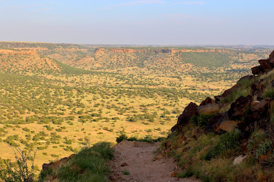
Rather abruptly, the trail cuts to the south and enters a canyon. There's a lot more flora in this canyon, with juniper bushes growing more densely, and the ground becomes notably rockier. This is the only part of the hike with significant elevation gain, as I rather steeply ascended the 700' to the summit plateau. The canyon section was in shade, which was appreciated, but the incline up the ridge itself was in full sun. Still I felt good, making sure to stop every fifteen minutes for a drink. The top of the ridge has an extensive overlook over the valley below, where I could see almost all the way back to the trailhead. |
| Flat-topped mesas characterize the landscape around the highpoint. |
.JPG) |
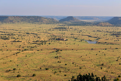
| Large rocks and small ponds dot the valley below while ranch trails cut geometric lines across it. |
 |
| Looking down at canyon-like features across the valley from the overlook atop the ridge. |
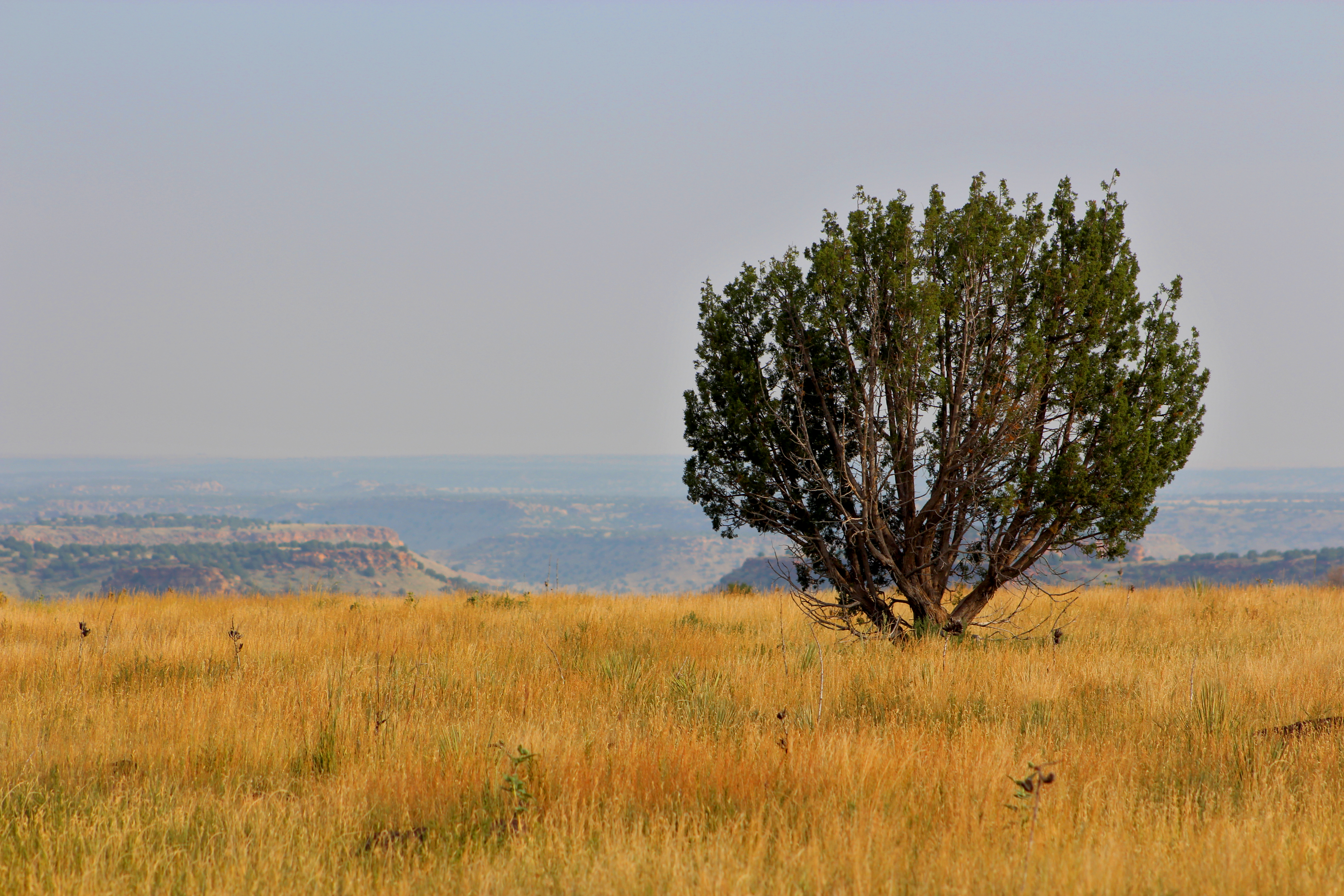
The top of the mesa was a totally different world. The land up here was perfectly flat, probably the flattest I had ever seen, and this was on a trip that included driving across both Kansas and Iowa. The grass was brown and the whole environment was very arid. Only a handful of bushes dared to endure the conditions up here. The only animal life I could see were great big beetles and crickets, the largest insects I had ever seen, that flew ahead of me in little swarms with each step. Every time I stopped for a break, I had to check my bag for scorpions before picking it back up, although I didn't see any..JPG) |
| Looking out across the flat, arid, and unforgiving mesa. |
 |
| One juniper bush dares to grow in the harsh terrain near the mesa's edge. |
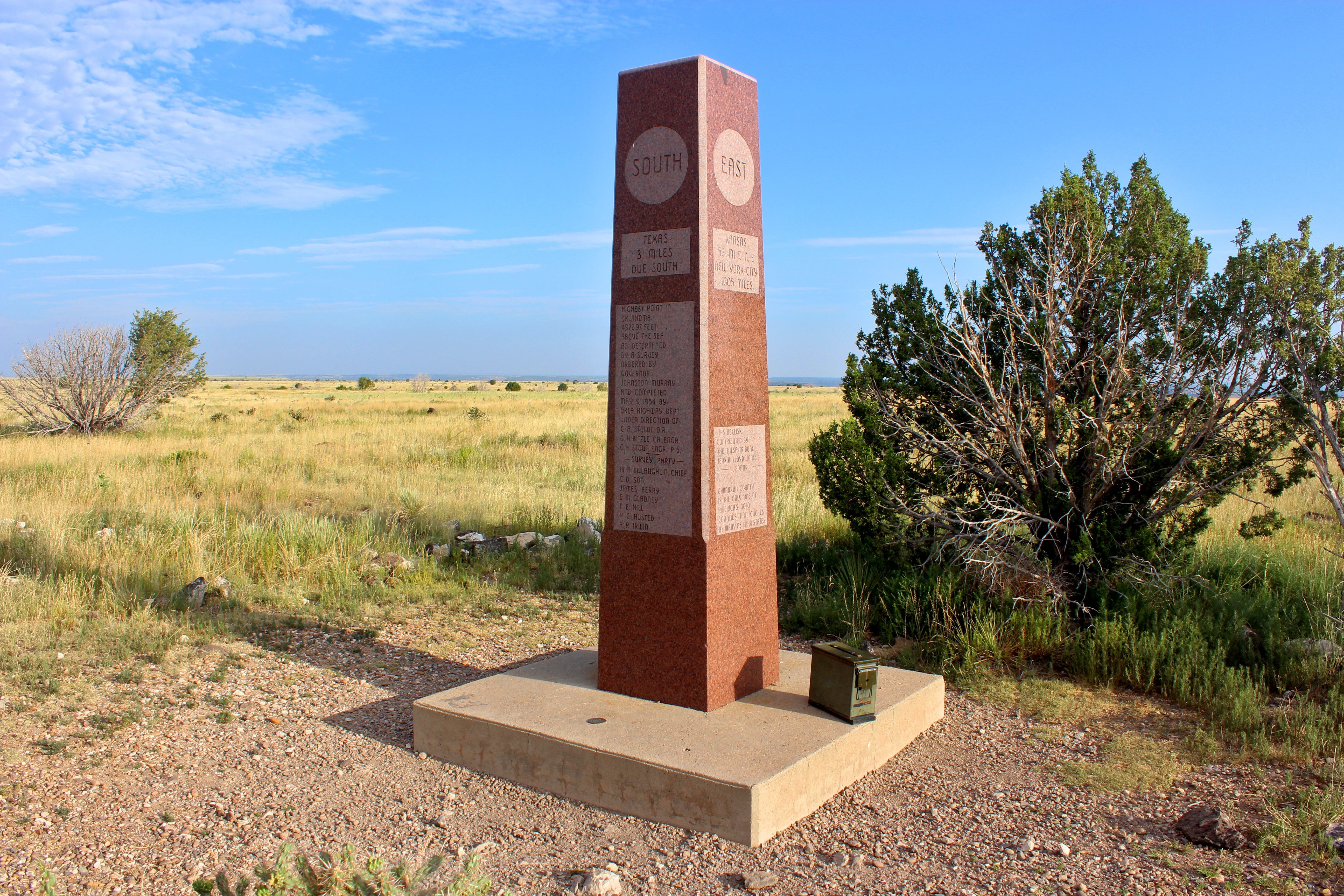
The bright side of the mesa's flatness was that I could see the summit marker from a pretty decent distance. The top of Oklahoma is marked by a ten-foot granite obelisk engraved with information about the peak. According to the marker, the highpoint is only a few hundred yards from the New Mexico border. I signed the summit register at its base and then hung out for a little while on some benches at the summit. While I was there, an older couple arrived; they explained that they were beginning a long trip and that Black Mesa was their first stop. |
| The summit marker. Note the register on the ground at its right. |
 |
| Somewhat unusually, the summit is marked not by the USGS but by the Oklahoma Highway Department. |
As the sun continued to rise, the lack of shade in the open summit became more and more noticeable, so after a few minutes, I began my descent. Descents usually seem to go a lot faster than ascents, but in this case, likely due to the increased temperature, everything seemed to go slower. This may also be partially due to the lack of elevation change; except for the canyon section, the hike is flat not matter which way you're going.
.JPG) |
| Looking out across the valley from the overlook at the edge of the mesa. The less-steep slopes are covered in 'forests' of juniper shrubs. |
 |
| One of several muddy pools in the valley used by grazing cattle. |
.JPG) |
| Looking down the trail in the canyon section of the descent. |
The bottom half of the descent seemed to go a little faster, mostly I think because I was tired and zoning out through most of it. The surrounding terrain was still incredible enough to catch my attention, and I remarkably never became dehydrated, but I was still finishing up a nine-mile hike, and that would be enough to tire most people out. At this point my main focus was not walking into any more cacti.
 |
| View of the mesa walls to the north from the bottom of the valley. |
.JPG) |
| Part of the canyon up which the trail climbs. This was definitely the greenest part of the hike. |
.JPG) |
| Following the trail on the way back out to the trailhead. |
Getting back to the car was a relief, and I quickly hopped back in and pinned the AC. I tried for awhile to figure out how much time I had left in the day, but Black Mesa is located right next to a time zone boundary, and my phone was all confused, which only served to confuse me. I ended up just driving out into New Mexico towards my next stop.
I had never been in New Mexico before, and typically I like to make at least one significant stop in each state when I'm visiting it for the first time. This time, I planned to visit Capulin Volcano, a national monument in the northeast part of the state. However, the road to the summit was closed, and I didn't have the time for another desert hike today, so I was forced to cancel this side-trip and simply begin my long drive lengthwise down the state.
.JPG) |
| Roadside sunflowers and distant mountains in New Mexico. |
I planned to sleep that night south of Carlsbad, and my GPS took me down very rural, dusty backroads for almost the entire length of the drive. Towns were nearly an hour apart, and only very rarely were they large enough to have restaurants or gas stations. I drove through several little dust storms on some of the long, windy straightaways. After several days in the midwest, the wonder of the plains had left. I was growing tired of long drives through the endless flat, brown, featureless landscape.
 |
| Thunderstorms receding over the desert south of Carlsbad. |
It was early evening when I finally made it to Carlsbad. Here I got food, gas, and supplies for tomorrow's climb, the crux of the trip. As I arrived, a rare desert thunderstorm was on its way out, making for incredible views along the drive, including a rainbow over the arid plain. Here I was also able to call Audrey and my parents and let them know that I was still alive after a day in the cell service-less wilderness.
Carlsbad is home to the famous Carlsbad Caverns, and unfortunately, there was no way for me to stop and visit, so I promised to do so the next time I was in the area. I left the city around sunset and headed farther south, crossing the Texas border for the first time as the towering Guadalupe Mountains came into view, ending an afternoon of flat desolation. I stopped to sleep at the Pine Springs Rest Area right near the border when it was just barely dark enough to do so. I set an alarm for early tomorrow morning to make sure I got to the final highpoint in time: Guadalupe Peak.

.JPG)


.JPG)

.JPG)

.JPG)

.JPG)

.JPG)

.JPG)
.JPG)
.JPG)

No comments:
Post a Comment