Orange County: NY County High Point 11/62
For much of this week, I've been working all the way down in New Paltz, which means a tiring 90-minute commute, and haven't had the energy to do much. However, after work let out early on Thursday, I took advantage of our southerly location to bag the Orange County highpoint. I figured the commute (and gas expenses) wouldn't be nearly so frustrating if I thought of them as part of the hike.
This was probably the most unprepared I've been for a hike in a very long time. I spent about five minutes looking up the county highpoint, how to get there, and the trail map, and headed out. Schunnemunk Mountain is the centerpiece of a state park by the same name, and being in a fairly populated area (most of Orange County is) the trail system is rather extensive and well-trodden, so I looked forward to an intellectually relaxing hike.
The mountain has two parallel ridges that run north to south, and the western ridge contains the true summit, so I chose a path that would wrap around the mountain from the eastern trailhead and ascend from the north, hiking the ridgeline to the highpoint. I guessed that this was around five miles round-trip and maybe a few hundred feet of elevation gain, so I didn't bring water or food to travel light. The actual numbers are 7.5 mi and 1790'.
A note about pictures: I'm still working to use the new camera and its cumbersome Canon-specific image formats. I tried converting these to more conventional formats, but free converters online all have limits to how many conversions you can do in a day. I used five different converters, and as such the coloration and contrast on these pictures varies wildly. Think of it as stylistic variety rather than technological incompetence.
The trail started out in a field, on the opposite side of the road from the mountain itself, and crossed over into the woods after about a thousand feet. Despite the open nature of fields, the only view afforded in this part of the hike was of the railroad trestle that crosses overhead, and the passenger trains that ride on it. Bulletins at the trailhead were very insistent that crossing the railroad, whether directly or under the bridge, was strictly forbidden.
 |
| The trestle bridge appearing over the crest of the open hill. |
 |
| A passenger train passes overhead on the Port Jervis Line. |
After a short section of switchbacks, I turned onto the red-blazed Otterkill Trail. This would bring me around the north part of the mountain, where I could start climbing towards to the ridge. However, this path was not without its elevation gains, and I soon found myself at a small east-facing overlook well above the train tracks.
 |
| A view of Beacon Mountain (L), on the other side of the Hudson River. |
Unfortunately the trail descended about a hundred feet from here, which is always disappointing to see on ascent. Soon I reached the junction with the yellow-blazed Jessup Trail, which would take me all the way to the summit. The junction is just after crossing the Baby Brook, and the trail runs along the brook for over half a mile, ascending some 700' in that time. It was surprisingly steep for a popular trail; I often underestimate the difficulty of shorter mountains, much to my own misfortune. The trail goes through a hollow carved by the brook between the two ridges, and I passed a number of waterfalls along the way.
 |
| Rapids on the Baby Brook just above the train tracks. |
 |
| A large (~20 ft) waterfall high up the trail, just below the ridge. |
 |
| The upper portion of the above falls, descending from just a small stream. |
After a fairly intense mile of constant ascension, I crested the ridgeline and found myself in a totally different world. The deciduous forests and mossy, leafy soil were suddenly replaced by exposed granite bedrock and barrens of shrub-like pitch pine and scrub oak. Extensive views to the north and east looked over the Catskills, the Hudson Valley, and hills in five states. A very strong wind served to cool me down as I stopped for pictures at the many clearings.
 |
| The limb of the west ridge extends over this north view into Ulster County. |
 |
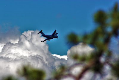
| A large transport plane on takeoff from the nearby Stewart Air National Guard base. Passing planes often sound like thunder, but the clear skies kept me from fearing any storms. |
 |
| A view of the west ridge, showing steep rocky outcrops like those to the west. |
 |
| Snake Hill (L) is a prominent feature from the mountain, breaking up the lowlands along the Hudson. |
 |
| The Newburgh-Beacon Bridge, on the of first bridges on the Hudson above New York City. |
By now I was at about 1500' elevation, less than two hundred feet down from the summit. However, due to the nature of the trail, I was less than halfway to the top distance-wise. The next mile and a half would consist of constant ups and downs, winding intermittently through sections of open rock and more densely forested areas. The trail was surprisingly difficult even up here; some scrambles and bouldering sections reminded me of the granite slides in the Adirondacks.
 |
| Looking east towards the stark terrain of the Hudson Highlands, dancing in and out of shadow. |
 |
| A housing development in Cornwall. The drive to the trailhead went through many upper-class communities, filled with houses even larger than these. |
 |
| Familiar Catskill peaks of Plateau (L), Sugarloaf (C) and Twin (R). Plateau looks unusually mountainous from this angle. |
 |
| The elusive, inaccessible Catskill High Peaks Graham and Doubletop rise over the level Shawangunk Ridge. |
 |
| A close view of open rocks and shrubs on the west ridge. |
After awhile, the views became gradually less common, and the trail became a more monotonous hike through pine trees and rocks. Occasionally, it would descend into deeper, denser forests more similar to those below the ridge, including a patch of mountain laurel that reminded me of hiking in west Florida. As I hadn't expected to go hiking today, I hadn't brought a change of shoes, and the rocky ground combined with my steel-toed workboots started to become annoying fairly quickly. Still, I pressed on, knowing that the sooner I got to the summit, the sooner I could return to the car for water.
 |
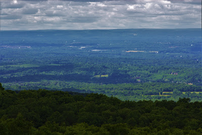
| Looking northwest over Orange and Sullivan counties, the land is remarkably featureless. I've never been hiking in Sullivan County, and this view reminded me why. |
 |
| A view of the Steward Air National Guard base in Newburgh. Adjacent to the sizeable Stewart Airport and a short drive from West Point, this base is often a hub of military activity. |
 |
| Storm King Mountain takes the center, surrounded by highlands on both sides of the river. This picture was converted differently than most of the others, resulting in different color and balance. |
 |
| A shrub-like pitch pine (Pinus rigida) bearing the yellow blaze of the Jessup Trail. Small pines and barren rock characterized the long ridgeline. |
Finally, unbeknownst to me, I arrived at the summit. In my extremely limited research, I used Google Maps to find the summit on the west ridge, inside of the 1660' elevation contour. However, as I studied the map along the hike, I discovered that there were in fact three 1660' elevation contours along the ridge, and there was no indication as to which one was the highest. Even the state park maps made no note of the summit, which I found strange for a park built around a mountain.
I ended up pulling up ArcGIS, Peakbagger, and USGS survey maps (thankfully I got cell service at the summit) to determine that the true summit was in the middle of the three contours, which happened to be where I was stopped. After searching to no avail for some sort of marker, I paused at the top to take some pictures before heading back down. The open sun made for good views (although there were not at the true summit), but also the risk of sunburn and dehydration.
 |
Schunnemunk Mountain, Orange County High Point, elevation 1664'.
With only the narrow-angle lens, I had to place the camera far away and scramble up a rock wall for the picture; doing so inside of ten seconds made for the grimace you see here. |
I've discovered a good way to determine the difference between thirst and dehydration: If someone offered you cold soda or lukewarm water, which would you pick? By descent, my answer was a strong 'water', and I was beginning to suspect that the hike may have been a bit longer than five miles. I wanted to get out of the rocky barrens and back into the shady forest below as soon as possible, but incredible views forced me to stop somewhat frequently.
 |
| Beacon Mountain is the large mastiff at left in this view of rocky hills across the river in Putnam County. |
 |
| Despite their impressive contours and steep rocky slopes, peaks in the Hudson Highlands lack the topographic prominence of the Catskills and Adirondacks, leading to the plateau-like skyline seen here. |
 |
| This hillside may seem wild and forested, but mansions dot its slopes, hidden among the green trees. |
 |
| Modern sculptures and open fields mark Storm King Art Park, an extensive outdoor exhibit of modern art located near the Hudson River. |
Soon I popped back down below the barrens and began descending the steep rocky trail alongside the Baby Brook. I seemed to be making good time, but my phone indicated otherwise, as the hike had already taken over two hours so far (it ended up taking just over three, bad for five miles but good for almost eight). I started marking landmarks to look out for on descent: The waterfall, the bridge over the river, the little overlook, the descending switchbacks, etcetera. The extra elevation gain on descent was annoying as I was severely dehydrated by then, but soon I reached the little overlook and knew it was all downhill from here.
 |
| The railroad bridge over the Baby Brook, seen from the wooden hikers' bridge. |
 |
| Storm King Mountain seen from the little overlook over some rural houses. |
 |
| Graffiti marks a decaying structure along the railroad, perhaps and old stop or control station. |
Soon I returned to the field, the car, and back home, still making it back before I would usually be home from work. With the hike, the long week at work dissolved away, and plans for more hikes in the weeks to come became more exciting,


No comments:
Post a Comment