Millbrook Ridge: Catskill Hundred Highest 42/100Woodpecker Ridge: Catskill Hundred Highest 43/100
In the continual quest for greater and longer hikes, I've long understood that overnight trips would one day become a necessity. Hikes of 16-20 miles are already pushing the envelope for a single-day trip, and as the mountains I'm looking towards climbing are getting farther and farther away. Therefore, I decided that I would begin doing overnight, solo camping hikes this summer. In preparation for more serious upcoming hikes, I decided to conduct a trial run close to home.
I selected three mountains in the southern Catskills, all in the Catskill Hundred Highest so I was working on one of my peakbagging lists. Millbrook Ridge is one of the highest non-High Peaks in the Catskills, and hiking it was briefly required for membership in the 3500 Club. The other two, Woodpecker Ridge and Cradle Rock Ridge, both required decent length bushwhacks from the main trail. Given its relative proximity to home, and the relative ease of the mountains, I figured this was an excellent choice for my first solo overnight hike.
My plan was to set out late Friday afternoon and hike up from the west side of the ridge, starting at Alder Lake. (An eastern approach would follow part of the hike I did up Balsam Lake Mountain back in 2019, and I wanted to see something new). I would hit Millbrook and the bushwhack to Woodpecker the first night, then double back to spend the night near the Beaver Meadow lean-to. Then, in the morning, I planned to bushwhack Cradle Rock Ridge before returning to the car, and from there back home (I had plans for the rest of Saturday).
I started off from the parking lot at Alder Lake a little before four in the afternoon. This was a bit later than I had anticipated; packing (and sleeping in) held me back, along with a last-ditch (unsuccessful) attempt to find a bear canister locally, or at least a rope to hang my food. Still, it's June; darkness doesn't typically set in until after eight, so I figured I would have enough time to complete the day's itinerary if I moved fast. I wasted no time, quickly hiking around Alder Lake and passing several large groups of campers at the lake's roadside campgrounds. These were the last people I would see until late Saturday morning.
 |
| The ruins of the Coykendall Lodge, a historic lakeside house, are located right at the parking area. |
 |
| Looking east over Alder Lake from the trailhead. While the mountains may seem short, the lake is already at 2186'. |
 |
| Cradle Rock Ridge, one of the trip's goals, over the dam at the end of the lake. |
 |
| Looking towards Millbrook Ridge over Alder Lake. |
 |
| The trail wrapping around the north side of the lake often afforded views through the swampy forest at its fringes. |
At the east edge of the lake, I followed the Millbrook Ridge Trail as it branches off - and up - towards the east. This trail is pretty level for the first two miles or so, gaining elevation steadily but slowly. It runs parallel to the Alder Creek, although as it gains elevation, the creek remains low at the bottom of a gulley; there are also some wide open, swampy areas along the side of the trail. I think most of these are beaver ponds; this area is crawling with beavers, with dams and dens all over the place.
Soon, I arrived at the Beaver Meadow lean-to. I planned to stay near this shelter; as shelters can be somewhat sketchy, and I wanted to test out my new tent, I would camp nearby, rather than sleeping in it. To my surprise, it was still empty, even this late in the afternoon, and as much as camping alone was a little scary the first time, I still hoped that I wouldn't need to share the area with anyone else. The lean-to overlooks a great big beaver pond surrounded by some wetlands and crowded with wildlife, and after checking out the surroundings a bit, I continued my march up Millbrook Ridge.
 |
| A beaver den in the aptly-named Beaver Meadow, with Cradle Rock Ridge in the background. |
 |
| The water at Beaver Meadow is held by the largest beaver dam I've ever seen, over two hundred feet across and easily ten feet deep. |
 |
A fairly steep trail behind the lean-to leads to a piped spring where I topped off my water supply.
|
The ascent up Millbrook Ridge was pretty steep but not terrible, with a good mix of easy scrambles, steep hiking, and even some switchbacks. I reached the top by five in the evening, making exceptionally good time on the climb. After a series of ridges (each one I hoped was the summit), the trail levels out by a large rock in a small clearing, near a swampy area. Assuming this to be the top, I took my pictures here and stopped for food and water. Right around the corner, I found a slightly higher point marked with a small cairn, the true summit, but it wasn't worth taking off my overnight pack and going through everything all over again.
 |
| Millbrook Ridge, 3480 ft. This picture is from the rock at the lower summit. |
 |
A cairn and a scraggly birch tree mark the true summit a few hundred feet away.
|
 |
| The path crosses between rock outcrops on the way to Woodpecker Ridge. |
I didn't linger long atop Millbrook Ridge, and soon headed over to my next stop, Woodpecker Ridge. Woodpecker Ridge has two summits, one to the north and one to the south. The trail goes right over the northern summit, with an overlook there looking southwest; unfortunately, the southern summit is the highest point, and that would be my goal for tonight. I knew the hike over would involve descending over three hundred feet, then immediately reascending nearly the same distance, but I hardly felt the elevation gain, and seemed to reach the Beecher Lake Overlook on the mountain's west side in no time.
 |
| Looking southwest from the Beecher Lake Overlook towards Mongaup Mountain. |
 |
| Walnut Hill, twenty miles away in Liberty, peers above the more impressive, nearer mountains in the evening haze. |
 |
| The grassy shores of Beecher Lake, home to a Buddhist temple hidden deep in the mountains. |
 |
| Located at the bottom end of the Catskills, most of the hills visible from Woodpecker Ridge are gradual and rolling rather than the steep slopes of the more northerly mountains. |
I didn't linger long at the overlook, as evening was rapidly progressing, and the next stage of the day's hike would be the most dangerous. A few hundred feet past the overlook, the trail reached the highest point on Woodpecker Ridge's shorter, north summit. It was a roughly half-mile bushwhack south along the ridgeline to the true summit. While planning this hike I noticed that the forests on Woodpecker Ridge appeared sparse on satellite imagery, which meant they were either open and easy to travel, or full of dense, low-growing brush.
Unfortunately, the latter turned out to be the case. I carried both poles in one hand and my machete in the other as I bushwhacked through dense beech forest the whole way to the true summit. I did my best to follow the ridgeline; even on descent, I stuck to the ground that seemed the highest, and used maps pre-downloaded on my phone to mark my progress. The thick leaves made determining my location by sight all but impossible.
The unrelenting ridge, reminiscent of a much longer version of Richmond Mountain, was broken occasionally by clearings filled with waist-height ferns, which made it impossible to tell what the actual ground looked like underneath; many concealed holes and boulders slowed my progress. Finally, I ran up a series of steep fern-covered slopes and arrived at the densely-forested summit, taking a few pictures before heading back to the trail via a slightly more direct route, breaking through the walls of beech trees back to the trail.
 |
| Woodpecker Ridge, 3460'. At the summit after a short but challenging bushwhack. |
 |
The fern-covered hill slope, the last of a series of three, before the summit.
|
 |
| One of the clearings full of ferns. |
It was beginning to get late now, and the descent felt like a little bit of a race, both against the sunset and against any other potential campers. On the way up I had identified possible campsites, including at the summit of Millbrook Ridge, in case I didn't make it back in time, but I moved quickly and soon reached the still-empty lean-to with plenty of time to spare.
 |
| Evening sunlight fills the trail on the westward descent. |
 |
| Beech trees along a steep section of trail below Millbrook's summit. |
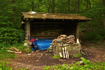
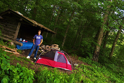
I wasted no time setting up camp, while simultaneously eating a simple, non-cooked dinner. I set up my one-man tent pretty easily, right on the 'front lawn' of the lean-to, and familiarized myself with my surroundings. The lean-to itself was somewhat sketchy, its inside covered in graffiti, bird poo, and trash, but there was a nice rope there to hang my food for the night. This was a relief to me, as I had no rope and no bear canister, and keeping my food safe from the bears had been a concern all day. I hung it along a tree near the lean-to and was pretty well settled in by eight o'clock, leaving almost an hour of daylight with nothing to do.
 |
| A view of the lean-to from the shore of the beaver pond. |
 |
| One of the two beavers I saw, swimming around in search of more wood for the ever-expanding dam. |
 |
| A view from the lean-to after setting up camp. While the sunset was a beautiful pink, the colors here are the result of poor camera contrast. |
 |
| Posing with the campsite after setting up. |
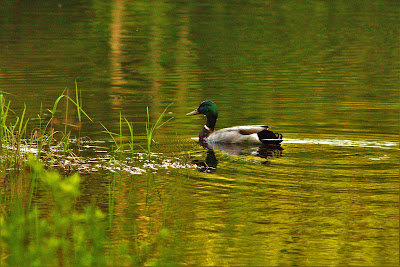
While I initially feared becoming bored, I discovered that the pond I was camped by was in fact quite captivating. Full of activity, I spent the next hour standing among the reeds on the shore of the pond watching nature at work. A mallard duck and his three ducklings swam around the pond, two beavers travelled to its shores to fell small trees, frogs peeped back and forth all around me, and a bird nesting in the lean-to flew around catching bugs. It was too early in the season for mosquitoes so there was nothing to bug me as I hung out in still silence. As the evening light waned, dozens of fish began leaping out of the water all around the pond to catch bugs.
Neither words nor pictures can capture the intangible serenity of the evening. Watching nature happen around me, the forest living out its life, the cast of characters performing in this little mountain pond. I realized that it wasn't about me, that none of the animals cared that I was there, they weren't out to get me or run away from me. All fear of spending the night along in dark, remote forest melted away. The words of Psalm 23:2 came to mind: "He maketh me to lie down in green pastures: He leadeth me beside the still waters." As I watched the moon rise over the pond I imagined never leaving this beautiful place.
 |
| A male mallard (Anas platyrhyncos) swam around the side of the pond whenever I would approach the shore, protecting his three ducklings. |
 |
| One of the ducklings, swimming obliviously by me. The beavers swimming under the water often spooked this duckling, making for some commotion. |
 |
| One of the large beavers (Castor canadensis) working on the den. Watching the beavers work made me wonder if they ever 'finish', or just build their whole lives. |
By around nine o'clock I finally went to bed, half due to darkness and half due to tomorrow's early rising plans. Here I learned a few lessons about camping, the goal of this shakedown trip. Firstly, covering the tent is important; my tent faced the pond, and the ceiling is totally open, which promised a great night under the stars. Instead, it mean the bright moon kept me up, and temperature in the low 40s gave me a runny nose the next morning. Secondly, bringing a mat is also important. After carrying around the heavy overnight pack all day, sleeping directly on the rock ground (including, notably, a rock directly below my head) didn't make for great rest.
Aside from the moon and the rocks, I was often woken by the beavers felling small trees into the pond; a moment of sleep would be interrupted by a crack and a loud splash. Snapping twigs around my tent would wake me occasionally, but didn't worry me too much. However, I didn't get much sleep, and what sleep I did get wasn't great.
In the morning I woke late (it was almost 6 AM!), and due to the low temperatures, it took over an hour to convince myself to leave my nice warm sleeping bag. By the time I left the tent it was well past sunrise, and the pond was nice and quiet. I took down my food from the tree, finding to my delight that the bears hadn't touched it, and as I set up I prepared to make a difficult decision: Do I hike Cradle Rock Ridge?
Cradle Rock Ridge, the third Catskill Hundred Highest of the hike, was a significant bushwhack, well over two miles round-trip, and after the difficulty of last night's bushwhack I wasn't sure I was prepared for that. After a night on the rocky ground my back felt fine - that is, until I put on my pack. I scoped out the area and found that the only easy way to Cradle Rock was to cross some steep gullies on the Alder Creek. With my normal pack this would be no problem, but with the late start, poor sleep, and larger, heavy pack, it didn't seem all that feasible. My mission was a success, I had packed in and survived the night, and at this point I really would rather have been home.
 |
| Mossy rocks in the Alder Creek on the way back out. |
I packed up and headed back down the trail, a bit disappointed that Cradle Rock Ridge didn't happen but mostly glad to have successfully camped for the night. I reached the lake pretty quickly, before most of the casual campers down there had woken up, and headed home quickly for the rest of the day's long itinerary.


No comments:
Post a Comment