Black Elk Peak, elevation 7244'. South Dakota highpoint, U.S. state highpoints 30/50. Solo ascent via Harney #9 Trail. 7.6 mi, 1598' gain, 2h43m RT.
It was the fourth day of my Great Midwest Roadtrip, a week-long solo excursion focused on bagging state highpoints. I had just returned from a morning in the Badlands, where I had done a number of short hikes and visited every overlook I could find over the course of the morning. My next stop would be the state's high point, Black Elk Peak, a much longer hike located deep in the Black Hills, about three hours west of the Badlands.
Most people would consider it a little bit crazy to try to hit the Badlands and the Black Hills on the same day. Many would plan vacations (including, at one time, myself) spending a week in the area to comprehensively hit both parks. I had worked out a plan that, I hoped, would allow me to spend a lot of time in both with only one day available in the region. I had completed three hikes in the Badlands that had a combined length of about five miles, and the climb up Black Elk would be nearly eight. I was a little concerned about how well I'd put up with thirteen miles of hiking in total sunlight in the ninety-degree weather, but I was confident that a highpoint would provide enough motivation to push through.
Driving in through the Black Hills was astounding. The forests consisted exclusively of pine trees and conifers, with open, grassy ground beneath. The 'hills' were comprised of great towering rock formations, all silvery and white in stark contrast to the forests that capped them, with impressively steep slopes. I drove past all the signs for Mount Rushmore (a peak that I would probably appreciate more if they had left it alone) and through something called "the Needle", where the road travels through a narrow, single-lane hole in the rock.
After an hour's drive on twisty, steep mountain roads, I finally made it to Custer State Park. I paid the entrance fee and found a parking spot at Sylvan Lake, the most commonly-used south trailhead for the peak. The lake was absolutely crowded, something that wasn't surprising on such a nice (if a little hot) summer day, and crowds of visitors were swimming in the lake. Finding a parking spot was no easy task, and I ended up parking some distance from the trailhead. I loaded up my pack, prepared for a long and steep climb in very hot conditions, and headed out. It was about three in the afternoon when I left the car.
 |
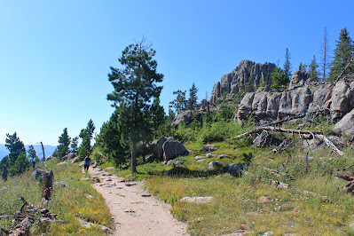
| A view of rocky outcrops from a grassy meadow early on the trail. |
The trail started out pretty level but started climbing pretty quick. I had never hiked through an environment like this before, where the 'forest' is very open allowing for fairly expansive views all the way up. It was tempting to stop every few feet and take a picture, but I knew I was already starting pretty late and needed to move fairly quickly. I turned right at a junction to stay on the trail and soon found myself at the top of an outcrop with views towards my afternoon goal. |
| A view from the overlook about a mile and half into the climb. |
.JPG) |
| A view down the wide trail. |
From here, the trail descends to a low col with a creek crossing. The forest here is much denser and the environment was more humid; presumably the denser trees hang on to humidity from the creek. This area goes beneath a rock formation named Little Devil's Tower, a massive rock spire visible in the sky through the treetops and too big to fit in a frame.After this low area, the trail steepens out again and begins rapidly accumulating elevation. This area is where all south-approach trails converge, so the mountain was somewhat crowded, although most groups I encountered were descending. The environment up here was a lot more open, with many off-trail blowdowns likely due to high elevation winds. Wild raspberries were just in season right off the trail, and after I saw other hikers eating them (thus proving they were edible), I stopped to enjoy some natural refreshment as I neared the summit.
.JPG) |
| The elevation became more evident as the forest became more sparse. |
 |
| The trail and environment at elevation. Note the comparative paucity of trees here. |
As I approached the summit, I reached an elevation that was higher than I had ever been. My previous record, Mount Mitchell, topped out at 6684', nearly 600' shorter than Black Elk Peak. These are elevations that are typically too low to seriously worry about altitude, but with my asthma, I'm always on the lookout for how high I have to get to really start feeling it. Thankfully, whatever my limiting elevation is, it's far higher than Black Elk, since I didn't have any difficulty climbing up here.The trail became suddenly very steep as it approached the summit, also somewhat suddenly. An old staircase carried me up a steep section through a gap in the rocks, providing some shade from the hot summer day. It twisted around the summit block and suddenly, I found myself on the summit of South Dakota.
 |
| Looking west from the summit area over the lower hills. |
.JPG) |
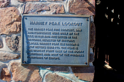
| Information plaque on the summit tower, using the peak's old name. |
 |
| Looking west over the forest where the trail runs through. |
The summit of Black Elk Peak is topped with a lookout tower, built in the 1930s by the CCC and used until relatively recently to watch for fires in the Black Hills. The tower remains as an observation deck, but a wasp nest in its ceiling led me to conclude that outside views were probably better. The tower and surrounding areas were built of brick, and a small dam held in a pond in the rocks beneath which was currently nearly dry.
 |
| Rock outcrops extend east of the summit. |
.JPG) |
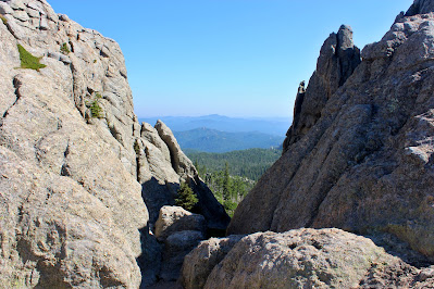
| A view through the rocks near the head of the dam. |
The summit wasn't too crowded, but there were a handful of people lingering there late in the day. I left the summit after a few minutes and headed over to McGillicuddy Peak, a sub-peak to the west that was nearly level with the summit itself. This peak contained the highpoint's USGS survey marker and was covered in prayer flags, emphasizing the mountain's importance to the Lakota Sioux.
 |
| A view of the rocky summit and tower from McGillicuddy Peak. |
 |
| The USGS survey marker at the summit. |
 |
| Blocks of stone, including one square-like formation, to the north of the summit. |
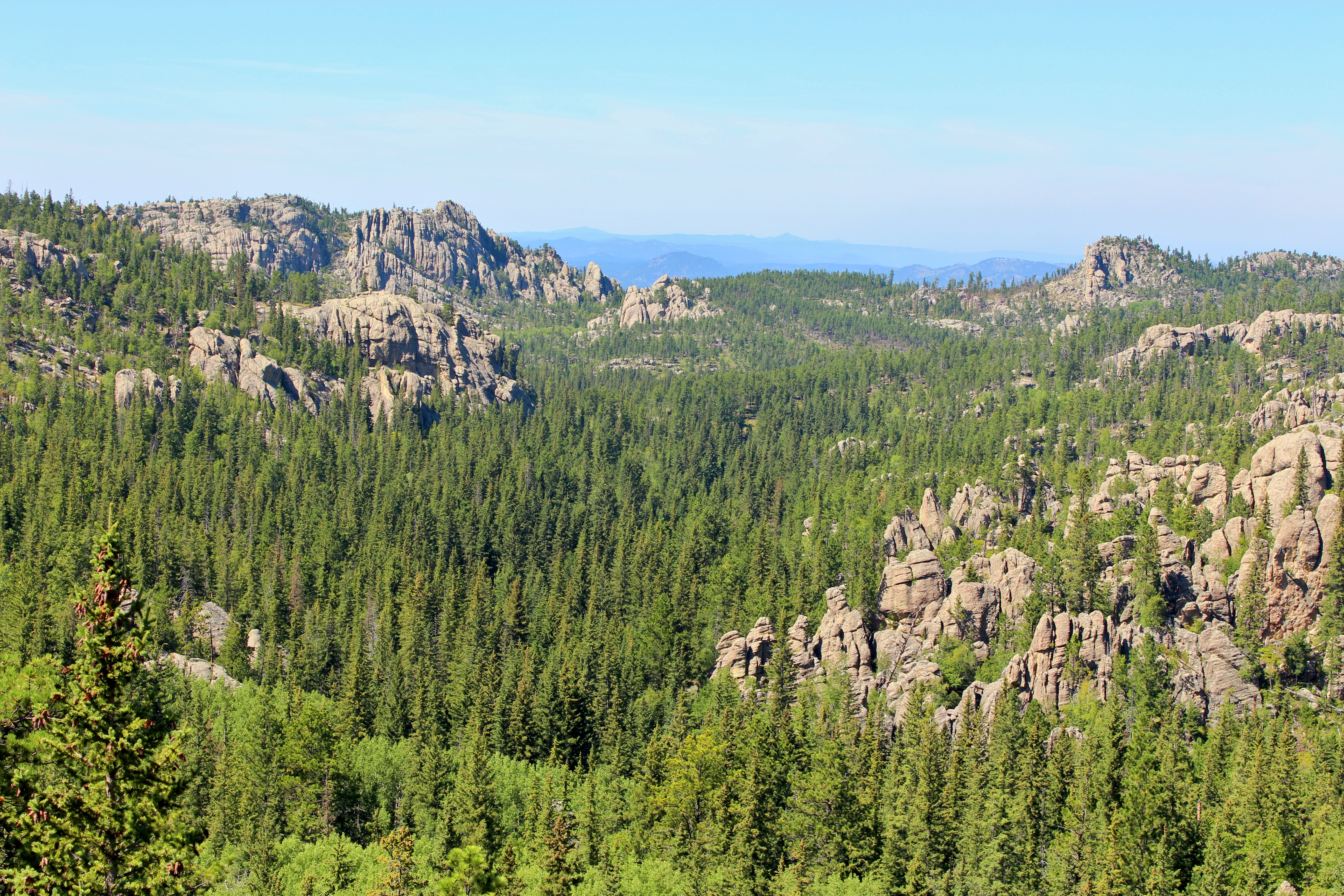
It was here at the more natural and deserted McGillicuddy Peak that I really stopped to appreciate the view. It was cooler and breezier up here at elevation, so the open sun didn't disturb me too much. The Black Hills are truly an incredible and unique environment, forests like those in the Rockies between unusual bare rock formations right in the middle of the High Plains. Furthermore, they're extensive enough that from here, in their center, all I could see in any direction was black forest and towering rock. I stayed here for a long time, probably close to half an hour, admiring and appreciating a stunning view on a perfect day.
 |
| A view of The Needles, a rock formation that I passed along the trail. These spires are popular with rock climbers. |
 |
| Looking down into one of the countless valleys below. |
 |
| Towards the west, late afternoon haze was already clouding the sky. |
After sufficiently appreciating the view, I headed back over the true summit and to the trail. The only person left at the summit now was a man about my age, hiking alone and enjoying the view and the silence much like I had been. Descent went quickly yet not quite quickly enough. As I descended back into the cool, forested valley, I passed a women with some young children on her way up. She asked me how far it was and I told her that she was unfortunately only halfway there, but she continued, despite the late hour. I then climbed back up a bit in elevation to the rocky overlook I had passed on the way up earlier in the afternoon.
 |
| Looking back towards the summit, with the tower at right and McGillicuddy Peak at left. |
 |
| The hills in the west seemed much larger from down here than they had on the summit. |
By the time I returned to the car, it was already evening. The lake had pretty much emptied out, I was exhausted and sunburned, and the Mr. Goodbar I had left in my car as a post-hike reward had turned to liquid. I enjoyed the trip out of the Black Hills and found my way back to Rapid City, where my tired and hungry self quickly became lost.
Rapid City is not a place you want to get lost. The area I ended up in was rather sketchy, and it made me sad to see problems with poverty and homelessness in an area that gets deathly cold in the winter. However, there was also a sense of community here that's usually lacking in urban areas. In any case, the long line at Wendy's gave me a lot of time to observe surroundings to which I was not accustomed.
The drive out of the Black Hills was fantastic. I got to watch the sunset as I sped out from the forests to the plains, giving me inspiration for a story that I planned to set in the region. I talked to Audrey all through the evening, and she listened in as my plans to camp that night in Nebraska National Forest fell apart and I became lost yet again in this distant land. Finally, I resolved to just drive to the nearest highway rest area, which unfortunately was in Wyoming. This meant skipping a planned stop in Scottsbluff and driving across the entirety of Nebraska in the darkness, never even seeing the state on my first visit.
More hungry than disappointed, I pulled into the Wyoming Welcome Center sometime around midnight and went promptly to sleep. I had more highpoints to visit tomorrow and I needed all the rest I could get.


.JPG)
.JPG)


.JPG)


.JPG)


No comments:
Post a Comment