It was the fourth day of my week-long midwest roadtrip. I woke up at a hotel in Mitchell, South Dakota, just recovering from a day that saw the conquest of three new state highpoints (Michigan, Wisconsin, and Iowa) and ready for another day of adventure. I re-packed my belongings, raided the continental breakfast, and soon found myself flying westward on I-90.
The Badlands are a destination that I had looked forward to since long before I knew what a highpoint was. Back in 2017, I would spend hours (often at work) looking at photographs and panoramas of the area, dreaming of one day reaching it and wondering what it would look like in person. I had even planned a solo trip out there, but I was working full-time and hadn't sone much travelling yet, so it never happened. While this trip west was focused on highpoints, I knew I would be driving through the Badlands, and it was imperative that I stopped there.
I gave myself the first half of the day to spend in the Badlands, and I left the hotel early to maximize my time. The plains of South Dakota, as I discovered in my three-hour drive across the state, aren't nearly as flat as I had expected. In many spots, they roll in great, wide hills, and each river has a small canyon surrounding it, but the landscape is always barren.
One of the most interesting parts of the drive was the billboards. The closer I got to the touristy part of the state, the more incredible and frequent the billboards became. Many played on the natural beauty or history of the state. One of the most enticing was a series of billboards for a place called "Wall Drug", which left some uncertainty as to what exactly the place was, but started hundreds of miles away. Unfortunately, my schedule wouldn't allow me to stop and investigate further.
I did have time to stop at a gift shop just outside the park, where I picked up souvenirs for family. I'm often travelling to all sorts of places but I rarely stop for memorabilia, generally considering it a waste of valuable time and money, but I figured it was worthwhile here, a place I had dreamt of reaching for over six years.
I paid the $50 entry fee, checked out the map and visitor packet I was given at the front gate, and pulled into a crowded east-facing overlook, the first I saw. As soon as I stepped out of the car, I recognized that my normal approach to natural attractions would have to be scrapped. If I stopped at everything that looked pretty, I would never leave, and if I took a picture of every beautiful scene, I'd run out of room on my camera.
 |
| Striped ridges rise out of green plains at the edge of the Badlands. |
 |
| Twisted segments of rock give the impression of a mountain with a knife-edge ridge. |
 |
| To the east, intermittent foothills rise out of the plains. |
 |
| To the south, the landscape is dominated by a seemingly endless sea of barren, lifeless, and beautiful rock. |
The whole overlook was silent, as though the whole crowd there was as stunned as I was at the beauty. In the course of my travels, I see a lot of unique and beautiful places, but few have stopped me in my tracks as much as the Badlands. I wanted to stay at this overlook all day, to analyze and appreciate every single rise and rill in sight. But I was on a time crunch, and it was already pushing 90 degrees, so I reluctantly returned to the car to continue my journey through the park.I had in my head a tentative plan of three prospective hikes in the park. All were relatively short and well-trafficked, and each was in a different part of the park, designed to give me a one-morning overview of the whole region. My next stop, the Door Trail, extended out into the rocky floor of one of the flatter areas of the park.
.JPG) |
| View of the towering, expansive terrain from near the trailhead. |
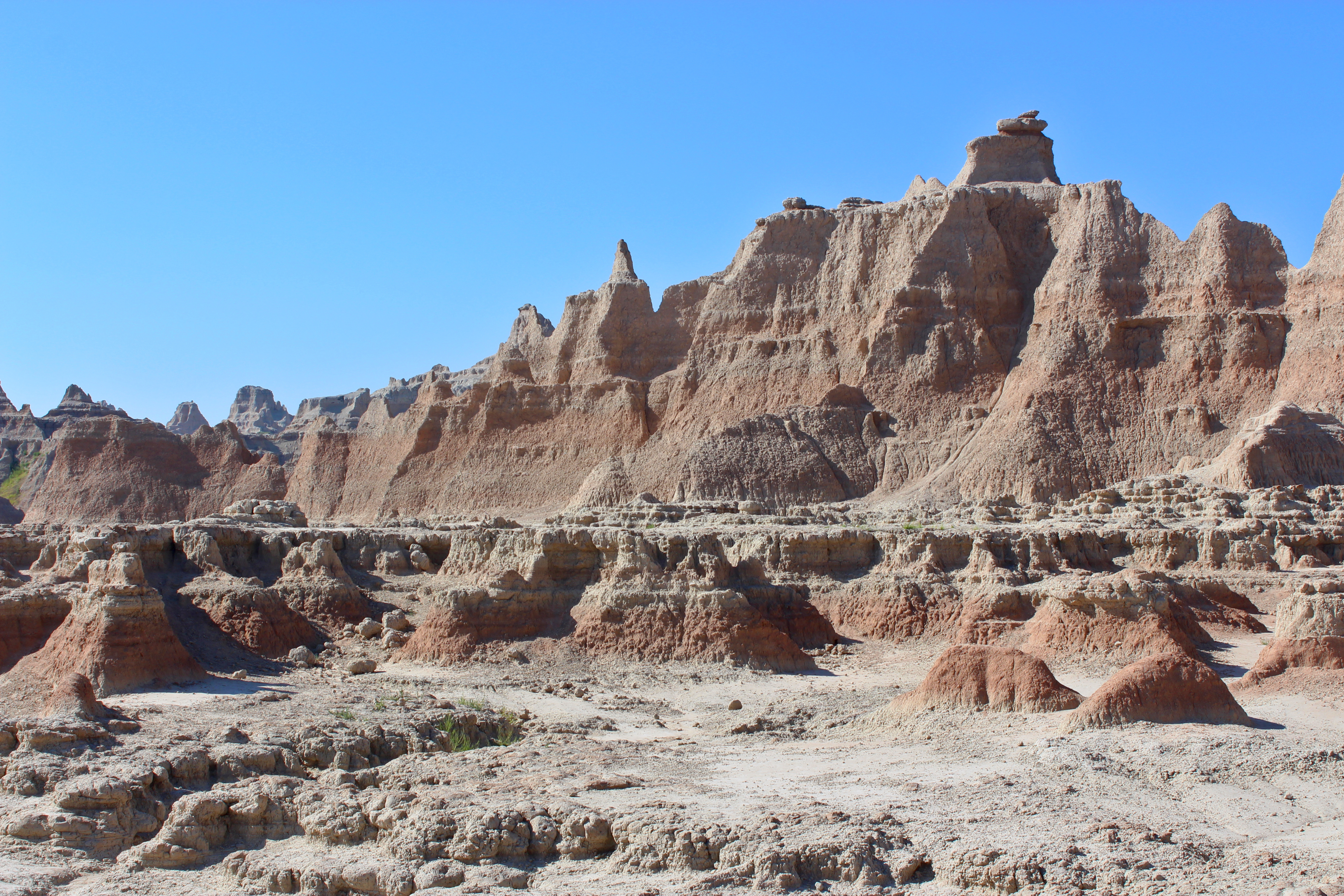
This trail was the shortest of the three, less than a mile round-trip. It wound around a wall of towering sandy stone, depositing me on a jagged and desolate plain. Towering mountains of windswept rock formations surrounded the area. The ground was composed of crumbly rock, often forming little balls that crumbled underfoot, and small, deep canyons cut through the irregular surface. Aside from a handful of yellowing bushes hiding in cracks in the rock, there was no sign of life anywhere.My first thought was that the area looked like one of those styrofoam alien planets from the old Star Trek. My second thought was how imposing this rugged terrain must have seemed to travelers and pioneers generations ago. No horse or wagon could make travel over this, there was no water in sight, and on a summer day like this, the heat was already oppressive even in the morning. While experienced locals knew to keep away, more ignorant European settlers could easily find themselves in a deadly situation in a place like this.
 |
| Towering rock formations give the impressions of some faraway desert planet. |
 |
| One of the deep-cut channels, with small bushes and grasses as the only life around. |
 |
| Rugged terrain, looking back towards the trailhead. Note the car for scale, near the base of the rock wall. |
Although no Gorn popped out of the rocks to do battle, I enjoyed the desolate scenery, and after a few minutes at the end of the trail, I headed back to the car. The trailhead for my next hike, named the Notch Trail, was located in the same parking lot as this one, but far on its other side. Out of laziness, and a desire to get back into the air conditioning for a few short minutes, I drove over to the other side of the parking lot, sat around just long enough to cool off, before starting my next hike.The Notch Trail was somewhat longer than the Door, about a mile and a half round-trip. I began hiking along more level ground, similar to the previous trail, but soon wound through a wide canyon with more greenery than I had seen in an hour. The trail climbs up the side of the canyon, officially via a rope ladder, although I decided to scramble because it looked more fun. I was impressed by the level of terrain that the trail climbed, some of which I'd consider Class 2, yet the trail was crowded with tourists, children, and inexperienced climbers. I understood the importance of the warning signs posted along the trail, warning of danger and the necessity of proper footwear.
.JPG) |
| Hiking through the canyon towards the Notch. |
 |
| Looking down into the canyon from above. Note the rope ladder at left. |
I found the rock formations here, especially while climbing the upper portion of trail along the canyon, to be rather difficult to keep traction on. The white stone is dry and cracked, and crumbles under the slightest pressure, turning into unstable scree. I had to adjust the way I walk, specifically on steep slopes, as the maximum grade I could safely walk on this terrain was much lower than I was used to.
 |
| The upper portion of the canyon, totally devoid of life. |
The trail winds through another, upper canyon, this one resembling a higher-budget alien planet out of Star Wars. At the end of this canyon is a great overlook, presumably "The Notch". This spot was crowded with tourists who had endured the crumbly hike out here, all enjoying the mid-morning view of the lower, less foreboding landscape beyond. There's a steep drop-off below the overlook, preventing the trail from continuing down, and the canyon walls on the inside of the overlook are similarly steep. Naturally, I scrambled up some of these walls as far as I felt was safe, obtaining a higher and somewhat more isolated view. |
| View towards the town of Interior, beyond the Badlands, through the Notch. |
 |
| Looking southeast from the wall of the Notch. |
I hung out here for awhile, due largely to both the view and the shade that the canyon wall provided, but plans for later in the day, combined with an accumulating crowd, led me to head back towards the car. On the descent, the area by the rope bridge was congested with ascending groups, so I and some other visitors decided to scramble down. This was considerably more dangerous than scrambling up had been, with each hand and foothold threatening to crumble under pressure. |
| The high canyon floor obscures the horizon. |
.JPG) |
| Looking down on the canyon on the way out. |
Descent went fairly smoothly from here, and once I was back in the car, I got a few more minutes in the cool air than I had before. It was a very hot day, and the barren landscape meant there was a near-total lack of shade on these short hikes I was taking. While the air was dry enough that the 90 degrees here felt more like 80 back home, it was still every bit as dehydrating.My next, and final, hike in the Badlands would also be my steepest. This hike, less than a mile round-trip, involved climbing the Saddle Pass Trail all the way to the crest of the pass. The steepest part of this trail, which was by far more wilderness-feeling than the others (no rope ladders, boardwalks, etc), involved a sustained grade of around 30%. This trail was also significantly less crowded than the others.
 |
| Looking up towards Saddle Pass from the trailhead. |
.JPG) |
| One of many rock outcrops along the trail. |
.JPG) |
| Looking out at badlands along Route 240, the main road in the park. |
The trail initially winds through mini-canyons, climbing through and over deep ridges in the rock formations at a constant uphill grind. This trail, though steep, was pretty straightforward, and I took a lot of shortcuts and side-trips, running off-trail to reach spots that looked interesting. Soon I reached the pass, a very flat, barren area high above the trailhead but level with the plains to the north.
 |
| A view of the flatlands at the pass. The promontory at right is West Saddle Peak. |
.JPG) |
| Looking out into the flatter plains level with the pass. |
After a moment at the pass - initially my destination - I identified a small peak to my west, which I would later learn is called West Saddle Peak. As the highest spot in sight, I naturally wanted to reach its summit, and soon scrambled up to the top. An unofficial, less commonly used path leads right up to the top, and along the ridgeline it's somewhat narrow. The summit had what seemed like a little notch just big enough to rest in, from where I took some pictures of the landscape.
 |
| Looking east from the summit into the late morning haze. |
 |
| Looking down on Route 240 where it winds around the rocks. |
The descent from here was significantly trickier than the ascent had been. I noticed as soon as I descended West Saddle Peak that the crumbly, cracked rock under my feet was very difficult to safely downclimb. As I continued my descent into the pass, I nearly fell several times, as it often felt like trying to walk on marbles. There was one gully-like segment of trail that I went down on my hands. Soon, however, I was back at the car, covered in red dust and thoroughly exasperated.
.JPG) |
| Rock formations in the pass on descent. |
I spent about another hour in the Badlands, driving westward on Route 240 and stopping at every overlook I could find. There was one spot where the road descended dramatically, winding through the towering ridges and bluffs, which was quite incredible to witness. At another point, there was an overlook at an area that included bright yellow bands in the rocks. I wanted to stay all day, but I knew I had more on my schedule today, and eventually I started getting a little tired of getting in and out of the car every few minutes.
.JPG) |
| Rugged canyons characterized by sharp terrain in a less windward part of the park. |
.JPG) |
| From another area, very rounded rock formations contain bright yellow coloring near their base. |
I bade the park goodbye, having finally fulfilled a six-year dream of reaching some of the country's most incredible terrain. It was afternoon by now, so I stopped in a nearby town for lunch and continued pressing west, my goals set on yet another extensive afternoon excursion: the Black Hills.
.JPG)


.JPG)


.JPG)


.JPG)

.JPG)
.JPG)

.JPG)


.JPG)
.JPG)
.JPG)
No comments:
Post a Comment