On the final day of my fleetingly short Easter break, I headed out to southern Mississippi to hike a six-mile portion of the Tuxachanie Trail in DeSoto National Forest. Mississippi is a state I had only been in once before, and only left the car to stop for gas, so it didn't really count as a 'visit' in my book. While poor weather had prevented me from visiting the state highpoint, I was still determined to visit a new state this weekend, even if I couldn't reach its top just yet.
Trying to find good hiking spots along the Gulf Coast is difficult; the coastline is all beaches, most of the inland forests are swampy and privately-owned, and it's a five-hour drive minimum to anything even resembling mountains. This generally worked out, since money and time are both in short supply on campus, but on the rare occasions where I had opportunity to go exploring, it was difficult to find somewhere to explore.
After awhile of searching I identified the Tuxachanie Trail as a nice hiking area. It was only a two-hour drive from campus, located in southern MS where the weather was much nicer (~70 F, sunny, and even low humidity), and included a swamp, multiple river crossings, and a lake. To make things even better, the hike would be twelve miles round-trip, a good way to keep in shape in preparation for the return home at the end of the semester. I headed out around noon and got on the trail in early afternoon, making sure to pack plenty of water this time (unlike my hike two days earlier) and some limited food supplies.
Despite my phone getting me lost somewhere in Mobile, I was soon in Mississippi, and headed out on the trail to enjoy hiking in a new state (the twentieth I've hiked in). The first mile or so of the trail went through open longleaf pine forests, then descended into a slight valley, with lots of shade and swollen rivers. There were some signs along the trail detailing the antebellum history of the area, and a number of other visitors there. I stopped at a small lake that was relatively near the trailhead and some of the muddy rivers farther on.
 |
| Forests along the edge of the little pond. Dotted with lilypads and reeds, this body of water was just skirting the edges of being a swamp. |
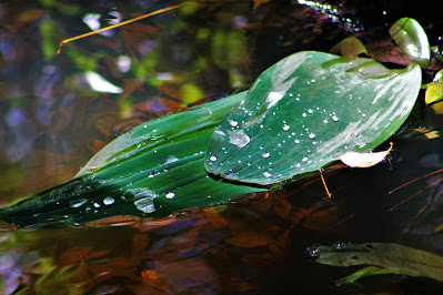 |
| Wide plant leaves held large balls of water out of the river, sparkling in the afternoon sun. |
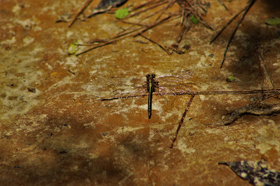 |
| A common sanddragon (Progomphus obscurus) rest on the sand ground along the trail. |
 |
| Recent rains (which kept me from hiking earlier) had swollen the West Creek, seen here at an old collapsed footbridge. |
Suddenly, the trail rounded a corner and the lush, green forest disappeared. Unbeknownst to me at the time, the forest here had been subjected to a controlled burn just three days before my hike. The rain over the intervening period had (mostly) extinguished the flames, but the trail looked like a post-apocalyptic wasteland. Wildfires are a natural part of pine savannas, and controlled burns are conducted regularly to ensure that the ecosystem continues functioning as God intended. And I was lucky enough to come in the immediate aftermath.
The next two miles of trail were almost completely burned. Tall trees stood firm, their lower trunks blackened with ash, while all underbrush had been reduced to cold coals. The gently rolling hills on either side of the trail were scorched and barren, and the still-smoky air smelled of burnt turpentine (which was harvested there a century ago). It was totally unlike any environment I had ever been in, and it was difficult to maintain a good pace as I just wanted to look at - and photograph - everything. Very occasionally, I would pass other hikers, like survivors passing by after some cataclysmic event.
 |
| A pinecone of the endangered longleaf pine (Pinus palustris), charred by fire. The seeds inside, however, are perfectly viable, designed to resist damage by flame and heat. |
 |
| The trail winds up a slight hill through singed trees and underbrush, at the edge of the controlled burn. |
 |
| When the forest burns, so does everything in it. This aluminum can, half buried, avoided melting or burning, while other cans in the vicinity were not so lucky. |
 |
| All that remains of two young palmetto branches after the burn. The palm itself will probably die, as these leaves are usually feet across; these remnants measure hardly an inch. |
 |
| A view of the burned forest. Badly burned, moisture-rich palm saplings are all the remain of the underbrush, while the ashen trees stand strong. |
At roughly halfway between the trailhead and the lake, my distant destination, the forest retuned to life, and I was suddenly surrounded by lush greenery and abundant animal life as well. I stopped for a drink at a little swamp, and found it filled with turtles. One of the larger turtles had part of its shell peeling off, and it didn't flee like the others when I approached the swamp's edge. I thought it might be dead, but it was gone by the time I made my return trip. Shortly afterwards I came across two turkey vultures, evidently feasting on something (I could smell whatever it was, but didn't go looking for it). They flew away as I approached and continued on the trail.
 |
| A flowering shortleaf sneezeweed (Helenium brevifolium) near the edge of the swamp. Part of the sunflower family, sneezeweeds often grow in swampy areas in the southeast. |
 |
| A wide view of the swamp itself, populated by standing trees and at least three turtles. |
 |
| The larger, flaky turtle that didn't seem to be afraid of me at all. This is definitely some type of map turtle, but my photos lack the detail necessary to positively identify which species. |
 |
| One of the turkey vultures flying away. I got many closer pictures of both of them gloriously in flight, but they were all out of focus. |
After leaving the swamp, the trail passed a few dirt roads and 4x4 trails until transitioning back into wide open pine savanna. This last mile and a half or so had been burned several years ago, and an extensive understory of brush and young trees had sprouted up since then. As I came out at a road crossing towards the end of the trail, I found the path blocked by a pink ribbon tied between two small trees. On the outside (road-facing) side of the ribbon was written "Trail closed for controlled burn 4/23". At first I was concerned that this trail was technically closed, but I surmised that the rangers had simply forgotten to remove this ribbon, since the other side of the trail was open and dotted with other hikers. I carefully jumped over and headed across the road.
 |
| Peering through the overgrown pine forest reveals evidence of past burns such as this charred standing trunk. |
 |
| Looking up City Road, the first paved road that the trail crosses, near the access point for Airey Lake. |
Finally, I arrived at my goal: Airey Lake. Airey Lake is a fairly popular location for fishing, and is most easily (and most frequently) accessed via a parking lot on the side of City Road. When I arrived, there were several people and a family fishing, and I felt somewhat odd stumbling out of the woods, taking a few pictures, and disappearing again. I didn't spend much time by the lake, but I was able to watch the fish swimming in the murky waters just off the shore. After a quick drink, I swapped out my lenses and headed back, prepared for the six-mile hike back to the car.
 |
| A bird feeder hides among reeds at the far (east) side of the lake. |
 |
| Thousands of tiny lilypads lined the soggy shorelines, with dozens of small fish swimming in their submersed shade. |
 |
| Countless tiny fish filled the lake, likely food for larger, bottom-dwelling animals; only three made it into this picture. |
 |
| A wide shot from the west shore of Airey Lake, showing plant growth and the pine forest on the far side. |
Back across the paved road, I headed back through the open, bright green pine savanna, this time with more speed. I had made very good time to the lake, covering six miles in around ninety minutes, and hoped to maintain the same pace on the return. As I was becoming more tired, that would require a conscious sense of urgency. The open pine plains were filled with smoke now, and part of me was concerned that the controlled burn was still going on in a nearby portion of the forest. This only accelerated my desire to get back to the car quickly, or at least back to the wetter portions of the trail.
 |
| Long afternoon shadows cast by the lanky longleaf pines across the trail. |
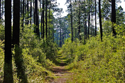 |
| Smoke is visible adding haze to the atmosphere in this picture looking down the relatively straight path. |
Some sections of pine savanna here were separated by a small section of dense southern forest surrounding the Saucier Creek, which gives its name to the nearby town of Saucier. The creek, like all the other rivers in the area, was muddy and swollen, and the only way across was a decrepit old wooden bridge. At some point, a flood had lifted the bridge off its foundation and lodged it diagonally across the river, with its one end up in the air and the other nearly touching the water. It didn't quite look safe, but with no other way across the creek, I walked across, finding it remarkably stable in spite of its appearance.
 |
| A view of the tilted bridge from the east side of the creek, showing the dense, overgrown forest. I was happily surprised that it handled me crossing it twice. |
After this I headed into another long segment of open pinelands, this one considerably less smoky than the previous one, along Martha Redmond Road, a dirt road that cuts through the park. This was the last major section of unburned pine forest, and I pushed through it quickly, keeping track of my progress in a race against time for fun. I never saw any other hikers in this portion of the trail, and was still somewhat worried that it was technically closed, but there were no cars on the road, so once I was across my limited fears of getting in trouble rescinded.
 |
| Walking southwest on the return trip took me straight into sunlight, making for good views and difficult pictures. |
 |
| One of my last shots of living pine savanna in a very clear area near the crossing. |
 |
| Afternoon shadows cross this south-facing view of Martha Redmond Road. |
On the west side of the road, the forest returned to intermittent living and burned-out sections. Here I was startled to find some large pine logs still smoldering on the side of the trail. It was strange that they would open the trail while there was still fire burning, but at least that explained the smoke I had seen earlier. This trail had mile markers along its whole length, wooden markers along the path every mile, which allowed me to keep track of my speed; somehow, these weren't effected by the fire, so I made sure to keep an eye out for them as I raced myself back to the car.
 |
| Smoke rising from a fallen pine tree just off the trail. I had to do a double take and make sure I was actually seeing this, as it was very unexpected. |
 |
| A transition area near the edges of the controlled burn, where the dead ashen wasteland abruptly turns into live green forest. |
 |
| A young longleaf pine seedling in what's known as the "grass stage" seems to have survived the fire (note the green left in the needles), a testament to the tree's incredible durability. |
 |
| The wooden post at mile marker three, the halfway point of the trail. The ground around it is all black and burned, but somehow this post survived unscathed. |
After crossing another small dirt road, this one an unnamed forest maintenance road, I returned to the nearly two consecutive miles of burned savanna. I approached this with a new light knowing just how recent the burn had been; suddenly the intense smell of burned wood and wasteland-like appearance of the forest made a lot more sense. It was difficult to imagine that the environment would soon recover from the fire, but I had seen other recovered areas and knew that in a few years' time, this two-mile tract would be as lush and green as it presumably had been a few days prior.
 |
| More long shadows cross the dirt access road, just under three miles from the trailhead. |
 |
| Heavy rains following the burn made for an odd juxtaposition of charred forest and flooded ground. |
 |
| The orange of fallen pine needles made some sections of the trail seem almost autumnal in the middle of April. |
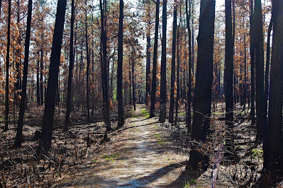 |
| Looking straight west down the trail into the early half of sunset. |
 |
| A view of the burned-out forest seems hopelessly desolate, save for the green needles high atop the longleaf pines. |
Eventually, I returned to the living, shade-giving broadleaf forest and knew that I didn't have far to go to the trailhead. At this point I was becoming tired, partly because I didn't bring much food but mostly because it was a bit of a shock to my body, going from no hiking all semester to twenty-two miles inside of three days. I made only a few brief stops, determined now to get back to the car, AC, and eventually campus. The trail wound back through some more limited pine savanna, past the pond, and back to the trailhead. For my first visit to Mississippi, the hike was a phenomenal experience, with dangerous bridges, closed trails, smoky skies, and a surprise trip through a brand new type of landscape: Charcoal.
 |
| Evening sun filters through dense canopy above a small hill on the trail. |
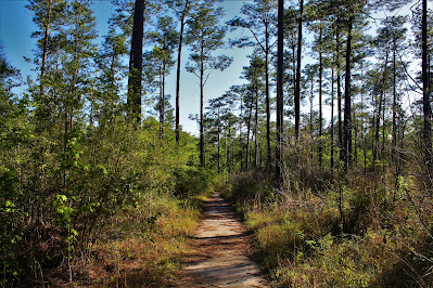 |
| A more limited (and living) section of pine savanna, within about a half-mile of the trailhead. |
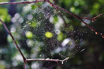 |
| A small orb web catches the oblique sunlight across from the small pond. |


No comments:
Post a Comment