Stuck in west Florida for another Easter break, I was eager to get some hiking done over the four-day weekend the college had graciously allotted me. I probably should have done more practicing and studying, but I had the bug to get out and
do something. My original plan was to head for Woodall Mountain, the Mississippi high point about six hours northwest, and stop at Dunn Falls, the state's highest waterfall on the way up (to make the long drive worth it). However, the falls are only publicly accessible on limited days, and those days were forecast to be rainy. I really didn't want to drive twelve hours in thunderstorms, and I wasn't totally certain that a trip that far would leave me with enough money to make it home at the end of the semester.
I resigned myself to seek other hiking opportunities, and after a bit of research settled on a rather disappointing answer. West Florida is home to a sizeable forested area in the Blackwater River State Forest. I had hiked here with friends the previous Easter, and visited again in October to see the impressive Red Clay Cliffs of Florida. Generally I try to visit new, unfamiliar areas, but with limited planning time and hiking opportunities, I returned to the state forest to hike the Juniper Creek Trail. This five-mile trail runs alongside the Big Juniper Creek, through dense forest and several swamps.
My phone's GPS got me a bit lost at first; it was trying to take me to the trail itself (or as close to it as I could drive) rather than the trailhead, and had me turning down more and more rural roads before I finally pulled over and figured out a better route myself. On the way in, it started thunderstorming, but the storms had passed by the time I got to the trailhead. They did, however, leave the humidity uncomfortably high, which would become problematic later.
The first half-mile or so of the trail leads to the Red Clay Cliffs, so I was already familiar with it, and passed the cliffs by. Soon after, it descended to run right alongside the creek, following it through denser forest for the next few miles.
 |
| A few live branches stretch out from a juniper stump (Juinperus virginiana) submerged in the creek. |
While trail paralleled the river, it often ran a few hundred feet inland through dense subtropical forest, and the river seemed to disappear through the trees and underbrush. At one spot was a little 'clearing' (section of slightly less-dense forest) filled with a number of different flowers.
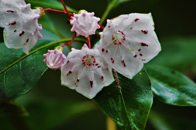 |
| Despite Florida's distinct lack of mountains, the trail was lined by mountain laurels (Kalmia latifolia) in full bloom. |
 |
| A dead standing tree was completely enveloped by blooming crossvine (Bignonia capreolata), just past its prime. |
The first mile or two of the hike was dotted with little side-trails leading to the river. I followed as many as I could at first, and discovered that spring rains had the creek considerably higher than normal, and many access points were underwater. With few good views at the end of most paths, and some of the unmarked trail dead-ending into the forest, I soon realized that it was unrealistic to follow all of them. I kept my eye out for any good, short trails, but mainly stayed on the main one for the rest of the hike.
 |
| A view down the Big Juniper Creek, with thin mist rising after the storm, from one of the few good access points. |
At maybe a third of the way to the trail's southern terminus (I hiked north to south), the path turned inwards, away from the creek, and through some swampy areas. These swamps appeared to actually be at a slightly lower elevation than the creek, with a natural wall protecting them from the river. They were mostly small, isolated swampy areas, unlike the more extensive swamps in nearby
Conecuh National Forest, but were more easily accessible from the main trail.
 |
| Juniper and tupelo trees grow covered in moss in one of the larger small swamps. |
 |
| Twisted roots stuck out from the mirror-like black swamp waters. |
After the first set of swamps, the trail headed away from the creek and into some hilly terrain. Blackwater State Forest is located in a region facetiously called the "Florida Mountains", home to the hilliest terrain in the state, and some of Florida's only compelling geographic features, such as the Red Cliffs,
Falling Waters Falls, and the highpoint
Britton Hill. As such, the trail was home to some actual elevation changes, small hills, gulleys, and channels lining the riverside. The forest here was generally less dense than near the river, but not by much, and the plant life became the primary attraction.
 |
| A small ball of fruticose lichen on the forest floor, maybe an inch across. |
 |
| A whole region of the forest was carpeted in these lichen balls. While lichens such as these generally grow on exposed rock or wood in the northeast, here they grow right out of the leafy ground. |
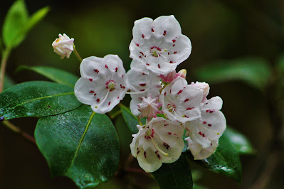 |
| Another bunch of mountain laurel flowers. Dozens of the shrubs covered the mid-April forest; back home, they don't bloom until late June. |
The trail returned after about a half-mile to follow the stream once again. It headed over some sandy areas and I ran into the first other people I had seen, a couple camping near the riverside. In the south, Easter is a warm enough time of year that people will camp over the weekend. The trail here approached the creek several times but I stayed mostly on the trail, deciding to save my energy and visit any good river spots on the return trip. I had underestimated the humidity - and the energy required to hike on level terrain - and was starting to run low on water, with a good six or seven miles left to go.
 |
| An eerie-looking sight along the river made me do a double-take. This old inflatable was hanging high up in a tree, probably placed there by floods, past thick underbrush a good distance off the trail. |
Soon, however, the trail wound away from the creek and into sparser forests. On higher, drier ground, longleaf pine dominates the inland Gulf Coast, and the remainder of the hike to the south trailhead was relatively uneventful, hiking through tall empty pine trees and underbrush of varying density. Occasionally the trail would wind back through some more dense forest, but never for long. I passed a number of 4x4 trails, marked as unnamed roads on some maps, that cut through the area, but didn't run into any offroaders.
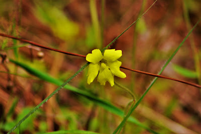 |
| A lone flower of yellow butterwort (Pinguicula lutea) was one of many small wildflowers that lined the path through the piney areas. |
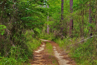 |
| A view down one of the 4x4 trails I encountered crossing the southern half of the trail. More mountain laurel blooms at left. |
 |
| A view of the trail through an area with more extensive underbrush. |
Towards the final half-mile, the trail one again plunged into dense forest, this time to stay. I could understand the dangers of getting lost in a forest like this; the underbrush was too thick to see more than a few feet ahead of me, and the terrain was flat enough that a lost hiker could easily end up walking in circles. I stuck close to the path and powered on, knowing that the southern terminus had to be near. Finally, the woods abruptly ended, and I found myself on the side of Indian Ford Road. I took a few pictures, downed my last bottle of water, and quickly returned to the forest for the five-mile slog back to the car. The road wasn't much to look at, but every hike needs a destination.
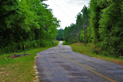 |
| Looking southwest down Indian Ford Road, across the street from the southern trailhead. Elevation in the distance is an example of the "Florida Mountains". |
Now that I had accomplished my goal of reaching the southern end of the trail - hiking the Juniper Creek Trail in its entirety - I could take some time to enjoy myself on the way back. Not too much time, of course, as I was out of water and wanted to get back to the car as soon as possible in the thickly humid weather. But enough time to pay attention in the denser sections of forest. Some of the areas in the southern mile or so of the trail were like walking through living tunnels made of trees and woody plants, and there were some interesting water formations in some streams that crossed the path.
 |
| One of several little caves that the trail carved through the dense understory. |
 |
| A small, unnamed tributary of the Big Juniper Creek had carved its own little valley into the sandy soil, surrounded by incredible forest. |
 |
| A view of a wooden bridge over a wider tributary stream. This was the best maintained of all the bridges and boardwalks of the trail, which I found strange given its relative remoteness. |
As I headed back into the open pine forests, I started to pick up the pace. These areas were open to the brightly overcast skies, which would dehydrate me faster than the dark woods, and were easier to move through due to the lower plant density. At this point I was getting tired, and keeping track of landmarks to see how close I was to the north trailhead.
 |
| Another 4x4 trail through some of the open piney areas. |
 |
| The pines in this section seemed relatively young, making me wonder if they're the result of recent replanting. |
As the trail began to parallel the creek again, I started hearing voices and loud music out in the distance. I was prepared to run into people, probably some group of kids spending the weekend partying at the river (it was getting into the evening already). These sounds eventually dissipated as I kept walking; they must have been down one of the truck trails or on private property nearby. I had the river all to myself as I stopped at a handful of side paths.
 |
| The Big Juniper Creek is characterized by large, steep sandbanks that occur at random along its banks. |
 |
| More mountain laurels. These are particularly easy (and pretty) flowers to photograph, and it was difficult not to stop at every bush. |
 |
| Some definitions of 'island' require a patch of land to be large enough to grow vegetation. This sandbank certainly qualifies, the only island I saw, which was curiously by the only spot I found where it was safe to walk right up to the water. |
Soon, I returned to the swampy area. I knew this was about halfway back, which was good, as by now I was thoroughly in grind mode, just trying to get back to the car. As I had my wide-angle lens out, I stopped at some of the swamps again for some (hopefully) better pictures. This area was home to a lot of boardwalks and wood plank walkways, meant to keep your feet dry in swampy areas. With the wet trail conditions, my boots were already covered in mud, but I appreciated the ability to keep my pants clean at least.
 |
| This small swampy area was all tupelos, too far from the river to see many large juniper trees. I took many swamp pictures on the return, but poor lighting meant this was the only one that was any good. |
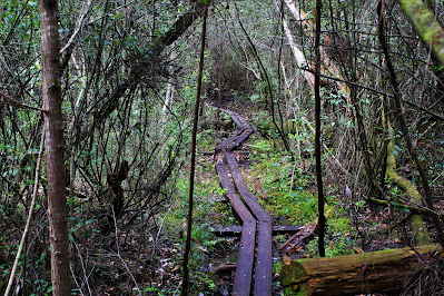 |
| One of the many wooden paths leading through the incredibly dense swampy forest. |
Eventually I emerged from the thick forest into another section of hilly, open longleaf pines, and knew I was only a half-mile from the car. At this point I was exhausted and quite dehydrated; I had brought far too little to drink under the false assumption that "flat = easy". I considered stopping by the Red Clay Cliffs again, since it was just off the trail, but some people were camping there and it would add a good amount of elevation to my trip. Soon I was back at the car, having completed the longest hike I had done at college thus far.
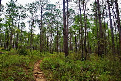 |
| The trail headed up a small hill where the forest began to open up again. |
 |
| A shot from just above the Red Clay Cliffs, where the trees were sparse, the underbrush almost nonexistent, and the car only a few minutes away. |


No comments:
Post a Comment