To be honest, the first of these mountains was actually hiked on June 5th, but I only wanted to put one date in the title. This past week I've occupied myself by hiking some of the mountains in my general vicinity which I've yet to explore. The first was Alander Mountain in the southern Taconics, followed by Snowy Mountain in the southern Adirondacks. Having thoroughly exhausted the Catskill Mountains over the past year, I'm moving on to new peaks.
June 5th bore my ill-fated attempt to hike Alander Mountain. There are two trails from the New York side of this mountain to its summit. I attempted to take the less popular trail, which approaches it from the south as opposed to the more popular easterly approach. Over a mile up the trail, and most of the way up the mountain, I found (much to my disappointment) that the trail was closed and had become impassable at high elevations. I had neither the time nor supplies to backtrack to the eastern trail, so reluctantly I returned to my car. I plan on trying Alander again at some point in the coming weeks.
 |
| Sunlight dances through beech leaves on Alander Mountain. |
 |
| Marker denoting the NY-MA border on Alander. A number of these were scattered across the trail. |
On Saturday I headed north. Originally I had intended to hike some of the Adirondack High Peaks, but the DEC's Adirondack Bulletin warned of icy summits and closed trailheads, so I elected to start farther south. A friend had recommended I hike Snowy Mountain some time ago, so I took the day to drive up there (a somewhat longer drive than I had been expecting) and climb it.
 |
| Fir trees near the summit of Snowy Mountain. |
The 3.5 mile trail from NY-30 to the Snowy Mountain summit is mostly flat until the last mile or so, at which point it steepens greatly for the summit approach. The summit is forested by mostly fir trees, with bits of krumholz at its windswept edges. The summit and area around it was also swarming with tiny flies, which seemed not to notice my liberal application of bug repellent, landing on me in the hundreds. The little things bite, something I didn't notice until far too late, and their bites are long-lasting and pretty nasty. Still, they were a small price to pay for the views from the summit.
The first overlook, actually below the summit, looks towards the south and east. The trail runs right through this grassy clearing, which sits atop a rock outcrop north of the true summit.
 |
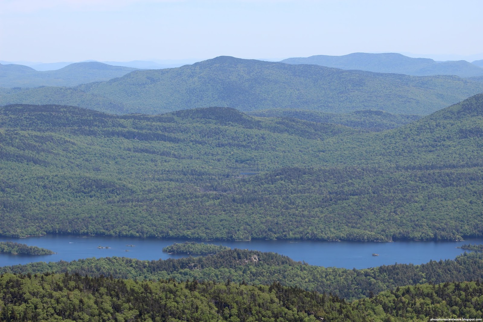
| Hills to the east over Indian Lake. |
 |
| Long Island, the largest island in Indian Lake, is at the bottom of this shot. |
 |
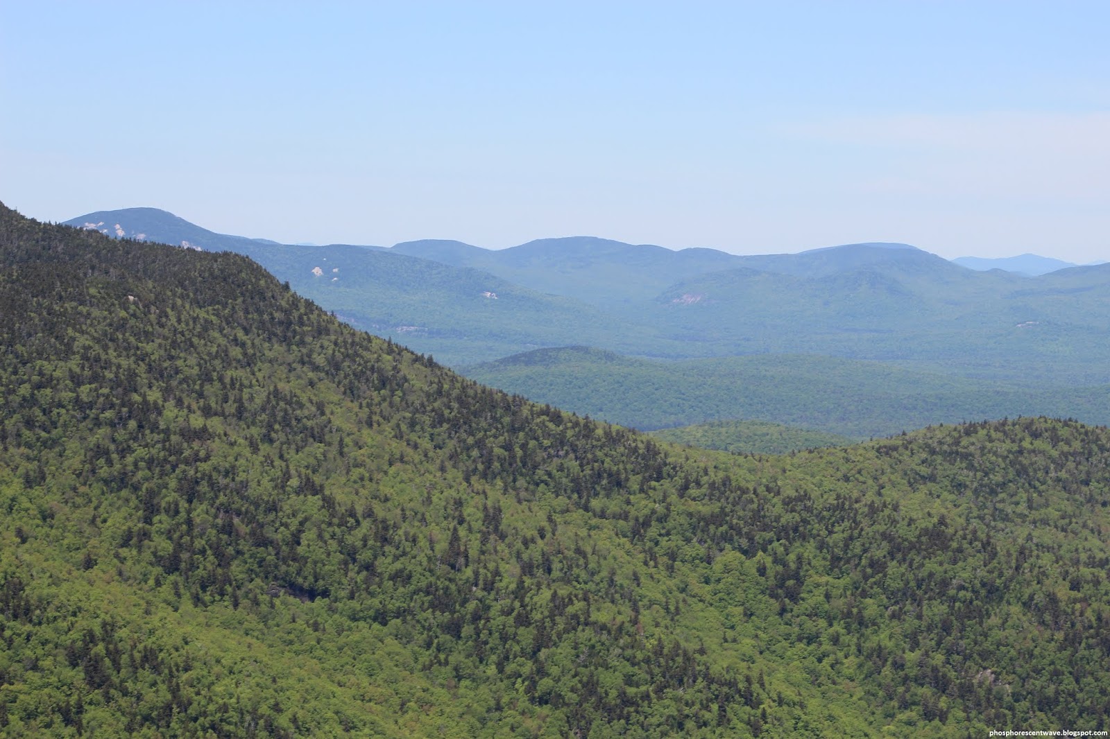
| A view of the expansive wilderness surrounding Snowy Mountain. |
 |
| The prominent hill in the center in Kunjamunk; I don't have the time or space to list all the others. |
A number of old herd paths traverse the summit and its surrounding areas, many overgrown and nearly impassable. One of these I followed to a northwest-looking overlook atop a cliff on the far side of the summit. This had a wonderful view of the wilderness, with the only sign of humanity in sight a dirt trail near a lake at the bottom of a valley. The rest was just untapped forest as far as could be seen.
 |
| Layers of mountains peer over the limb of Panther Mountain (L). |
 |
| View north towards the High Peaks region, some 40 miles distant. |
 |
| Panther Mountain was quite prominent from this overlook. |
 |
| More gently sloping hills characterized the terrain to the west. |
 |
| The vast expanse of seemingly endless spring forest was breathtaking. |
 |
| These little white flowers covered the summit; it was difficult to avoid stepping on them at times. |
A poorly-blazed trail leads from the east-facing clearing to the fire tower, which sits atop the actual summit. Compared to many of the fire towers in the Catskills, I found this one to be in pretty terrible condition. Grating was torn off, the pain scoured with graffiti (especially in the cabin at its top), and in many places railings were completely missing. Climbing the fire tower ironically seemed the most dangerous part of the whole hike. The cabin at its top didn't have glass in its windows, and thus offered a clear 360-degree view of the surrounding landscape. I stayed up there for some time; in the end it was very difficult for me to leave such an incredible view and return home.
 |
| The forests of the western Adirondacks were still bright green with new spring growth. |
 |
| Looking again to the High Peaks, far to the north yet still imposing in the afternoon haze. |
 |
| View northeast over Indian Lake. A stretch of NY-30 cuts the wilderness towards the bottom. |
 |
| From left to right: Haystack, Gothics, Pyramid, and Sawteeth, four of the Adirondack High Peaks, at a distance of forty miles. |
 |
| Spruce Mountain occults Blue Ridge Mountain in this southward view. |
 |
| Buck Ridge, with its soft green slopes, made for a lovely view to the southwest. |
 |
| A lake on the Squaw Brook in the valley to the west. Note the truck path leading to it. |
 |
| Swampland along the Squaw Brook breaks an otherwise clean expanse of forest. |
 |
| Looking north to the distant High Peaks. Mount Marcy, the highest mountain in the state, rises at their center. |
 |
| Looking northeast towards the mountains of the upper Hudson River area. |
 |
| Looking east over Indian Lake and the hills beyond it. |
 |
| Looking east towards the Siamese Ponds area and Gore Mountain (R). |
 |
| Looking southeast over Indian Lake towards Puffer Mountain. |
 |
| Looking southeast over Long Island. The Green Mountains of Vermont are visible in the background. |
 |
| Looking south over Dug Moutnain. Black Dome, all the way back in the Catskills, is visible in the distance on the right. |
 |
| Looking southwest over Lewey Lake. |
 |
| Young cones atop a fir tree, as seen from the fire tower. |


No comments:
Post a Comment