It was the second day of a week-long solo trip through the midwest to bag state highpoints on my last fall trip to college. I had just crossed back into the United States after a failed attempt on Ishpatina Ridge, the highest point in Ontario, which had just freed up an extra day in my tight schedule. I hadn't planned to make Mount Arvon, Michigan's highpoint, until the next day, but I was already in Michigan, so I pulled over at a McDonald's in Sault Saint Marie to figure out what to do (and grab some lunch).
An earlier iteration of this trip involved spending a day in Pictured Rocks National Lakeshore, making the most of my time in the Upper Peninsula, but I threw out the idea due to timing and lodging issues. Now, however, I was hopeful that I might be able to at least stop there. Google Maps gave remarkably short estimates for travel times, and it looked like I might be able to not only stop but also hike in the park. I wasn't sure quite where to sleep, but I considered it possible that I might even make it to Mount Arvon, on the other side of the UP, in time to camp at the summit. With a new plan in store, I was excited to get back on the road.
I had never been in Michigan before, and this was the first of twelve states I would visit for the first time on this trip. I found the UP to be a gorgeous place, covered in forests that were very similar to those back in New York. I took Route 28 as far west as Seney, and the road passes through mile after mile of forests and bogs, each topped with evergreen trees that gave the horizon the form of a saw.
.JPG) |
Forest along Route 72 north of Seney.
|
From what I could tell, I approached the park from the "backwards" direction, starting at Grand Marais and working my way west. Most of the built-up touristy areas are on the west end of the park, near Munising. My first stop was at Sable Falls, where I was quickly pulled out of the peaceful isolation and loneness that I had experienced in the Canadian wilderness. It was the last weekend of the summer and the falls, though beautiful, were filled with tourists.
 |
| Seney Falls from the main overlook. |
Perhaps seeking solace, I followed a much less used trail that continued uphill from the falls. This led me to a great sand dune and, at its top, a stunning view of Lake Superior. The sand dune stood about 100' above the narrow shore below, and the water was so clear that I could see clear to the bottom of the lake for some distance. .JPG) |
| A warm, sunny day on Earth's second-largest lake. |
 |
| Footsteps in the red sand left interesting crater-like depressions. |
Knowing that more extensive, dune-oriented hiking trails existed in the area, I quickly returned to the car, eager to continue my impromptu exploration. I was flying by the seat of my pants on this whole leg of the trip. While I had researched Pictured Rocks in depth over the summer, I hadn't planned on stopping there, and I had no cell service in the park. I didn't really know where anything was or how long any hikes were, so road signs were more or less my only guide to the area.
Shortly down the road, I spotted a trailhead at Grand Sable Lake and pulled over. A trail evidently stretches north from here, climbing up Grand Sable Dune in a 2.5-mile round-trip hike to the lakeshore (or, rather, 150' feet above the lakeshore). I didn't know this, however, so I just jumped out of my car and started climbing, prepared to go until I got tired.
It was hot and extremely windy out, and my first immediate barrier was sand. While many of the dunes were covered in scattered pine trees or tall grasses, many others consisted simply of open sand, and it frequently got in my eyes and, more problematically, my camera. However, the landscape was beautiful enough to make it worthwhile. The trail winds through forests, fields, and flowers, all situated atop shifting sandy dunes, until eventually reaching the end of land, where all the was left was sand.
Climbing the sand in my hiking boots took some getting used to. I imagined that, when people one day walk on Mars, their suits will have to be specially designed to deal with the sandy terrain. Every step of the way felt like I was an adventurer exploring some wilderness, an impression made stronger by the fact that I didn't see another soul on the entire hike.
 |
| The narrow trail winds through wild grass fields along Grand Sable Dune. |
 |
| The dunefield drops abruptly where it meets Lake Superior. |
.JPG) |
| View of one of the more bare dunes. |
 |
| Overlooking Grand Sable Lake from a high dune on return. |
I was more dehydrated than I had been expecting when I returned to the car. I downed a Gatorade, searched in vain for cell service, and continued on my way, eager to visit as many unique spots in as little time as possible.
My next stop would be the Log Slide Overlook, one of the more popular spots in the park, and one that was expectedly crowded on a Sunday afternoon in August. A quarter-mile walk took me from the parking area off of Route 58 to an impressive overlook, again about a hundred feet above the water. To the west (left) rose forested bluffs and a lighthouse in the distance. To the east (right), an arm of barren sand hills extended out into the lake. Below me was glittering water and a beach dotted with footprints.
 |
| Looking west, where the terrain gradually descends to meet the shore. |
.JPG) |
| Clear blue water below. True to its name, a log seems to have slid down the slopes and into the sand. |
 |
| Desolate sandy bluffs, some of which I had just climbed, extend to the east. |
Some people were climbing down the steep sandy slopes to try to reach the shore. This seemed somewhat dangerous, given the high grade and instability of sand. I briefly considered trying, but I knew that in hikers I would never be able to climb back up. This is one rare 'climb' where flip-flops may be the most appropriate footwear.
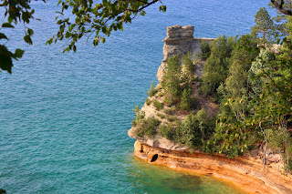
Moving onwards, I drove farther west to my last stop of the night, the Miner's Castle. This is by far the most well-known spot of the park, attracting tourists from around the world, and I would suggest a good portion of Americans would recognize the rock formation, even if not by name. Most promotional pictures of the Pictured Rocks include Miner's Castle, and most boat tours (a popular method of exploration that was unfortunately infeasible for my trip) start with a close pass of the formation.
There are two main spots people visit at the Miner's Castle. The first is an overlook, just near the visitor center, that views the formation. The second, about a quarter mile of staircases away, takes you right up to the rock itself, although climbing it is against the law. The staircases also host distant views of colorful cliffs and arches to the west, accessible only by boat, that give the park its name. While I was there, a personal boat buzzed by the formation. If I ever return to the park, I'd like to take a boat tour.
 |
| The quintessential view of Miner's Castle, from the first overlook near the visitor center. |
 |
| Rocks to the east over the lake. Note the tour boat at left. |
 |
| Another (unfortunately distant) view of the truly astounding rock formations. |
After a briefly getting lost in the multi-story visitor center in desperate search for a bathroom, I climbed back into the car and continued on my way. Now it was time to race the dying sunlight to the summit of the state.

.JPG)

.JPG)


.JPG)


.JPG)


No comments:
Post a Comment