This summer I took a very long trip and, due to the sheer amount of pictures and stories to share, I stopped updating this site. I'm trying to get back into it now.Several years ago, I noticed that a number of state highpoints across the midwestern United States form a roughly north-south line. I thought that I might conceivably be able to bag a number of them in a single, albeit long, road trip, but with my focus on college, I figured it wouldn't happen anytime soon.
However, as I looked towards my last fall semester, I decided to attempt this audacious solo trip. I saved money all summer to be able to afford the lengthy expedition and planned to camp most nights to further minimize costs. I planned for a trip spanning eight days and grabbing eight state highpoints, along with several other points of interest, all very loosely planned to allow for improvisation in the event of weather or car problems.
Day One was mostly travel-related. I planned to travel northeast across New York, grab a county highpoint, and do some hiking in Whetstone Gulf State Park, which had been on my wishlist for some time. Afterwards, I would drive into Canada as far as Sudbury, Ontario. There I would camp at the foot of the provincial highpoint, Ishpatina Ridge, and complete the twenty-mile bushwhack the following day.
Reality would be a little different.
I made it out of the house by around 530 AM, quite nearly a personal best for college departures, and took a lovely drive along empty roads in central New York through the morning. The sun gradually came up and the fog gradually dissipated as I headed towards my first destination: Gomer Hill, the Lewis County highpoint.
.JPG) |
| Clouds at sunrise in Herkimer County. |
 |
| A maze of gravel roads leads to Gomer Hill. |
Unfortunately, I found the access road to Gomer Hill was blocked off, so I continued driving and headed to Whetstone Gulf. I parked at the park's less-often visited west end and followed the Gorge Trail inwards for about a mile. This trail follows the edge of the steep canyon, where moss and ferns cover terraced black rocks in an atmosphere almost reminiscent of a jungle. Rainy conditions had turned the Whetstone Creek into a rushing river that could be heard even from the top of the gorge..JPG) |
| Spruce/hemlock forest typical of the Tug Hill area. |
 |
| Signs posted on some of the less stable parts of the trail. |
 |
| Dark rocks form the steep cliffs on both sides of the gulf. |
After leaving Whetstone, I headed northeast to the town of Ogdensburg. Here I stopped for lunch and then took the Ogdensburg-Prescott Bridge into Ontario. I had travelled internationally before, but this was my first solo trip out of the country, and I was a little nervous about it. I knew that my phone and likely my credit card wouldn't work, but my first priority would be just getting into Canada, which would turn out to be more difficult than expected.
 |
| Entering Canada on the northwest side of the bridge. |
"I'm going to need you to step out of the vehicle."
Upon my arrival, I attempted to explain the concept of highpointing to the customs agent, something many highpointers have struggled with in the past. She seemed skeptical of my plan to reach Sudbury - a ten-hour drive - by evening, and the fact that my entire life was packed in the backseat for college probably looked less than benign. I was pulled aside for an inspection where I explained my plans to additional agents and waited in the facility for about half an hour.
I think the second set of agents looked up Ishpatina Ridge during their inspection because I saw them all on their phones out there. They thoroughly tossed my car, and many of my clothes were left unfolded, but they were quite polite and let me go afterwards. The ordeal had set me back on time but I had planned on being stopped. I imagine they don't get too many young solo travelers at the border crossing.
Now I was alone in Canada, and my next step was to get some cash before my card stopped working. I pulled out about $150 from an ATM near the border, enough for gas and supplies for the next day or so, and I was on my way.
The drive across northern Ontario was fairly boring. I took the Trans-Canada Highway north over the Great Lakes towards Sudbury. This area is probably the most remote I've ever driven through, sometimes going over an hour without passing through any towns. The highway was surrounded by endless and beautiful lakes and spruce forests, but traffic on the two-lane road and wet, foggy conditions made the trip seem monotonous pretty quickly.
 |
| Lakes and hills in the rain from a rest area near Rolphton. |
 |
| Lake Nipissing from an overlook in North Bay. |
I made it to Sudbury by early evening. I grabbed dinner, stocked up on gas and supplies, and messaged my family using WiFi from local businesses. I used that same WiFi to get directions on my phone to the Ishpatina Ridge trailhead, located down a maze of rough logging roads several hours to the north. I bade civilization goodbye for the night and headed out.
"I think this crosses the line from dedicated to crazy."
North of the town of Capreol is a rough dirt logging and mining trail called Portelance Road. Running parallel to the Wanapitei River, this road is wide but extremely bumpy, with deep ruts and potholes that worsen the farther you go. I couldn't move nearly as fast on this road as I had projected, and soon I was driving in total darkness. Every few minutes I hit a large bump that pushed my car around and became acutely aware that the deep, frigid river was only a few feet to my left, hidden behind a thin layer of bushes.
This road was largely empty, but it was a weekend, so there was some activity. It was very late at night went I encountered another car travelling south on the road. I imagine we were both very surprised to find other people this far out. This presented a problem, as the road was pretty much one lane at this point, and the river inches to the west didn't provide much breathing room. I ended up pulling into some tall grass along the road, giving just enough clearance for the other car to pass.
 |
| Driving on Portelance Road around 10 P.M. |
Unbeknownst to me, my mission was somewhat doomed from the start. I had planned my route based on satellite maps, showing a logging road leading to the trailhead from an intersection on the east side of Wanapitei River, just before a wooden bridge on the main road. However, in the time since those photos had been taken, a new road had been cut through the forest far to the south of the old one. Many trip reports online claim that the trailhead is easily accessible by passenger car; they presumably refer to this southern access route.
The more northerly road was far less accessible. The start of the road (or, more accurately, trail) contained grass in the middle half as high as my car. Many other areas were extremely washed out, with little dirt remaining and lots of mid-sized rocks. Despite my best efforts, there were a few times I bottomed out, and eventually I reached a point where the road was so steep and so rocky that my tires couldn't get enough traction to keep moving, similar to the approach to Sisson Hill earlier in the summer.
At this point, I had to reevaluate. I was about a three-hour drive on sketchy logging roads from the nearest town. I hadn't seen another car in about an hour. It was already 11 P.M., and even if I made it to the trailhead, I wouldn't get enough sleep for the one-day push I was planning. Even if my phone worked in Canada, there was no cell service out here. I was driving on roads that were more suitable for an ATV than a sedan, and a flat tire or damaged undercarriage would be disastrous. Clearly, I had done something wrong.
I carefully backed the car up to a flat area down the trail and parked for the night. On a Saturday night, I didn't have to worry about logging trucks flying down here before I was awake. I stepped out of the car to relieve myself and, with the engine off, realized how truly remote I was. My fight against the road had quieted all the wildlife, and even the frogs and crickets were silent. There was darkness in every direction; the only light came from a handful of stars visible in the small gaps between the trees. The only sound was a slight breeze in the treetops. It was both extraordinary and terrifying.
I slept in the car right on the road with a canister of bear spray in my lap. I hadn't realized how terrifying the drive had been up until then, and my brain and body took a long time to unclench. Adrenaline is a stimulant and I had a lot of trouble sleeping that night. The temperature dropped down to the upper 30s, which didn't help my sleep any.
At around 3 A.M., I woke up with an odd terror that I wouldn't make it back to the main road in the morning. Half-asleep, I managed to turn around and drive back to Portelance Road, where I went back to sleep for the night. There are some trips where it seems like God is working overtime to keep me safe, but the fact that I made it back without any getting stranded or damaging my car I would consider to be a legitimate miracle.
I woke up at sunrise that morning and, while not feeling particularly rested, I began the long, bumpy ride back to Sudbury. I wasn't terribly disappointed that I didn't make it to the mountain; I knew I'd be back one day, and I had already gotten more of an adventure than I had expected. The drive out was beautiful. Fog was rising off the river, the sky was gradually turning from grey to red to blue, and I could actually see the gorgeous forests and swamps and ponds and hills that I had obliviously passed by the previous night.
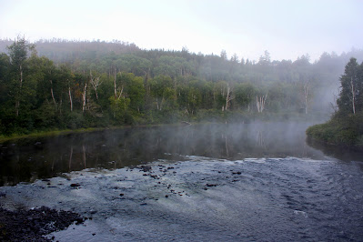 |
| Fog floats along the Wanapitei River in front of a birch forest. Most of the trees here were either conifers or birches. |
 |
| Looking towards sunrise east down a bend in the river. |
"What in the hell are ya doin' up there?"
While I was content to let the mountain go, I still wanted to climb something in Ontario. I had been in the car for far too long without any breaks. At one pullout near a bridge, I found a small granite hill, blasted in half and covered with some graffiti. I quickly scrambled to the top of the hill, earning a more extensive view of the largely fog-enveloped wilderness.
Remarkably, as I was up there, a truck carrying some ATVs pulled into the parking area. A man stepped out and quickly spotted me on top of the hill. He was surprised to find someone out here from America, and once I had climbed down, I explained a little bit about my trip to him. I get the impression that most locals aren't that aware of the highpoint, which isn't too surprising owing to its remoteness. I snapped some more pictures and we both drove on.
 |
| The granite hill I scrambled up. I was surprised to find graffiti this far out, although this area was much nearer to civilization than where I had slept. |
 |
| View of the landscape from the top of the hill. |
.JPG) |
| Fog and spruce trees over one of the Twin Lakes, seen from an intersection at the southern end of Portelance Road. |
I stopped before getting back to civilization to bid the wooded wilderness goodbye. I was so calm and serene and beautiful out there, and I vowed to return one day (and actually make it to Ishpatina Ridge), but I was still on Day Two of a long road trip and needed to get moving. In the second of several miracles over the course of my trip, I managed to find my way back to Sudbury without directions, and once I was there, I found WiFi and figured out how to get back to America.
Getting back to the States was fairly easy. Once I was back on the Trans-Canada, I headed west until I reached Sault-Ste. Marie. All the way, however, I was rearranging my trip in my head. An eight-day solo trip like this goes through many iterations during the planning phase, and everything has to be planned very tentatively. Suddenly, I had a free day in my schedule that I hadn't anticipated, so I started reconsidering some of my scrapped plans for Michigan's Upper Peninsula.
.JPG) |
| View of the Mississagi River from a rest area east of Iron Bridge. Note the early autumnal colors forming in some of the trees. |
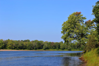
The first destination to come to mind was Pictured Rocks National Lakeshore. I had planned to stop here early in the planning stages, but the lack of affordable hotel rooms and problems with scheduling forced me to scrap the idea. Now, however, I would be getting to Michigan far earlier than anticipated, and I might have time to stop there along the way to the state's highpoint, Mount Arvon. There was still the issue of sleeping, however, and I had no concept of driving times here, so I delayed any concrete planning until I was back in America with cell service.
 |
| Waiting in traffic at the border. |
I was vaguely concerned about getting back into the country because I still had most of the supplies I had purchased for the planned Ishpatina hike, and I had never needed to declare anything before. After about a half hour in traffic, I made it to customs, where the agent told me that the handful of groceries I was carrying didn't require any complicated paperwork. After a handful of questions, he let me through without any major problems. I was home, in a manner of speaking, and now I could really plan the next leg of my trip.
.JPG)
.JPG)

.JPG)


.JPG)

No comments:
Post a Comment