South Carolina: State High Point 20/50. Elevation 3553'. Solo winter ascent via Briar Bottom. 5.64 mi, 1312' gain, 1h46m RT.In my college-trip quests to highpoint the Southeastern states, South Carolina had somehow evaded my attention. The state is a few hours out of the way of my normal route, has a reputation of hostility to northerners, and an ex-girlfriend lives near the highpoint, but none of these were keeping me away. Rather, scheduling with regards to semester start and end dates, weather, and sunrise/sunsets in the winter months made it impractical to climb Sassafras Mountain before this week.
Despite its negative circumstances, the last-minute rescheduling of my trip down this semester opened the window to climbing the South Carolina highpoint, and to visiting the state for the first time. After visiting DC's Point Reno the day before, I got a hotel in Asheville NC and prepared to grab my last East Coast highpoint.
Like many southern highpoints, there's a road to the summit of Sassafras Mountain with a recently-constructed observation deck. As always, I planned to hike to the summit anyway; driving to the top always has always felt like I didn't properly 'earn' the peak. There are two more 3000' peaks near the summit, Whiteoak and Hickorynut Mountains, and I briefly considered hiking these as well, but I also did want to get to college eventually, so I settled on just the highpoint. If I ever get around to hiking the South Carolina 3000' peaks, I'll just have to come back some other time.
I stocked up on food at the hotel, then got lost a little bit which set back my start time significantly. By nine I had parked at the trailhead for Briar Bottom Falls along the F. Von Clayton Memorial Highway. It was 30° F when I arrived, chilly for SC even in January, and I talked a bit with a family there who was on their way to the falls.
The trail up Sassafras Mountain is fairly straightforward. Due to the road, it isn't used too much, and it's not very well-worn, although I had no difficulty following it. The first third is pretty steep, climbing up towards the top of the ridge. The second third is, in my opinion, the most beautiful, with the thin trail winding around the edges of hills and gullies with more gradual elevation gain. The final section climbs through grassy young pine forest near the summit, crossing the summit road shortly before reaching the top.
 |
| The trail in the ridgetop pine forest in the final third of the hike. |
 |
| Some boulders below the summit. There weren't many rocks, streams, or other interesting features along the three-mile ascent. |
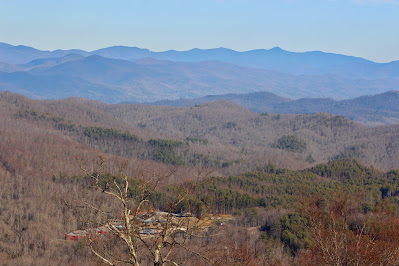
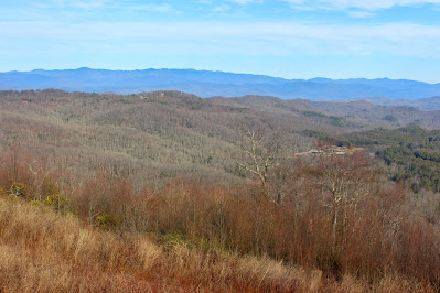
I arrived at the top of South Carolina a little after ten in the morning and was treated to an expansive view of hills to the east and mountains to the west. The summit lies along the state line between North and South Carolina, and the line is marked where it runs through the observation deck. I stopped on the deck for quite some time to take pictures and enjoy the extensive views. |
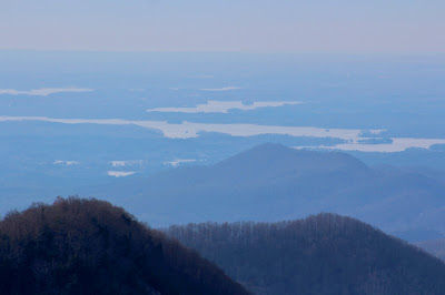
| Looking southwest past Round Top (L) and Caeser's Head (R) towards Lake Keowee. |
 |
| High Knob intersects the distant view of Lake Jocassee to the southwest. |
 |
| Many lakes, all artificial, dot the hilly lowlands on the South Carolina side of the mountain. |
 |
| North Carolina's Toxaway Peak rises prominently to the northwest. |
As I walked around on the platform taking pictures, a young couple arrived and began circumnavigating the structure. They explained that, while visiting the summit the previous day, their son had lost his glasses. I helped them in the search to no avail, and after ten minutes or so, they left to search the parking lot lower on the mountain, leaving me alone at the summit once more.
 |
| The popular Mount Pisgah, 25 miles to the north, is the pointiest peak in this view towards the western Smokies. |
 |
| Nearly sixty miles northeast, North Carolina's Mount Mitchell is visible just to the left of center. Rich Mountain is the much closer peak to its right. |
 |
| A close view of Lake Keowee and its surrounding hydrological features. |
 |
| The foothills of the Appalachians drop sharply in elevation just to the southeast of Sassafras Mountain. |
 |
| Seemingly endless peaks fade into the distance looking southwest along the NC-SC line. |
 |
| The easy-to-spot cliffs of Whiteside Mountain (center) stand out above the highpoint's grassy summit ridge. |
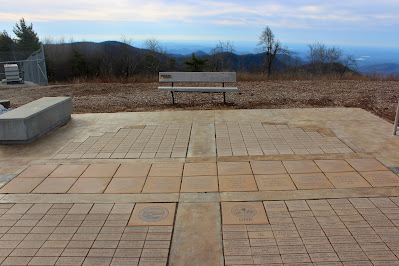
After taking a seemingly infinite amount of pictures of the seemingly infinite mountains, I took some time to walk around the summit a bit. There are some communications towers near the observation deck, along with a plaque, a display, and a bench placed by the Highpointers Foundation. I was searching primarily for the USGS survey marker, which is located in a cylindrical concrete block to the east of the observation deck. |
| A wide-angle shot of the Appalachians, looking towards the North Carolina side of the border. |
 |
| State map and compass marker on the observation deck. The line running behind it denotes the border. |
 |
| Sassafras Mountain, South Carolina. Elevation 3554'. State high point 20/50. |
 |
| Sponsor and memorial bricks below the Highpointers Foundation bench. |
 |
| USGS survey marker denoting the highest natural point in South Carolina. |
I spent nearly half an hour at the summit, which was far longer than I had planned, but well worth it. It had been a long time since I had summited a state high point that was home to good views in weather that allowed me to see them. However, I did have other plans for the rest of the day, so I headed back down the mountain the way I had come. I ran into one other hiker on his way up with a few dogs, but otherwise the place was surprisingly empty for a beautiful Saturday morning. That was fine by me; I'd always rather have the trails to just me and God. |
| A view towards Hickorynut Mountain from a rock outcrop below the summit. |
 |
| The poorly-worn trail winds its way around rilles in the mountainside on descent. |
I made it back to the car by noon, which meant I still had time to hit my secondary target for the day: Georgia's Tallulah Gorge. I took backroads all through the hills of South Carolina, which made for a beautiful (and rarely-trafficked) drive. Tallulah Gorge is a 900' deep canyon along the Tallulah River near the GA-SC line, home to a series of waterfalls, accessible through overlooks, stairs, and a suspension footbridge. It added two miles and over a thousand feet of elevation gain to my trip, but the incredible scenery was well worth both the walking and dealing with Saturday crowds at a popular state park. |
| Looking southeast from Overlook 1, near the deepest point in the gorge. |
 |
| Rocks and cliffs surround the river at the gorge's bottom, accessible through a relentless series of steep stairs. |
 |
| Hurricane Falls, seen from the bottom of the gorge. The falls' moisture reveals the dark red coloration of the local rocks. |
 |
| This suspension bridge hangs over Hurricane Falls and connects the two sides of the gorge. |
The rest of the trip to college was as uneventful as one could hope. I drove through a spot on I-85 where a tornado had recently cut through and drove through intermittent rain in most of Alabama. By seven in the evening I was back on campus, unpacked and settled in in time to get dinner and relax a bit. No more real mountains until May.


No comments:
Post a Comment