In late April, the weather began to heat up, so I walked a five-mile loop consisting of several highways and backroads in central Greenville NY. This route took me through the center of Greenville, past a number of historical locations, and through farmland with some excellent views towards the mountains in the south.
Roads Walked: NY-81, NY-32, East Red Mill Rd/CR-35, Red Mill Rd/CR-35
 |
| Historical marker along NY-81 outside of Greenville. |
 |
| Shallow rapids in the Basic Creek. |
 |
| A short waterfall marks the former spot of the long-destroyed Hickcock Grist Mill on the Basic Creek. |
 |
| Patches of daffodils sot the roadside in central Greenville. |
 |
| Three of these oddly-shaped turbines sit atop a hill near the center of town, erected about a decade ago. |
 |
| Welcome signs at the edge of town display the Blackhead Range, which is prominently visible from most of Greenville. |
 |
| View through the center of town. Sidewalks line Route 81 as it runs towards the only stoplight in the town limits. Route 26 continues straight while NY-81 heads right past the intersection. |
 |
| A historical marker at the edge of the town green gives a brief description of Greenville's history. |
 |
| This old church building has had various uses over the years, but currently sits empty. |
 |
| Power lines and heat waves obscure the eleven-mile view to Round Top. |
 |
| At 40 ac, Carelas Lake is the largest body of water in the town of Greenville. |
 |
| Some sort of flowering tree was in bloom on the peninsula inside Carelas Lake. |
 |
| Distant Mount Hayden looms over power lines and grey forest. |
 |
| A bit of spring color touches the trees on the east side of Carelas Lake. |
 |
| Route 32 heads south under Stoppel Point's watchful ridge. |
 |
| Power lines bisect this twelve-mile view of Stoppel Point. |
 |
| Windham High Peak's summit forms a soft inverse 'V' shape against the cloud-whitened afternoon sky. |
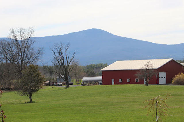 |
| Windham looms over a farm on East Red Mill Road. |
 |
| Late April snow still clings to Blackhead's upper slopes. |
 |
| Blackhead, Acra Point, Black Dome, and Thomas Cole Mountain complete this pastoral scene on East Red Mill Road. |
 |
| Over the crest of a hill, a little bit less of the mountains can be seen. |
 |
| A single boulder juts out from an otherwise empty field. |
 |
| Windham presides over some less cultivated fields farther down the road. |
 |
| The still-standing Red Mill, an 1845 structure on the Basic Creek that gave its name to the road along which it sits. |
 |
| Tiny periwinkle-colored flowers filled the lowlands along Red Mill Road. |
 |
| A closeup on some of the downward-blooming flowers. |
 |
| Tufts of greening grass brave the high water of the Basic Creek at springtime. |
 |
| A small airplane, landing gear deployed, flew overhead on approach to the Freehold Airport as I neared the end of my walk. |
 |
| Several old vehicles like this one are scattered in the forest near the Basic Creek Fishing Area. |


No comments:
Post a Comment