Last Wednesday I walked Clay Hill Road, a short road about 1.5 mi in length located between Oak Hill and West Durham, resuming my task of walking every road in the town of Durham. This road connects NY-81 with NY-145, and is known for its low shoulders, massive hills, and very twisty turns, with accidents fairly common along its unguarded length. I took care with this hike, always staying alert and wearing a high-visibility vest. Weather was fairly cold, in the upper 20s, but conditions were clear, and a pair of gloves and a sweatshirt were sufficient protection from the elements.
The area I parked was near the Brandow Memorial Park, a small park in Oak Hill near the road's end used for a number of activities during the warmer months. From here I walked southward down the road, up its steep incline, rising from the forested low end to the most pastoral southern portion.
 |
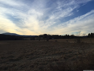
| Field looking east. |
 |
| Uncultivated field, again looking east. The curve is natural, not a camera artifact. |
 |
| Juniper trees line an ATV path through an abandoned field. |
I made good time reaching the far end of the road, where it met with NY-145, and headed back towards the parking spot. The view behind me, towards the southwest, at sunset was spectacular, with clear shots of the northern Catskills in the sun's light.
 |
| Like a diamond the last bit of sunlight peeks over Mount Hayden. To its right and left are mounts Ginseng and Pisgah, respectively. |
 |
| Mount Pisgah watches over open hayfields under a spectacular sky. |
 |
| View of Windham, Zoar, and Ginseng in the dying light of evening. |
From the mountain view, I continued down the road, stopping again at some more easterly-facing open fields.
 |
| The wavy terrain of the fields here looked quite interesting. |
 |
| Here you can see the harvested hay lined up against the edge of the field. |
Upon returning to the parking area I found a public access point to the Catskill Creek, which parallels the bottom portion of the road on its way through the Squirmer Valley. I stopped here to look at the waters, which were unusually high and rapid due to heavy precipitation over the past few days.
 |
| Looking upstream, towards the bridge on CR-22. |
 |
| Looking downstream, near the remnants of some destroyed concrete structure. |
 |
| Looking straight ahead. Note how black the waters appear. |
I've already completed the next two walks, and I hope to complete several more this week, which I look forward to including here.


No comments:
Post a Comment