It was the fifth day of my week-long midwest solo roadtrip, and I had just left Panorama Point, the highest point in Nebraska. My next highpoint stop would be in Kansas, but getting there involved driving the length of Colorado, and I wasn't going to spend hours in a state - on my first time there, no less - and not stop somewhere. Eastern Colorado is a pretty desolate area, home to flat brown plains and not much else. Hidden in these plains, however, is the Pawnee National Grassland, home to the Pawnee Buttes, a pair of 200' tall buttes that rise dramatically out of the surrounding flatlands.The trail to the buttes was about five miles long round-trip, and given a 100-degree forecast, I didn't plan on hiking the whole length of the trail, but I definitely wanted to visit and at least photograph the buttes. Buttes are one of those rock formations that are quintessential to the American west, and I wanted to see at least one on my great western roadtrip.
My GPS took me on a maze of rocky, dusty ranch roads that seemed to go on forever. The buttes are miles from any major road, and the approach took probably around an hour from the somewhat less isolated Panorama Point. The final road to the trailhead was quite rocky and washed-out, and I was little worried about driving it, but my car made it without incident to the remote trailhead.
I parked the car and, after a moment enjoying the view, decided to just hike out a little bit and see how long it took me to get tired. I was planning on doing a lot of desert hiking over the next few days, and I figured a place like this might be a good place to test out my endurance in hot, unshaded conditions. Between me and the buttes, the trail traversed dry open plains and climbed a small mesa, so I set my sights on that and headed out.
 |
| The grassy and empty landscape of the Pawnee Grasslands. |
 |
| Approaching the mesa from the south. |
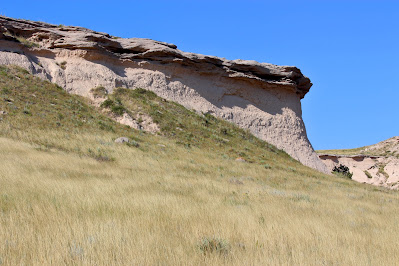
The grass on the plains was unlike anything I had hiked in before (a recurring theme on this trip), consisting of dry grains, succulents, and small cacti, and seemed much more imposing than the fields I was used to back home. Climbing into the mesa was a lot of fun, and involved some limited scrambling on a very rocky trail. Once on top, I had an excellent view to the buttes in the east and the wind farms to the west. The edge of the mesa at once point forms a small canyon with a barren floor, and the whole area looked sort of like a poorly-rendered video game. There were steep drop-offs at the mesa edges and I left the trail for awhile here to wander around the fascinating environment. |
| Sand-colored rock formations around the mesa, with a nearby wind farm in the background. |
 |
| Dry channels cut through the plains below, giving evidence of runoff in the wetter season. |
.JPG) |
| The mesa walls near the north side of the small canyon. I was annoyed at my camera's inability to properly capture the beauty of this particular spot. |
Once I reached the far edge of the mesa, I had a decision to make. I had walked about a mile so far, which meant it was another mile back to the car, or alternatively another mile to the first butte. It looked so tantalizingly close, and the trail between here and there, while exposed to open sun, looked very flat and straightforward. I was feeling pretty good and, despite the fact that I hadn't brought any water with me, wasn't dehydrated in the slightest. It was already over 90 degrees, but the air was so dry that I didn't really feel it. So I decided to push on and hike out to the buttes themselves.
.JPG) |
| Looking back towards the mesa while descending its eastern side. |
.JPG) |
| Towering walls rise without warning out of the prairie. |
.JPG) |
| A view towards the buttes across the open plain. |
Thankfully, my prediction of the hike out to the buttes was correct, and it was pretty easy going. It was fascinating to me to see how the appearance of the nearer butte changed as I approached it. The butte is shaped somewhat like a ship, and from the approach I was viewing its wide side, but the closer I got, the more narrow the rock formation appeared to be. As I passed by my closest approach, I found myself wondering if it would be possible to climb to the top. The rocks looked rather crumbly here, and I certainly wasn't going to try right then, but my first instinct was to try to routefind up the side of the butte.
.JPG) |
| The wide side of the butte seen on approach. The more distant eastern butte is just to the right. |
 |
| A closer view, showing the narrow, ridge-like shape. |
The hike out to the farther butte now seemed like nothing more than a short walk. This butte seemed a little more rounded, and didn't appear to change shape as I approached. The trail crosses through private land here, so I didn't stray in either direction until I reached the butte itself. The trail sort of peters out here without any clear terminus, so I naturally kept going and scrambled up the butte a bit. I made it to the base of the first rampart, and probably could have gone a lot farther if I weren't a little concerned about the 2.5-mile hike back to the car.
 |
| Looking towards the east butte on approach. |
 |
| Cattle feed on a ranch to the north, as seen from the first rampart. |
 |
| Looking back towards the west butte (R) and the more distant mesa (L). The mesa is about a mile and a half away, although scale is hard to tell in this environment. |
Surprisingly, I saw a second hiker approaching from my viewpoint on the rampart. At ten in the morning on a Tuesday, I wasn't expecting to see anybody else out here. He was a solo hiker about my age, and I wondered if he was also taking time off to return to school. I had enjoyed my time alone at the butte's base, and I wanted to make sure he could do the same, so I left shortly before he arrived and began the long trek back to the car.
 |
| The trail winding back towards the mesa area. |
 |
| Great boulders sit scattered across the mesa's slopes, likely bits of wall that have fallen down over the years. |
.JPG) |
| One last look out to the buttes from the top of the mesa. |
I didn't start to feel notably tired or dehydrated until the last mile or so of the hike, once I was beyond the mesa. Soon I was back at the car with water and air conditioning and a long drive to my next stop. I spent the next two hours wandering around ranch roads in rural Colorado, including many that were private and some that didn't actually exist, until I finally decided to ignore the GPS and just follow rare road signs back to civilization. My surprisingly good performance gave me encouragement for more serious hikes in the desert over the next few days as I drove towards my next highpoint: Kansas' Mount Sunflower.


.JPG)
.JPG)
.JPG)
.JPG)
.JPG)


.JPG)
No comments:
Post a Comment