Onteora Mountain, elevation 3231'. Catskill Hundred Highest 47/100, 5.13 mi, 1358' gain, 2h02m RTOnteora Mountain has been on my radar for over a year, since I really started focusing on the Catskill 100, mainly because it was the nearest unclimbed (by me, at least) peak on the list. While a bushwhack from the east ridge seems fairly straightforward, the mountain's eastern slopes are owned by the private Onteora Park, one of several private settlements founded in the region in the early 19th century. Onteora Park makes clear in no uncertain terms that they don't appreciate wanderers on their land, which added a level of risk to this peak above your normal private bushwhack.
However, after work on this particular Thursday, I decided I was up to the challenge and headed up to Tannersville to climb the peak. My plan was to park at the Tannersville Arboretum, located near the base of Onteora, then walk some roads before heading into the woods to bushwhack Onteora and the nearby, smaller Parker Mountain. I arrived at a reasonable time and headed out with a small pack, two bottles of water, and of course my camera.
My first problem came when the small pack I was using broke while walking on Route 23C. I had gotten the pack from my old college seven years ago, so it wasn't exactly surprising, but it made carrying my supplies significantly more cumbersome. I shoved the water bottles into my (not very spacious) jeans pockets and left to road to bushwhack Parker Mountain.
Here came my second problem. The northern slope of Parker Mountain is extremely steep, and I quickly became exhausted after a full day's work and sat down for a break and a drink. I started doing the math while I rested; ascending Parker Mountain meant descending once again before I even started climbing Onteora Mountain. According to my map that meant over 400' of extra elevation gain for a peak that isn't tall or prominent enough to feature on any lists. "Because it's there" may have been enough motivation for Mallory but it wasn't for me today, and I immediately changed course towards Onteora.
On the way back down (or really around) Parker Mountain, I ran into something that was surprising and a little concerning: a maintained and marked trail. Evidently the Onteora Park community maintains an extensive system of hiking trails all over Parker and Onteora, complete with overlooks, benches, signage, and trail markers - each one reminding me that I was on private land. I haven't found evidence of these on any maps and I was quite surprised by them given how well-maintained they were. I wanted to follow them as much as possible, but I had no clue where they went and didn't want to risk being spotted, so I figured I'd follow until they stopped going where I wanted to go.
 |
| A view of the eastern peaks of the Blackhead Range (Caudal, Camel's Hump, and Thomas Cole Mountain) from a pleasant overlook on the surprise trail. |
 |
| The section of trail on Parker Mountain appears to follow an old carriage road. |
 |
| One of the markers, denoting trail name and its ownership by the private Onteora Club. |
I left the trail as it wrapped to the south and headed towards the col between Onteora and Parker. I think the col is usually very swampy but it's been an extremely dry spring so I had no trouble traversing it at all. After pushing through the very dense beech trees here I was greeted by the first of a series of rock walls in the long, steep climb up Byron's Ridge, the eastern approach to Onteora Mountain (or at least that's what the trail signs called it). |
| One of many rock outcrops that required some low-class scrambling to navigate. |
 |
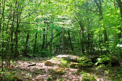
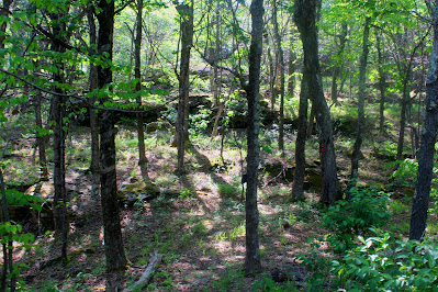
| The forest remained heavy with beeches all the way up the mountain, although the sun-filtering canopy gradually became lower. |
 |
| The landscape was brighter nearer to the summit, as some of the higher-elevation trees had yet to fully leaf out. |
Closer to the top, I crossed paths with a red-blazed Onteora Club trail which seemed to approach the summit. I'm always wary of following unknowing trails, especially while trespassing, as I never know where they'll take me, but I decided to follow this one for a bit. As it turns out, one of the club's trails leads almost directly to the summit of Onteora Mountain, turning around just a few yards from the highpoint. A short bushwhack through fairly dense spruce trees led to the highest point. Onteora doesn't have much of a summit plateau, it's more rounded, which means it actually has a clear highest point which always makes things easier. |
| Open, grassy forest along the red-blazed trail below the summit. |
 |
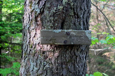
| This sign stapled to a spruce tree at the top was likely a summit marker in the past, now worn away and covered in lichen. |
 |
| Onteora Mountain, elevation 3231'. Catskill Hundred Highest 47/100. |
As with most bushwhacks, the descent from Onteora's summit went very quickly. I followed the Onteora Club trails a bit farther now, somewhat more confident as to where they were taking me, and I used my route recorded on AllTrails to find safe ways down the outcrops at certain points.  |
| Evening sunlight illuminates the ferns and rocks farther up the slopes I had just descended. |
 |
| A limited view towards Kaaterskill (L) and Roundtop (R) from a rock outcrop below the summit. |
The only sketchy part of the descent occurred on Parker Mountain, where I was following a clear herdpath and every few hundred feet, there was a mound of bear droppings. I didn't think much of it until it occurred to me that, with how fresh the droppings were, I may be inadvertently tracking a bear, alone, unarmed, in the spring. I bushed back up to the Onteora Park trail just in time to watch a single black bear lumber across and out of sight, evidently running from all the noise I was making. While I've seen many bears on drives and at home, this is the first time I've run across one while on a hike and it was a bit startling.
 |
| Thomas Cole Mountain seen from the overlook on Parker Mountain. |
 |
| A house on Route 23C in East Jewett, far below the overlook. |
 |
| To the northwest, Mount Hayden peers over the western limb of Caudal. |
 |
| A real-life Easter egg: A painted rock on the trail encouraging people to daydream. |
I returned to the road fairly quickly and headed back to the arboretum, thankful for a safe and successful hike. My longest private land bushwhack so far, done after a full day's work, under constant threat of being caught, getting lost, and, apparently, the local wildlife, was done. |
| Kaaterskill and Roundtop rise beyond the historic All Souls' Church on Route 23C. |


Hello - I was hoping to ask you a few questions about this hike if you'd be willing. If so, please email me at daniel.nicponski@gmail.com
ReplyDeleteI am NOT in any way associated with the Onteora Club!