Arkansas: State High Point 22/50. Elevation 2753'. Solo ascent via Signal Hill Trail. 0.98 mi, 148' elevation gain, 16m RT."Lord willing, I'll be on top of Arkansas this time tomorrow."
"Well I guess He wasn't," I mumbled to myself as I struggled to turn the jack under my car.
I was on a backroad somewhere outside of Arcadia LA, heading out from Driskill Mountain, when I encountered the first major inconvenience of my three-day highpointing trip: a flat tire. What's worse, I was on my way back from college, so practically everything I owned was stuffed in the trunk between me and my spare. I cut myself on the pavement trying to jack the car, but managed to get the spare on with little difficulty and a lot of sweat in the burning sun and mid-90s temperature.
I knew that this flat had happened for a reason; God was reorganizing my itinerary for the next three days, so I was grateful for it, but in the moment I was still pretty annoyed. I found a Wal-Mart in Minden that sold me a new tire, since the hole was too big to patch, and disposed of the old one for me. I changed it out for the last time in the parking lot and was back on my way. All my things were covered in grease and I was more exhausted than either of the day's hikes had made me, but all was well once again.
My original plan had been to hit Mount Magazine that evening, then camp at a trailhead farther north in the Ozarks. However, with this delay, I wouldn't make it to the Arkansas highpoint until well after sunset, which meant that the hike tomorrow morning probably wouldn't happen at all. This was frustrating, and I spent the next few hours on the road improvising a new game plan. I slept at a rest area for the night and decided to do Mount Magazine in the morning; I'd work out the rest later.
I woke before the sun and drove over an hour of backroads to Mount Magazine State Park, arriving at the trailhead just after sunrise. The ride in was beautiful, combinations of flat fields and sudden mountains with forests and small towns scattered all around the whole way. It also happened to be my birthday, one of the big ones at 25, and I could think of few better ways of spending it than exploring a state - for the first time at that - in quest of another highpoint.
 |
| A view of the hills over Cove Lake, near the base of Mount Magazine, from Route 309. |
Mount Magazine is a fairly well-developed state park with roads, overlooks, campgrounds, and even a five-star hotel near the summit. It's a very popular spot, but early on Mother's Day morning it was fairly empty, which meant I could take my time without holding anyone else up. There was plenty of wildlife out and the trees still had that beautiful light green color of new growth, which was absent at lower elevations. I parked at the trailhead, located just outside the campground, and headed off on a rather short hike to the top. |
| A young buck eyes me carefully as I drive by, contemplating whether he should jump on my car. |
 |
| Sign at the trailhead for the Signal Hill, Mount Magazine's highest summit, |
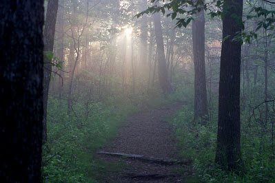
The morning's misty clouds still hung over the very top of the mountain, making for foggy conditions on much of the hike up. While the path to the top of Arkansas isn't very long, only about half a mile, it has some decent elevation gain, so I felt like I actually earned it at least a little bit. The forests here were beautiful, with lots of grass on the forest floor and decently thin density, everything an almost unrealisticly bright spring green. |
| Fog fills the gaps between the trees in the grassy Ouachita forest. |
 |
| Rays of sunlight shine through the fog along one of the flatter portions of the trail. |
The summit of Signal Hill is oddly perfectly round; the ground clearly descends in every direction from the highest point. A few benches, a trail register, and a signpost mark the highest point, where the ground is covered in a large map of Arkansas with the USGS survey marker in the approximate geographically accurate spot of Mount Magazine. I spent quite some time at the summit as the fog cleared; it was beautiful here, I was good on time, and I really wanted to rest and enjoy this spot. I almost wished I could stay there all day. |
| The survey marker embedded in the stone map of the state. |
 |
| The Highpointers Foundation summit register. The name of the peak is variously given as Mount Magazine or Signal Hill in differing contexts. |
 |
| A view of the stone state map beneath the summit's sign. |
 |
| Mount Magazine AR, elevation 2753'. US State High Point 22/50. |
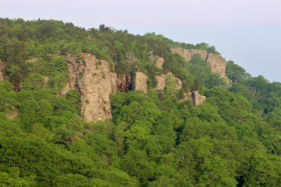
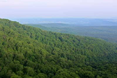
While the summit proper of Mount Magazine is beautiful, it has no overlooks into the surrounding terrain. Therefore, I headed back to my car to take the Overlook Drive, a loop road with several overlooks that traverses the top of Cameron Bluff, on the north side of the mountain. These overlooks provide views over the Arkansas River Valley to the north and west, along with stunning cliffs that cover nearly the entire edge of the wide summit plateau. Of all the places I've visited, this is certainly one of the most impressive when it comes to pure natural beauty. |
| Horseshoe Mountain pokes out from low-lying morning clouds in the Arkansas Valley. |
 |
| Looking out to the west towards the distant Ozarks, on the north side of the valley. |
 |
| Impressive cliffs surround Cameron Bluff on all sides, towering out of the spring forest. |
 |
| Low-profile rolling hills characterize the valley terrain from which Mount Magazine rises. |
 |
| Level with my elevation, clouds float over distant farms beyond one of the rocky cliffs. |
 |
| A wide view northwest from the overlook. Clouds obscure peaks in the Ozarks which are normally visible from here, but only add to the vista's beauty. |
 |
| These towering close cliffs form part of a structure known as the Amphitheater towards the north end of Cameron Bluff. |
 |
| Another view over Mount Magazine's limb, looking more to the south. |
 |
| Clouds float over the hills in this limited view from a northeasterly-facing overlook. |
As I drove out of the park, I carefully considered my next options. The Centerpoint Trail, part of which I had planned to hike, was no longer feasible. It was roughly a six-hour drive to my next top, Taum Sauk Mountain, the highest point in Missouri. However, the fastest route here stayed in the flatlands and on fairly major highways - the most boring trip imaginable. Adding an hour to the journey would take me through the Ozarks on twisting mountain backroads, and still get to the mountain in a reasonable timeframe. My next move secure, I sped away towards another new state.


No comments:
Post a Comment