One man's exploration of God's worldwide creation. My main focus right now is on highpoints, be they states, counties, or towns, but any mountain, road, or geographical oddity is fair game.
State High Points: 37/50
Adirondack High Peaks: 19/46
NY County High Points: 39/62
Catskill High Peaks: completed 2022-01-04
In pursuit of my fairly recent goal of hiking state high points, I set out on a frigid Thursday to hike Mount Frissell, the highest peak in Connecticut, located in the Taconic Mountains in the northwest corner of the state. The traditional trail up Mount Frissell is located on a seasonal road, and I wasn't quite comfortable taking my car down there in the winter, so I decided to hike from the New York side of the border, summiting Brace Mountain before reaching Frissell.
What followed was one of the most dangerous hikes I think I've yet hiked. The trail up the side of Brace Mountain is covered in exposed rock scrambles, often seeming more like rock climbing than hiking. To make matters worse, these scrambles were covered with ice and snow, making safe routes up incredibly hard to find. The hike, a little over five miles in length, took me four hours to complete, and I had to cancel some other destinations I had planned to hike to. However, it did yield some of the most impressive views I've yet seen, due in no small part to the wintry conditions.
Mountains climbed: South Brace Mountain, Brace Mountain, North Brace Mountain, South Mount Frissell, Mount Frissell
Swirly ice crystals jutted out from the ground along the steeper parts of the ascent. These crystals are formed by mud freezing into crystalline columns, although I'm not sure how the swirly ends form.
A view from the ascent of exposed rock and snow along an unnamed hill to the south.
A view from South Brace Mountain 35 miles north to Blackhead Mountain in the Catskills. The mountain dominates the view from the Taconic Ridge.
Looking due south from South Brace Mountain over the Harlem Valley and the hills of eastern Dutchess County.
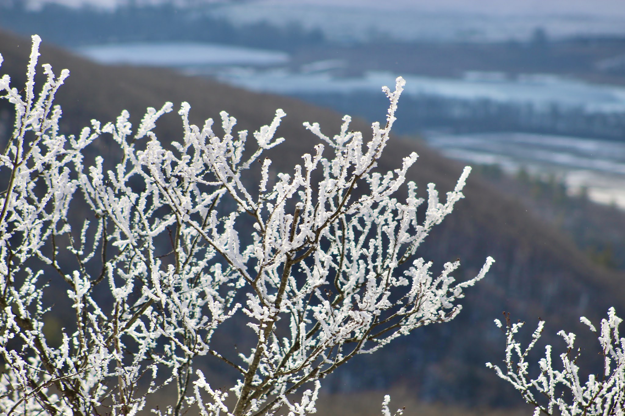
Hoar frost clings to bare branches on a shrub atop South Brace Mountain. The ridge's lower slope cuts across the background.
A three-mile view of a farm and accompanying swamp on Old Post Road in the town of North East NY.
Looking south again towards farmland on the slopes of Rattlesnake Hill, northeast of Amenia.
Red haze coats the southeast horizon beyond frost-encrusted shrubs.
A view of an unnamed island in the ice-coated Riga Lake on the Connecticut side of the border.
A panorama from the summit of Brace Mountain. At 2322 ft, Brace Mountain is the highest point in Dutchess County.
A panoramic video I took from Brace Mountain's summit. High winds and low temperatures kept it from being as steady as I would have liked. The peak is home to some of the most beautiful scenes I've ever seen.
Looking northeast towards the Catskill from Brace. The main peak in the center is Blackhead, with Stoppel to its left and Windham to its right.
Looking east revealed the snowcapped dome of Bear Mountain, Connecticut's second-highest peak.
A nice view atop Brace Mountain combines snowy ground, frosty trees, hazy mountains and clearing skies.
Although the Catskills form an impressive part of the skyline, the rolling countryside of the Hudson Valley contributes significantly to the beauty of the view.
Clouds draped over the distant High Peaks while sunlight shone over the nearer landscape.
Even from so far away my attention was homeward; bits of Cairo and Greenville can be seen at the far right, beyond the mountains.
About an inch of hoar frost clung to the leeward side of the flagpole atop Brace Mountain.
Alander Mountain, another Taconic peak nearby in Massachusetts, seemed so serene covered in soft January snow.
The Harlem Valley Rail Trail, a walking/biking trail laid in an old railbed, cuts through a half-frozen swamp near the source of the Norster Kill.
An hour of map-scouring failed to reveal where this picturesque farm is located, probably somewhere in Columbia County.
A view of the marker at the CT-MA-NY tripoint. The New York side isn't visible from this angle. Curiously, the Connecticut label isn't engraved like the other two states.
Looking west up the path from Mount Frissell, the flag, windsock, and clearing atop Brace Mountain are clearly visible.
Mount Frissell's true summit is in Massachusetts, but the highest point of Connecticut lies on its south slope. This pole marks the highest elevation inside Connecticut, just along the northern border.
A cairn and register sit along the northern border, confirming to me that for a few brief moments, nobody in Connecticut was higher than I.
The state high point boasts some views southeast into a purely Connecticutian landscape. From 2379 feet up, every other part of the landscape is below this view.
An east-facing view from just beyond the high point shows a rural landscape in southwestern Massachusetts.
The soft contour of Bear Mountain abruptly gives way to the stateline-straddling hills beyond.
The limbs of Round, Gridley, and Bear Mountains cross over each other ahead of more distant hills.
A register and marker at Frissell's proper summit in MA, hidden among a dense hardwood forest.
Unbroken snow atop Frissell made mini-mountains of its own. Its fine texture to me is reminiscent of moon dust.
Even by mid-afternoon, icy frost still clung to the branches of trees along the Taconics.
Two recently-constructed wind turbines, twenty miles away in Colebrook CT, peek over a distant ridge to the east.
A northeast view through Mount Frissell's trees is most occupied by MA's Race Mountain.
The trail beat through soft snow winds through some underbrush on the way down from Frissell.
Some newly-built houses off of Boston Corners Road, down in the valley near the trailhead, from the summit of North Brace Mountain.
A nice view of the summit rock pile, flag, and windsock atop Brace Mountain. Strangely, hoar frost clings to the flagpole, but not the pole holding the windsock.
Ice and windswept snow coated the bare rocks at Brace Mountain's summit.
Looking north from Brace Mountain to the peaks of Massachusetts' Berkshire Taconics.
An antenna atop Mount Darby obscures the more rugged and distant Tom Ball Mountain.
A view northwest shows buildings in the center of Copake NY, left of center.
A helicopter flies in late afternoon's haze over the southern foothills of the Catskill Mountains.
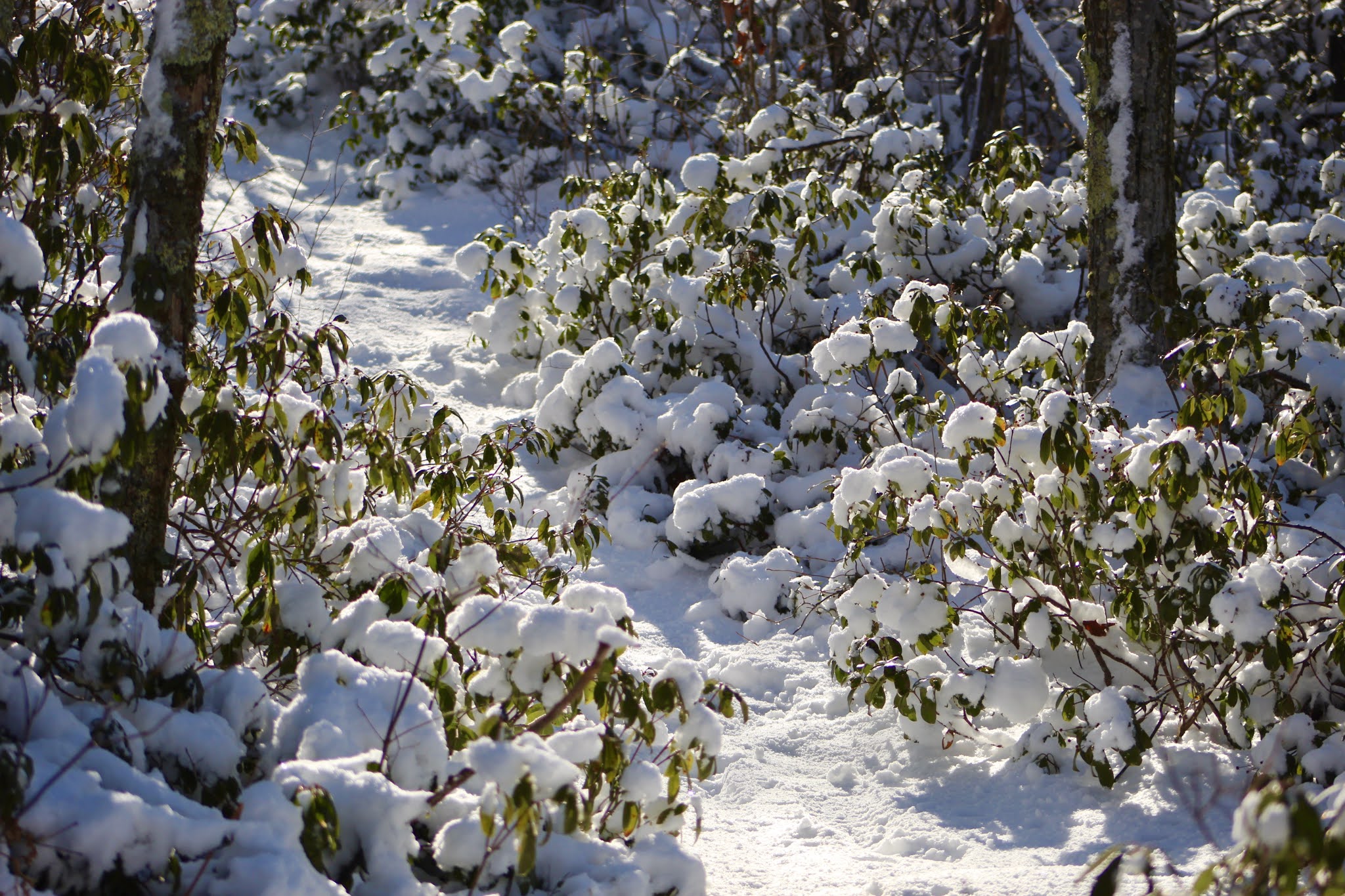
Inches of snow weigh down evergreen shrubs along the path between Brace and South Brace.
A view south from South Brace Mountain reveals a part of Lake Riga that hadn't yet frozen over.


Lovely!
ReplyDeleteAmazing Jacob. Beautifully pictured and narrated.
ReplyDelete