On a hot day in mid-August, I hiked Mount Greylock, the highest peak in the state of Massachusetts. My first hike entirely inside Massachusetts, I followed the Bellows Pipe Trail on a six-mile, 2000-foot hike to the peak's summit of 3488 feet. A highway winds up the mountainside to the observation tower at the summit, which made the peak rather crowded, especially for a Tuesday afternoon. Temperatures in the mid-90s made the relatively straightforward climb seem more challenging than expected, but it was still well worth the trouble to conquer my second state high peak.
 |
Afternoon light drapes through the forest along the Bellows Pipe Trail about a mile below Greylock's summit.
|
 |
A panorama from the southeast-facing overlook at the mountain's summit.,\
|
 |
A bit of curvature is seen in the hills beyond Adams, the town at Greylock's base.
|
 |
The Adams Quarry sticks out in this more easterly view from the overlook.
|
 |
A view farther south overlooks the upper Hoosic Valley.
|
 |
| Humidity give a whitish hue to farmlands on the east side of Adam. |
 |
Rolling forest and some fields extend beyond a small hill known as the Pinnacle.
|
 |
A close shot of downtown Adams, including its large cemetery and many church buildings.
|
 |
| Borden Mountain, right of center, is one of several hills that line the horizon to the east. |
 |
A closer view of the Adams Quarry, where marble is extracted for construction.
|
 |
Windmills line the distant slopes of Crum Hill to the northeast.
|
 |
Forest and farmland line Route 116 southeast of Adams.
|
 |
Another view of the Pinnacle and some of the areas beyond it on the far side of the valley.
|
 |
A shot of historical buildings on Hoosac Street in central Adams, a mere three miles from the summit.
|
 |
The sizable Maple Street Cemetery was one notable landmark visible from the mountaintop.
|
 |
A close-up of power lines to the north revealed bright streaks to be composed of bare rock and dirt. The rocks of the Berkshires are much brighter and more reflective than those of the Catskills or the Adirondacks.
|
 |
A new house under construction near the outskirts of Adams.
|
 |
Bright excavated material at the south side of the Adams Quarry.
|
 |
Houses near the trailhead on Gould Road, where I parked and started the hike.
|
 |
A view of the four-mile-distant Hoosac Valley High School, the most easily visible building outside of the town.
|
 |
Farm buildings line East Mountain Road on the far side of the valley.
|
 |
Severe humidity made everything seem farther away than it was, including this four-mile view of Henry Wood Road.
|
 |
The Veterans War Memorial Tower, located on the summit, was closed due to COVID concerns.
|
 |
A scale model of Mount Greylock and the surrounding regions was one of many features along the paved road at the summit.
|
 |
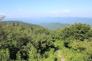
Fitch (L) and Ragged (R) Mountains characterize this more wilderness-focused view along the Appalachian Trail, just north of the summit.
|
 |
| The north-facing view had significantly more mountains and hills, looking out towards the bulk of the Berkshire Mountains. |
 |
| A view near North Adams includes the Massachusetts Museum of Contemporary Art (bottom right). |
 |
Windmills spin along Bakke Mountain, near the Vermont border.
|
 |
A close view of the nearest of Ragged Mountain's many summits.
|


No comments:
Post a Comment