Towards the end of June, I took a trip to various interesting natural formations around upstate New York. Some of these were places I had meant to go for some time, others were more spur-of-the-moment excursions. On the first day of this trip, I hit two main locations: Ausable Chasm and Barnhart Island.
Ausable Chasm is a privately-owned park in Ausable NY. Several miles of hiking trails with a wide range of difficulty line a deep canyon carved by the Ausable River in its journey towards nearby Lake Champlain. Marked by stark cliffs, strange rock formations, and beautiful waterfalls, the hike - while a bit pricey - provided some of the most stunning scenes I had seen in quite some time.
Barnhart Island, on the other hand, is far more subtle. Located in the St. Lawrence River in the town of Massena, this low, sandy island is taken up almost completely by a state park. The island's north tip is the northernmost point of land in New York, at a latitude of 45.013 degrees north.
 |
Although most trails are on the north side of the Ausable River, some views from the south side are available. This spot overlooks another overlook.
|
 |
Although they appear a dull color when dry, the rocks of the canyon walls turns a vibrant red-brown when moistened.
|
 |
The Rainbow Falls seen under the bridge on US-9.
|
 |
Although notable in their own right, these lesser, unnamed falls are dwarfed by their nearby cousin.
|
 |
A pump station sits in front of the Rainbow Falls, spewing overflow from a dam upstream.
|
 |
| Down in the canyon, steep, imposing walls encompass the calm river. |
 |
Rope bridges stretch across deep cuts in the rock, connecting trails along the canyon wall.
|
 |
Jacob's Well, a deep natural hole in the rock face along the cliffs.
|
 |
Midday sunlight somehow worked its way into the canyon, illuminating life-filled rockslides and crevasses along the chasm walls.
|
 |
Old fallen trees line a jagged cliff along the far wall.
|
 |
A closer shot of a precarious-looking rope bridge. These bridges, along with other dangerous parts of the park, were closed at the time due to COVID concerns.
|
 |
A view from a ledge, showing the trail (bottom) as it winds along near the canyon floor.
|
 |
Another rope bridge stretches out over frightening rapids below.
|
 |
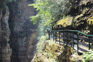
This view of the moss-lined cliffside shows how the trail is basically etched into the side of the canyon. In some areas it was difficult to fit between the railing and the rocks.
|
 |
A wider, if slightly uneven, shot better encapsulates the sheer grandeur of the chasm.
|
 |
Looking down from a bridge along the trail, the rather dramatic end to the canyon can be seen.
|
 |
Darkened forest in the Big Dry Chasm. This deep cut in the bedrock was easily twenty degrees cooler than the rest of the park, with hiking trails that were more similar to what one would expect from a small mountain.
|
 |
Bright trees grow above the fern-carpeted trail in Big Dry Chasm.
|
 |
From a trail atop the canyon, bridges below can be seen through the dramatic cuts in the rock.
|
 |
The Ausable River itself was filled with thousands of tiny bubble vortices throughout the length of the canyon.
|
 |
The smaller falls from earlier, seen from directly above from the US-9 bridge.
|
 |
A view upstream towards the Rainbow Falls from the bridge.
|
 |
A close shot of the falls, looking past the dam outflow and another bridge.
|
 |
| View from the beach at Barnhart Island. All of the distant trees and land seen here is across the border in Canada. |
 |
New York's northern tip is some distance from the beach, and I had to hike along the shoreline to get there. Here the point is seen, marked by an adventurous tree.
|
 |
As the St. Lawrence is a tidally-influenced river, I can't say for sure whether the nearer or more distant rock is permanently above water, and therefore the formal northernmost point in the state. I stood on both of them to be sure.
|
 |
Looking back down the island's shore. At the moment, I was farther north than anybody else in the state.
|
 |
Someone had built a tiny cairn atop this rock near the tip.
|


No comments:
Post a Comment