Today's weather was rather unconducive to a walk or hike, so I decided to take a drive down some roads to the my northwest. I was on the road for about three or four hours, and made several stops, sticking mostly to backroads and county routes.
The first stop I made, below, was at the Richtmyer Tavern in Conesville NY, a historic old building in a state of mild disrepair, located in the Manorkill Valley along NY-990V.
 |
| The historic Richtmyer Tavern. |
 |
| NY historical marker outside the Richtmyer Tavern. |
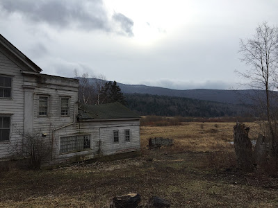 |
| View from outside the tavern. At the left is Richtmyer Peak, the fourth-highest point in Schoharie County. |
NY-990V links up with NY-30 in Gilboa, which I took north. From there I took a number of side roads towards the western portion of Schoharie County, the last of which dropped my on NY-10 in Jefferson. After driving through the town I headed eastward, taking some very twisty, poorly-maintained, snow-covered backroads through the wilderness of Blenheim and Fulton. I stopped along the way at one of the parking spots for the Long Path, in Burnt-Rossman Hills State Forest in Blenheim, one of the largest state forests in New York.
 |
| Hemlocks in Burnt-Rossman Hills SF in Blenheim. |
 |
| View upstream on the West Kill in south Blenheim. |
 |
| Downstream view of the West Kill. |
Eventually the backroad spit me back onto NY-30, which I followed up to the town of Schoharie. From here I headed eastward again, through Wright and Knox before becoming somewhat lost in the town of Berne. Eventually I ended up at the Partridge Run Wildlife Management Area, a park with which I was somewhat familiar.
 |
| A quarry, owned by the Albany County Highway Department, on the outskirts of Partridge Run WMA. |
 |
| All the roads in the area were dirt and covered in snow and ice. |
 |
| This stop sign, like most in the area, has been used for target practice with some regularity. |
After leaving Partridge Run I did end up a little lost again, and bouts of fog at higher elevation only exasperated this. However, the myriad of numbered county routes in southwest Albany County eventually led to downtown Rensselaerville, somewhat closer to home than I expected to be. I made one more stop at Sikule Pond, south of the town, before continuing on home.
 |
| Sikule Pond, in south Rensselaerville, was iced over and covered in a dusting of snow. |
 |
| Surrounded by forest, the edges of Sikule Pond are a more wetland-like environment. |
Although not as healthy as a three-mile walk, the drive covered a lot more ground and was just as thoroughly enjoyable a way to finish 2018. Here's to more walking, driving, and pretty pictures in the year to come!


No comments:
Post a Comment