After a long stretch of terrible weather (mostly rain and wind, with some snow), the skies finally cleared for a while this Christmas Eve. Rather than continue my walking of Durham roads, I decided to take the bulk of the day and climb Windham High Peak, the northernmost of the Catskill Mountains. This marked my fifth ascent of this mountain, the third in 2018, and the first in below-freezing temperatures.
 |
| View of the mountain from the trailhead. |
I parked at the Elm Ridge trailhead along NY-23. Although this is the most distant trailhead from the mountain's summit, it's high elevation and location along a major road makes ascent easier and travel to the parking area safer. From the base I could see the summit, looking quite distant (and cold).
 |
| Hemlocks in Elm Ridge Wild Forest. |
Following the Escarpment Trail up the mountain took me along a path that initially was rather flat, moving through deep hemlock forests. The sky at this point was clear.
 |
| Scattered snow in the deep forest. |
The farther up the mountain I hiked, the more snow there was. Most of the season's snow was wiped away by an unseasonable heat wave last week, so all of this had fallen in the past day or so.
 |
| Steep slopes before the Elm Ridge Lean-To. |
The final junction in the trail was located just before the Elm Ridge Lean-To, a three-walled shelter on the edge of a deep spruce forest. Before this final junction, the trail climbed dramatically in a zig-zag pattern to the top of Elm Ridge.
 |
| This stream marks the approximate halfway point along the trail. |
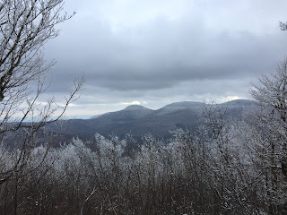
After nearly a mile of deep spruce forests, the environment opened up into a forest of bare maple trees, with intermittent views of the Blackhead Range to the south. By now the sky had grown grey.
 |
| View of Acra Point from near the summit. |
Despite the elevation, Windham's south slopes' exposure to more sunlight meant the snow was actually shallower than farther down the trail. As the path wound up towards the summit, views of the Blackhead Range and the eastern Escarpment peeked through the bare trees, giving a good reading of how high an elevation the trail was.
 |
| The area around the north-facing overlook. |
Windham's summit, its elevation too high for deciduous trees and winds too powerful for tall evergreens, was covered in bare scrub no higher than ten feet. All these bushes were encrusted in a thick layer of crystalline ice, giving the path an almost magical feeling.
 |
| Ice-encrusted trees at the summit. |
The path went through some fairly thick brush, which rained ice on me whenever I brushed against it. The few evergreens at the summit were covered in thick plates of ice.
 |
| The almost magical appearance of the Christmas Eve summit. |
The trail ran for a good distance along the admittedly small summit, connecting three overlooks. The scrub was short enough that I could see across fairly long distances.
 |
| View from the eastern overlook. |
Windham's summit formed the tripoint between the towns of Durham, Windham, and Cairo. The eastern overlook, located maybe ten or twenty feet below the summit, is located in Cairo. It looked out Windham's northern limb, the plains of the upper and middle Hudson Valley, and farther out towards Massachusetts and Vermont. This was by far the widest overlook on the mountain, and the curvature of the earth could be seen from it.
 |
| View from the northern overlook. |
The mountain's northern overlook, located in Durham, looked out towards the Capital Region and the upper Catskill Valley. To the left, the Hayden Range could be seen behind the trees, while the more distant hills towards the Schoharie Valley, usually quite prominent, were obscured by approaching snow. It had already begun to snow on top of the mountain by now.
 |
| View from the southern overlook. |
Windham's southern overlook, located in Windham, looked back towards the Blackhead Range. The summits of Blackhead, Black Dome, and Thomas Cole mountains rose prominently from the mostly wilderness Big Hollow that separated them from Windham itself. To the left of Blackhead, the Escarpment ridge connecting them formed a prominent wall.
 |
| Dense spruce forest below the summit. |
As I was already tired, the hike down went by as sort of a blur. The snow never really intensified while I was on the mountain, so it didn't provide a major hassle, although I did once slip on an icy rock, sliding some distance down the trail. Going back through the spruce forests was quite wonderful. The round-trip hike took me just short of three hours, totaling over seven miles distance and about 1550 feet elevation gain.
Holiday events prevented me from posting this yesterday as I would have liked. I would like to wish everybody a safe and enjoyable (or at least tolerable) Christmas and holiday season.


No comments:
Post a Comment